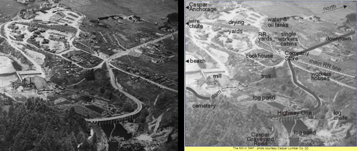
The History Page of Caspar CA Community WebSite, Shows The Above 1947 Aerial Photo of Caspar CA => We See Clearly Where Old US-1, Came From the Town of Caspar, And Curves Down Toward the Beach.
.
we climb on the cycle and go slowly south looking for a restful place to pull off. .. The road leads out to the ocean again
.(Cont.Next)
Caspar Bay ~ one mi South of Caspar, CA.
The /\ Above 1947 Aerial View, Fits Exactly TO THE PREVIOUS PHOTO (Having A Satellite View) => Where It Said You Can Imagine Where a) Old US-1 Curved Left; d) And Crossed Caspar Creek; e) And Then Connected to Point Cabrillo Dr.
.And also you can see how nearly all of the 1947 streets appear in the Previous Satellite View Photo. AND even The Caspar Inn appears in both!
.Wikipedia says The Caspar Inn existed continuously as a roadhouse from the heyday of the logging era in 1906 to February 2013. Excerpt From Wikipedia. More Good History Information, and Six Very Nice Photos. Click Here.
.Wikipedia also says Important date => turned Caspar into a significant logging town in Northern California from 1864 to 1955
. Thus it would seem very likely, when The ZMM Narrator came thru, back in 1968 (13 years later) that => The then existing US-1 (as is shown in /\ Above /\ Photo), must have gone South from The Caspar Inn, then SE as the Caspar Rd went down the slope of the North bay-side, curve around, cross Caspar Creek, and then join & continue West where Point Cabrillo Dr is seen in the Previous Satellite View Photo.
.Other Parts of the Puzzle Now Solved.
In /\ Above /\ Photo, we can see that the bridge over Caspar Creek, is relatively long, high, and large, AND made of wood. Thus this expensive bridge would eventually weaken from rot, and with the end of the Saw Mill and Logging in 1955, there would no point in replacing it.
.Moreover, by the 1960s there would be far more traffic of faster cars & trucks, than The Old US-1 could handle through the Caspar Town. Leading to construction of the New US-1 By-Pass. Please send an email if you know the dates of this construction.
.
.And One More Puzzle Solved.
..A) WHY Satellite & Topo Maps do not show the slightest trace of a road from where => Caspar Rd went SE down the slope of the North bay-side, to where would join & continue West on present day Point Cabrillo Dr.
..B) ANSWER: This whole roadway distance was a Wooden Bridge, and when rotted down, would nicely regrow in trees, leaving scant evidence, that anything was there, beyond old stone piers that once held up the wood!
. RIGHT CLICK AND SELECT NEW TAB => After This Caspar Community Page Comes Up, You can read A Good History Of Town & See Five Very Nice Historical Photos, beyond the two Photos from their WebPage Shown /\ Above /\ and NEXT Photo.
************************************
(Photo = CasparCAGgAerialViuCasparCA FmCasparHeadlandsHIST}Pano}Mill1947+ExplOvLy.jpg ...... ZMM Page = 366 ...... WayPt = 464w 0040ft at beach.)