What Road Did The ZMM Author Robert Pirsig (1968) Actually Use To Go From The Caspar Inn Restaurant,
To A Road Which Climbs The Slope To The Narrators A High Point From Which He Could See Where Some People Rest In The Sand
I look for a bench somewhere in the luminous haze but there is none.] Instead we climb on the cycle and go slowly south looking for a restful place to pull off.
.The road leads out to the ocean again where it climbs to a high point that apparently juts out into the ocean but now is surrounded by banks of fog. For a moment I see where some people rest in the sand, and the people are obscured. (Cont Next)
*************************
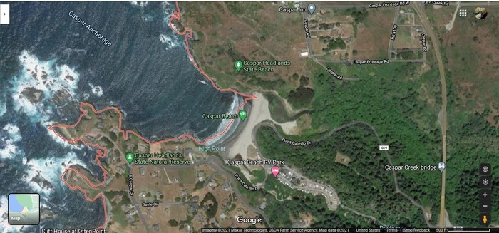
/\ Above /\.Photo Is A Satellite View Of Caspar, CA, Caspar Back Bay, Caspar Beach, And Caspar Headlands:
You Should Click On Photo Several Times To Get The Largest View, Then Study And Identify a), b), c), d), e), f), g), h), & i) =>
(a) The Caspar Inn, (b) Caspar Rd going South & Turn to (c) Caspar Rd going SE partly down the hillside; (d) Caspar Beach; (e) An un labeled Caspar Creek to right of Caspar Beach, (f) Point Cabrillo Dr and follow it (g) curving South along Caspar Beach and then (h) much curving to Northwest and climb the hillside to Narrators (i) High Point.
Now, As You Will See In The NEXT TWO Photos, Caspar Rd going SE partly down the hillside at (c); once-upon-a-time connected to a High Wooden Trestle Bridge, which sloping down and curving around to the Southwest, Crossed Caspar Creek (e) And then connected to Point Cabrillo Dr; And then following (f), (g), (h) and then climb the hillside to Narrators (i) High Point, which is the Narrators => a high point that apparently juts out into the ocean .
THUS, IN SUMMARY => This is how OLD Rt-1 went South from Caspar, CA and most likely was how the Narrator & Chris got from the restaurant in town, to the Narrators => A High Point From Which He Could See Where Some People Rest In The Sand
DATE-LINE: January, 2021. by Henry Gurr.
.If you study the /\ Above Satellite /\ View (Imagery 2021), you can see that => The ONLY way with current day roads, to get from the Caspar Inn (The ZMM Restaurant Location in the Town of Caspar, CA.)
TO THE OTHER SIDE OF Caspar Bay AND BE AT => The ZMM Climax Scene, which is marked in /\ Above /\ Photo >> In Mint Green >> High Point, which is the Narrators. A High Point
The ONLY way, is to go the relative long distance of first going East on town streets, to the Newer Four Lane Present Day Rt-1. (This is the Caspar By-Pass Which is the slightly curved major highway at the right of /\ Above /\ Satellite View, and shows Caspar Creek Bridge):
And then go West via Point Cabrillo Dr; to the Narrators A High Point.
..This much longer, circuitous route is most certainly the roads I had to use in 2002, and most certainly this route does not fit the Narrators description.
This Rather Long, Circuitous Route Would Take Far More Time Than The ZMM Narrative Allows For.
. Thus, back in 1968, the then existing Rt-1, must have gone directly South from the Caspar Inn, first going South on Caspar Rd, then continuing SE on Caspar Rd, and started down the slope of the hillside.
This is seen in the /\ Above /\ View, as a road going SE down the hillside, that gets weaker and dead ends in the trees.
AND NOW, In The /\ Above /\ Satellite View, We Can Imagine & Visualize That =>
The continuation of the SE down the slppe Caspar Rd, back in 1968, would curve around onto a trestle bridge to the Southwest, cross Caspar Creek, and then join & continue Northwest where Point Cabrillo Dr is seen going back up the hillside.
SIDE NOTE: In the /\ Above /\ Satellite View, the Pink Line shows a boundary for A Caspar Census-Designated Area, and can be ignored.
In My 2002 ZMM Route Research, I was UN-able to find this old road down the cliff on the North side of the Bay. This is reason for no photos of it.
.But the NEXT TWO Photos (1947 & 1939) will show this Old Rt-1, AND The Trestle Bridge Very Clearly =>
a) 1947 Aerial View.
b) 1939 National Geographic Color Photo.
Topographic Maps, Can Often Better Show The Steepness of Slopes, Than Satellite Views.
. To find & study a TopoZone Map of the Caspar, CA Area => Click on the Blue Link below, and AFTER the map comes up, you will see the old Rt-1 Road, as the short dead-end-SE angle-down-segment above the letters BM. From this, you can visualize that the OLD Rt-1 Road crossed the back-bay between the BM and the 41 on the TopoZone Map.
. To See Caspar, CA and Caspar Bay on a Topo Map => RIGHT CLICK AND SELECT NEW TAB.
An AFTER Map View Comes Up, You Will See An AWFUL Clutter of Adverts That Are Impossible To Eliminate => YOU BEST SHOULD =>
.Use Scroll Bar At Far Right To Adjust Green Topo Map Until You See JUST BELOW The Plus&Minus Upper Left. => A ClickOn For Full Screen. Click On It, And Adverts Will Be GONE.
.Then Use Plus&Minus To Zoom. You Can Click&Drag Map In Any Direction, To See More Off Your Screen Edges.
The /\ Above /\ Photo Was A Screen Capture Of A Google Map Satellite View. For Further Study You May =>
. Right Click And Select New Tab: And AFTER This Satellite View Comes Up, You May ClickDrag To See Parts Off Scree Edges, And Click Lower Right, To Zoom In. *************************
(Photo = GoogSat CasparCA+CasparBay+CasparHeadlsnds+NarratorClimaxScn(MkdHighPoint)+US1.jpg ...... ZMM Page = 366 ...... WayPt = 464w 0040ft)