The History Page Of The Caspar, CA. Community WebSite, Shows The Above 1939 National Geographic Cover Photo of Caspar, CA.
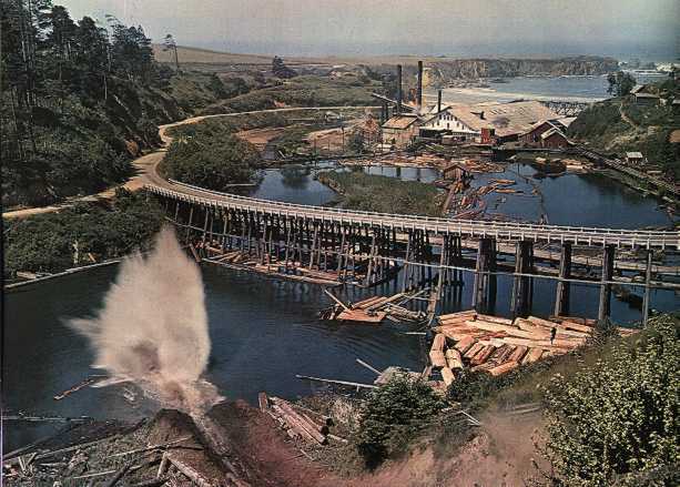
We AGAIN See Clearly Where The OLD Rt-1 Came From The Town of Caspar, And On A Wooden Trestle, Curves Down Toward Caspar Beach.
Caspar Beach Is The White Strip, Seen Just Above The Roof Of The Big Sawmill Building.
.[ AND the road shown in /\ Above /\ Photo, fully fits the ZMM Narrative => ]
.
we climb on the cycle and go slowly south looking for a restful place to pull off. .. The road leads out to the ocean again
. (Cont Next)
.
Caspar Bay, about one mile South of Caspar, CA.
Thanks To ZMMQ WebSite Editor David Matos, For The Following
Which Is Content He Posted July 24, 2022, On Our Facebook.com/zmmquality
This /\ Above /\ photograph of the Caspar sawmill just south of Caspar, CA graced the cover of the March 1939 edition of the National Geographic Magazine. In the foreground, a log splashes from chute into a log pond on Caspar Creek and the Caspar Bridge takes Highway 1 across the valley.
Behind the sawmill, Caspar Bay is visible with a white strip of beach just peaking out above the sawmill.
Enclosing the bay in the top right hand corner of the photo, the rocky cliffs of Point Cabrillo can be seen, the place on the Mendocino coast where the climactic scene in Robert M. Pirsigs Zen and the Art of Motorcycle Maintenance takes place.
Caspar, CA is a small unincorporated community started as a logging sawmill town. In 1850, an opium trading brig named the Frolic on its way from China to San Francisco during the gold rush sank just off Point Cabrillo. The subsequent investigation led to the discovery of Redwood forests along the Mendocino coast and the later establishment of the timber industry there.
The Caspar Lumber Company operated from 1864-1955. A dedicated rail line was built into the interior, ultimately 28 miles in length and some of the largest trees ever felled came through Caspar. Lumber was shipped from Caspar Bay via dog-hole schooners so named for their small size.
The March 1939 issue of National Geographic celebrated the opening of the Golden Gate Bridge and the northern coast of California to car traffic, which prior to was easier to travel to by dog-hole schooner and later steamers. Pirsig Pilgrims today can stop in the town of Caspar and at Point Cabrillo Light Station State Historic Park.
LEARN MORE
View Henry Gurrs photo albums illustrating Zen and the Art of Motorcycle Maintenance. This page will take you directly to the Mendocino Coast and discussion of Caspar, CA.
http://venturearete.org/ResearchProjects/ProfessorGurr/gallery/album09?page=11
ATTN: HENRY->
The Caspar, CA website includes more historical background, including a great 1966 photo of the Caspar Bridge that will help Pirsig fans envision the scene in Chapter 31.
https://www.casparcommons.org/HHistory.php
Wikipedia entry Caspar, CA.
https://en.wikipedia.org/wiki/Caspar,_California
..****************..
.Attention: This History Page of Caspar CA Community WebSite Page Has An Interesting History of the Town And History Of Their Redwood Lumber Mill.
There are 8 very Interesting Historical Photos, One of these photos shows The Big Long Curved Wooden Trestle Bridge, dated 1966. This photo is important, since factually establishes that this bridge was very likely still there when Robert Pirsig went through Caspar, CA, in 1968.
Click Here To See The Original WebPage For => The Text Above And The /\ Above /\ Photo Of => The 1939 National Geographic Cover Photo of Caspar CA
*************************
. To Further Explore This Area or ZOOM IN => RIGHT CLICK AND SELECT NEW TAB => => After Satellite Map View Comes Up, ClickOn The Plus&Minus To Zoom. You can Click&Drag Map In Any Direction, to See More Off Your Screen Edges.
*************************
Thanks To Professor Gary Wegner Whos Old Website Once Showed An Aerial Photo That Clearly Showed The OLD Rt-1 Crossing Casper-Bay:
.Back in ~2005, an older version of Professor Gary Wegners Website once had a good Aerial View of Caspar CA. that clearly showed the OLD Rt-1 directly crossing Casper-Bay. But since this WebSite no longer showed this Aerial View, Henry Gurr was able to Google and find /\ Above /\ Photo as well as the Previous Photo.
You May Learn More About Professor Gary Wegners Efforts =>
A) Click Here For Professor Gary Wegners Current WebSite Showing Photos Along The Route Of Robert Pirsigs Book ''Zen And The Art Of Motorcycle Maintenance, (ZMM).
B) Click Here For Professor Gary Wegners ZMM Book Read And Ride WebPage.
*************************
(Photo = CasparCa Goog..AerialVuCasparCA SezCasparHeadlandsHIST=NatGeo39big.jpg ...... ZMM Page = 366 ...... WayPt = 464w 0040ft at beach.)