|
PLEASE NOTE: This /\ Above /\ Satellite View will help you understand MUCH Montana Geography & Geology. You at first may want to skip over, but please remember & come back when needed >> then open in a new browser window for Ez Comparisons of Discussion.
As with all these Gallery Photo Albums => Please REMEMBER to click any photo several times to get LARGEST view.
Continued From Previous Photo: An Illustration of Montana US 12 Travel East.
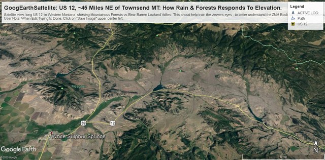
A Special Added Geography Note, Concerning /\Above/\ Satellite Photo, Of Central Montana Flat Dry Lands: . Straight East from Townsend MT, US 12 goes over a darker green Range of Mountains (discussed previous photo, called The Big Belt Mountain Range), then joining with US 89 goes north to White Sulphur Springs MT. As seen in this Satellite View, both routes follow a green valley East for ~5 miles, whereupon US 12 splits off to go generally East in semi-arid valleys, between Mountain Ranges. .It is an observed fact that higher elevations are cooler, and white areas in photo like the above are snow, which tells us where the highest peaks & ridges are.located.
.Generally an increase in elevation is enough for extra rain, thus creating forested meadows, which the ZMM Narrator Delightfully Reports in Chapter 7. In above Satellite View, the higher elevations are the darker green areas, and reliably can be used to discern relative landscape elevation:
.Another useful way to discern relative elevation, especially down-hill at a particular location, are the lines darker trees showing rain water run-off channels: In the above Satellite View, these typically surround the larger dark green mountainous areas, and a characteristic of interest in this Satellite View. These streams provide irrigation water for agriculture areas, which show in this satellite view, as Lighter Colored Patchy Areas, some of which are circular or rectangular, showing presence of human activity!
.Many places you see these darker tree lines that come together, and become larger. If you follow these, they eventually become large enough to have sandy bottom, twisty-curvy, dry stream channels. If you pay attention to these, you can use these to identify the general downward slope of the surrounding land. Not as good as a Topographic Map, but good enough for lots of purposes!
.We hope you, will take some time studying these darker tree lines, where you can imagine run-off rain waters would flow in streams and gulches: This will train your eyes to Really See, in Google Earth Images later in this Gallery Album. :-))
Next Photo: A Panorama Scene Along The Road In SW Corner Of Dry Lands Montana.
Photo
. Posted 23 Sept 2020.
| Upload Date | : | Sat 09 May 2020 10:51:20 AM EDT |
|
|||||
|
|
RSS |