|
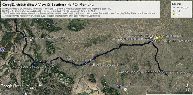
PLEASE NOTE: This /\ Above /\ Satellite View will help you understand MUCH Montana Geography & Geology. You at first may want to skip over, but please remember & come back when needed >> then open in a new browser window for Ez Comparisons of Discussion.
As with all these Gallery Photo Albums => Please REMEMBER to click any photo several times to get LARGEST view.
Continued From Previous Photo: An Illustration of Montana US 12 Travel East.
...THIS GOOGLE EARTH SATELLITE VIEW, SHOWS MOUNTAINOUS FORESTS OF WESTERN MONTANA, CHANGING TO BARREN LOWLAND VALLEYS OF CENTRAL MONTANA, CHANGING TO DRY FLATLANDS IN EASTERN MONTANA:
A) In the West
FROM Montanas Own Rocky Mountains
TO the Eastern Border of North Dakota (see straight white line). AND
B) In the South
FROM the Border of Wyoming (see straight white line)
TO In the North Mid-Montana Dryland.
.Please Close Study This Following => GENERAL INTRODUCTION TO /\ ABOVE /\ SATELLITE VIEW:
.And Thus Help You To Train Your Viewers Eyes, To Better Understand The ZMM Book Narrator's Descriptions, In the Forthcoming Phots In This Album.
Please Scan Around This View, AND Notice =>
1) Thin Lines (Yellow, White, Red-Blue), & Icons, such as US 14, US 12, I-90.
2) Small green triangles, marking highest mountain peaks.
3) Larger green triangles, marking National Forests.
4) Yellow Google Map PinPoint, For US 12, from Miles City MT to Powder River
. At right photo edge, Look close for US 12, as very faint yellow line.
5) From Henry Gurrs GPS Data, imported into his computers
.Google Earth APP=>
.
a) Tiny blue dots, marking Henrys GPS way-points.
b) Larger blue triangles, marking Henrys GPS, when he started a new day.
c) At above image left edge (yellow line going west), is I-90 icon.
d) And above I-90 icon, trending NE is I-15, to Helena: This is also marked by
...yellow line from US 12 icon, at upper left image edge.
e) Heavy Bold Black Line, Marking Henry Gurrs July & August 2019 Travel, from Bayes MT (See lower right on US 212, in SE Montana) > to Miles City MT > to I-94 West, > which joins I-90 at Billings MT > then I-90 West to Three Forks MT > And there turn North of on US 287 > On US 89 into NW Montana, and eventually Glacier National Park (GNP).
At Link Below Is => An EXPANDED & FULL Explanation Of
A) The ABOVE Google Earth Satellite View Of Southern Half Montana, AND
B) A More Complete Illustration Of Henry Gurrs Additional ZMM Route Research July-Aug 2019.
You may wish to view (in a new browser frame) => Click For An Explanation Of Important Features, That Can Be Seen In Henry Gurrs ''Google Earth Satellite Image of Southern Montana.'' As you will see => Many of these Important Features relate to The Montana portion of US 12 = ZMM Route East.
Next Photo: Special Added Geography Explanations => Concerning US 12 in /\Above/\ Satellite Photo, Of Central Montana Flat Dry Lands:
Photo File = GoogEarthSattelite SouthernHalfMontana2 NarrowerCaption .jpg
. Posted 23 Sept 2020.
| Upload Date | : | Sat 09 May 2020 10:32:57 AM EDT |
|
|||||
|
|
RSS |