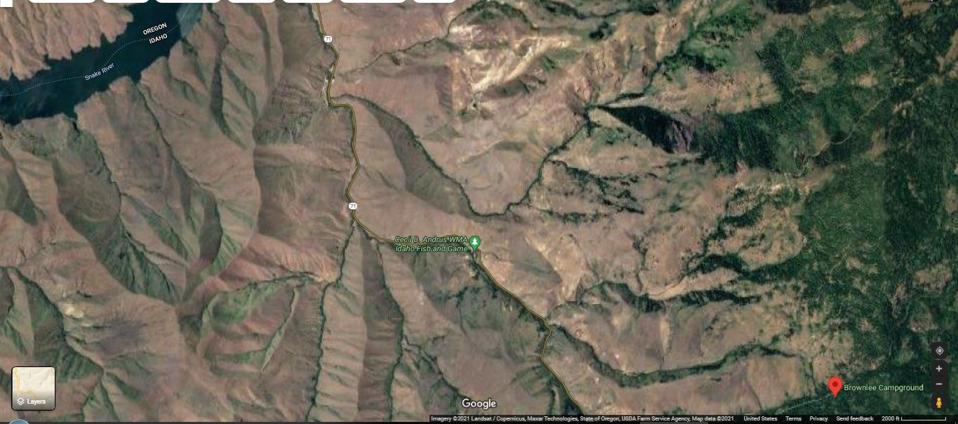
A Satellite View Of The Idaho Landscape => Showing Green Mountains At Right, Shading To Slight Greenish, Baked, Dry, Nearly Lifeless Desert, Which Are West & North of =>
. The Brownlee Campground, At Red Pinpoint Shown At Lower Right Corner.
Where Chris Says => I Like It Here.
.. And, In the Quiet Evening, Chris and the Narrator Can Hear A Small Stream Nearby.
If your look closely, the Satellite View shows some of the exact landscape features reported in the first part of the following ZMM Passage =>
. a little sign saying "Brownlee Campground," which appears to be in a draw of the mountains. In the dark its hard to tell what sort of country were in. We follow a dirt road under trees and past underbrush to some campers pull-ins. No one else seems to be here. When I shut the motor off and we unpack I can hear a small stream nearby. Except for that and the chirping of some little bird theres no sound.
"I like it here," Chris says.
"Its very quiet," I say.
"Where will we be going tomorrow?"
"Into Oregon." I give him the flashlight and have him shine it where Im unpacking.
"Have I been there before?"
"Maybe, Im not sure."
I spread out the sleeping bags, and put his on top of the picnic table. The novelty of this appeals to him. This night therell be no trouble sleeping. Soon I hear deep breathing that tells me hes already asleep.
I wish I knew what to say to him. Or what to ask. He seems so close at times, and yet the closeness has nothing to do with what is asked or said. Then at other times he seems very far away ... ] (Cont. next).
Satellite Shows The Landscape Area From Brownlee Dam Reservoir (Upper Right), To Brownlee Campground (At Lower Right), Respectively ~30 & ~18 miles Northwest of Cambridge, ID.
..****************..
FIRST Click On Photo To Get Largest View, Then Please Notice In The /\ Above /\ Satellite View Photo:
A) The dramatic effect of Landscape Elevation =>
..1) The higher elevation Mountainous Regions (Right side of photo) are cool enough to have more rain, making somewhat green from Grass, and in various rain run-off-channels, hold moisture for trees. (This includes The Brownlee Campground, at Lower Right.)
..2) The lower elevation Mountainous Regions (Left side of photo) are a whole lot lower and thus hotter, and thus lifeless-barren tan color: This is because any rain quickly runs to the gullies & temporary streams, making them green, but leaving the hillsides & tops, extreme dry & lifeless.
B) In addition => Take time to study the Green Tree-lined Stream Valleys, mostly running from The Green Mountains (at the right), flowing West toward the Snake River & The Brownlee Dam Reservoir. These green lines of life nicely fit The Rubàiyat Quatrain. =>
. With me along the strip of Herbage strown
.That just divides the desert from the sown, ..
..****************..
.The Next Four Photos show a treeless, extremely baked dry landscape, region of Idaho. In such areas, it is a surprise to see a running stream here at The Brownlee Campground.
.Ditto for the Subsequent 11 Photos, which are in Eastern Oregon, which also shows running water!
..****************..
Continued From ZMM Passage Above => If Your Look Closely, The Satellite View Shows Some Of The Exact Landscape Features Reported By The ZMM Narrator, Such As Towns, Highways, The Sign At Entrance To Brownlee Campground, And The Dirt Road Into Brownlee Campground.
AFTER This Satellite View Comes Up, You Can Additionally =>
A) Zoom out, and watch upper right till, you see town of New Meadows. It is interesting to see the wide, flat, New Meadows Valley!... THERE, you will see US-95 (ZMM Route), all the way South to Cambridge, ID. THEN, you can pick out Rt-71, and follow it to a Tight-U-Turn-In-the Rt-71 Roadway, where is exactly located the dirt road to Brownlee Campground. NOTE: At max zoom, even the SIGN at the Tight-U-Turn is visible!
B) PLUS, You Can See 5 Good Photos of Brownlee Campground => After This Link Comes Up, You Should See The Left Panel With A Photo At Upper Left. => Click On the Photo, and a Photo Viewer Will Come Up. Click On the Arrows On the Photo Bottom Center, To Move To The Next Photo.
C) The LAST 2 Photos Show & Discuss What Remains of a Silver & Copper Ore Smelter Facility that operated here perhaps the late 1800s, judging from The Style Of The Wooden Construction.
NOTE: The Blue Link above is where the 6th & 7th Photos Previous were found.
*************************
(Photo = GoogSat SnakeRvReservoirToBrownleeCmpgnd+StripsHerbageStrown+ElevationGrn.jpg ...... ZMM Page = 269 ...... WayPt = NA )
