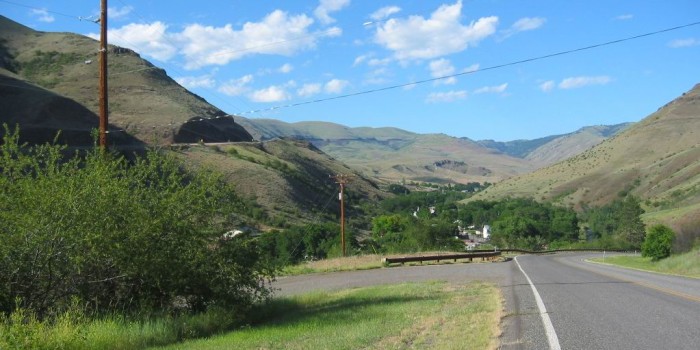
From An Access Sideroad Beside The Newer US-95, A View Back (North), Towards The ZMM Narrators Narrow Thread Of Green Surrounding The Town Of White Bird,
And Just Right Of Center, On The Distant Mountainside, Is Located The Nez Perce National Historical Park.
Stating At Left Edge Of Photo, You Can Discern The Road Cut of The Newer US-95 Highway, Which Continues To The Right, In The Dark Band Along The Distant Mountainside, To A Bit Right Of Center.
And Continuing Beyond A Bit Right Of Center, Not Discernable On Distant Mountainside, Must Be Located =>.
The ZMM Narrators
I See Our Road Will Go Down And Down Through What Must Be A Hundred Hairpin Turns
. .
.(Start Chapter 25) This morning a solution to the problem of stuckness was discussed, the classic badness caused by traditional reason. Now its time to move to its romantic parallel, the ugliness of the technology traditional reason has produced.
.... The road has twisted and rolled over desert hills into a little, narrow thread of green surrounding the town of White Bird,
(Cont. Next)
One mile South of White Bird, ID. In the /\ Above /\ Photo => The newer highway down White Bird Hill, is visible as the trace coming down the mountainside at left. As you can see, it comes down a long, steady, straight grade and remains at a much, much, higher elevation than the town as it by-passes to the West. The next photo shows how this was done.
.According to TopoZone.com, the Narrators rough & tough gravel road, with some 22 switchbacks, descends much more steeply down the relatively broad and smooth hill seen above the green beyond the town. Although the old road is barely discernable in this photo, the slightly red-color may be the exposed red soil at the road cuts. This old road finally reaches a creek canyon bottom at the upper right of the trees, and then follows White Bird Creek through the town. This road and the stream proceed, side by side, to the low area in the foreground, and then off the photo to the left. The road and creek proceed Southwest (left), at nearly the same elevation, an additional mile to the Salmon River. All this fits the Narrators passages above.
At this location, my unaware ego precipitated Low Quality! I did not drive into White Bird town, along this access road in /\ Above /\ Photo, because I was in a hurry to reach BROWNLEE CAMPGROUND before dark.
.In retrospect, I see that my anxiety and fatigue at that time, lead to this hasty, faulty, low Quality decision, causing me to miss many Excellent ZMM Route Research & Photo Opportunities!
During this time, I also failed to realize that both of my camera batteries were nearly dead. So when I got to the Brownlee Campground, I found that I had gone 15 miles past my last source of electrical power with no promise of any for 25 miles ahead!: Thus, the next day, dead batteries resulted in many more photo opportunities missed.
...Also, from the advantage of hindsight => I can now see how simple it would have been just to go into town and ask where the ZMM Narrators rough & tough old gravel road was! Obviously, this old road was in the town itself! I was low on gumption!! Moreover => I had not proceeded without desire. Better maps would have helped. But all this sad story holds Important Object Lessons :-((
.Now realizing where the Narrators 1968 road is, and where the best ZMM passage photos would have been, I chide myself for not following my hunch and taking the road (in the /\ Above /\ Photo at right), into town, and thus get a better photos for the above ZMM Passage! Of course, we now have Google Street View, which might show some good scenes. .
*************************
(Photo = 111-1139c ...... ZMM Page = 260 ...... WayPt = 284w 1681ft)