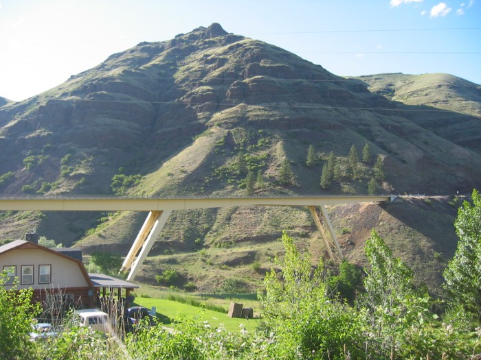
Although Achieved At Some Expense, This High Bridge, Plus Some Deep Road Cuts In The Mountain Is =>
. How the Newer HighwayUS-95, Avoids the Steep and Tortuous Hairpins of the Old Road!
. Below Bridge Is Green Along The Creek, Such As Mentioned By ZMM Narrator.
This Bridge Is Over White Bird Creek Canyon, And Above, Note Volcanic Rock In the Mountain Side.
In 1968 Robert Pirsig & Chris Likely Followed The Old Road Along White Bird Creek, Through town of White Bird, And In Canyon (Seen Under The Bridge), Continued To The Left West, About A Mile, Into The Even Deeper Salmon River Canyon.
. [
into the thread of green surrounding the town of White Bird, ] then proceeded on
(Cont. Next)
One mile South of White Bird, ID. The Narrators then proceeded on refers to his and Chriss following the old road, which is along White Bird Creek, at the base of the canyon, in /\ Above /\ Photo. Please be aware that in 1968 Robert Pirsig & Chris likely followed the old road along White Bird Creek to the left, West, about a mile, into the even deeper Salmon River Canyon. Of course, the bridge was not there in 1968.
.In the /\ Above /\ Photo => Be sure to study the color and texture of the rock in this mountain. I believe this is volcanic rock that came from an ancient lava flow called the Columbia River Flood Basalts. As you view the next photos thru number 110-1148, look for this type of rock. About 2/3 of the pictures will clearly show it, especially photos 110-1142 thru 110-1147. ((Many thanks to USCA Geology Professor Allan Dennis for his consultation (and getting it right), concerning the rocks labeled as "volcanic" and "Columbia River Basalts" in these photos.))
**************************
(Photo = 111-1140 ...... ZMM Page = 260 ...... WayPt = 284w 1681ft)