At The Top Of A Dramatic Hill, 5.5 miles before White Bird, ID.
Looking Back Toward Grangeville, We See The Cut To Lower the Road:
Here The ZMM Narrator Says =>
The Dry Plateau
. Suddenly Breaks
''
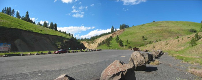
This /\ Above /\ Photo location is nine miles SW of Grangeville, ID. Due to very low humidity, and relatively high altitude => In the /\ above /\ photo, the sky is very clear and the sun is intensely hot & bright. And the sky at top left is somewhat blue black
As was mentioned by the Narrator at Beartooth Pass, Idaho is also a good place to see his dark sky & black shadows. For example => Look how black and sharp edged are the shadows of the big rocks.
. These rocks, although discolored, are likely of volcanic origin. My upcoming photos, will all show geologic evidence of an ancient and huge volcanic lava flow. To see these ancient volcanic formations, start here to study the exposed rocks in the next photos, especially photos 110-1131 thru 110-1147.
.The rocks you will see are parts of a huge and very ancient lava flows that are rightly famous for their fantastic size. These lava flows started some 17 million years ago, and for the next 10 million years, successively built up successive layers, several miles deep, over a large part of Idaho, Washington, and Oregon. These lava flows are known by various names such as: Columbia River Basalt Group, Columbia River Flood Basalts, Columbia Basalts, Columbia Plateau, Great Miocene Lava Flow, Miocene Basalt, Miocene Lava, The Great Miocene Lava Lake, or Lake Idaho.
.A 1973 U.S.G.S. report stated: The geology of the Columbia River Basin (which we have just entered) is a legacy of Miocene lava flows, volcanoes, glacial topography, and colossal [ice dam] floods.
.For more information, search the web or consult the popular books called Roadside Geology of Idaho, Roadside Geology of Washington, & Roadside Geology of Oregon.
.I believe that the Kooskia, ID
. climb to some sort of a dry, meadowy plateau is a climb up onto a volcanic cap. And indeed, this is where The ZMM Route, entered one of the Eastern lobes of this gigantic lava formation. If you have additional information, please contact me.
*************************
(Photo = 110-1120 + 110-1121sc ...... ZMM Page = 259 ...... WayPt = 281x 4164ft)