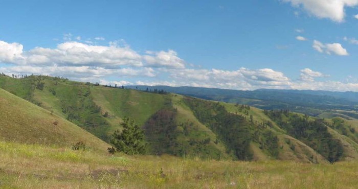
On Idahos major North-South Highway, At the Top of White Bird Hill, Looking Down, Down, Down, and South, Towards the Land East of the Salmon River Canyon.
. [the land suddenly breaks] away into an enormous canyon. (Cont. Next)
At top of Dramatic Hill, 5 miles before White Bird, ID. Nine miles SW of Grangeville, ID. On my 2002 trip here, I was unable to find the ZMM Narrators dramatic, old, gravel road with all the ~40 hairpin curves that the Narrator and Chris followed. .
Along US-o5, Just out of Grangeville ID, A Google Satellite Map shows, will show where to 45 deg turn Southeast, onto this old road, which leaves US-95, going SE, and connects to OLD US-95: This is the dirt & gravel road which Robert Pirsig took in 1968, down-White Bird Grade, to along Wite Bird Creek, and through the town of White Bird ID.. >Click Here, And AFTER This Satellite View Comes Up, The Red Pinpoint Marks the Turn-Off To Lower Portion OF the Gravel Road & 40 Hairpin Curves.
You will see that Grangeville, ID is 9 miles Northeast.
Alternatively, you may try And AFTER this very useful, many, many, very useful, featured, Internet Map comes up, you should C& P into the Box Top Center these GPS Coordinates => 45.829013, -116.246531 Zoom in till you see that here is a dirt road leaves US-95, going SE, and is OLD US-95: This is the dirt road which Robert Pirsig took in 1968, down-White Bird Grade, to town of White Bird ID.
For a Side Project: Click Here, To Learn How To Use Some Of The Many Features of Caltopo Maps. AFTER Page Comes Up, Scroll Down To => CalTopo Is Excellent For
*************************
(Photo = 110-1123+110-1124sc2 ...... ZMM Page = 259 ...... WayPt = 281x 4164ft)