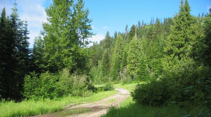
This Dirt Road Is The Most Likely Candidate for The Narrators Logging Road.
. [ On the road the shadows of the mountain trees are long now. After five or ten miles we see some logging road turnoffs and head up. ]
.The logging road is sandy, so I keep in low gear with feet out to prevent a spill. We see side roads off the main logging road but I stay on the main one until after about a mile we come to some bulldozers. That means theyre still logging here. We turn back and head up one of the side roads. After about half a mile we come to a tree fallen across the road. Thats good. That means this road has been abandoned. (Cont.Next)
The First Logging Road Turnoff, Lochsa River Canyon, ID. Starting at Lolo Pass, the highway down was a bulldozed flat area grade, on an exceedingly steep mountainside, hence no practical places for a logging road. Thus, after driving down from top of Lolo Pass, this was the first available turnoff I found. It was a right turn and was pretty well at the bottom of the steep US-12 grade from Lolo Pass. I vaguely remember that the stream was close to the road at left.
Here two different logging roads diverged from, both agreeing with the Narrators dirt road. Also this road is very sandy agreeing with the Narrators dirt road.
************************
NEW TOPIC: An Expanded Explanation of The Lolo Motorway, Which Has Been Mentioned In Previous Photos.
The National Forest Road, known as The Lolo Motorway, was created in 1935 by the Civilian Conservation Corps (CCC). Most of this work was done upon => A previous 1866 Widening Of The Lolo Trail, and Currently Can Be Traveled By Smaller Back-Country Vehicles.
NOTE: The 1935 Name Motorway does NOT mean the same as might be expected by todays paved highway standards..
On a Satellite View such as discussed above => This The Lolo Motorway is marked as 500 in White Rectangle, as seen in the below Blue Link, which is a repeat from a Previous Photo) => This Satellite View Explicitly Shows The ~119 Mile Rough, Rocky Bottom-Scraping, Dirt, Single Lane, Forest Road, Known As the Lolo Motorway.
VIEWING INSTRUCTIONS =>
.1) AFTER this Satellite View comes up, zoom-in on the Red Pinpoint, until you read words Lolo Motorway (many places on the road itself), AND see 500 in White Rectangles.
.2) NEXT => ClickDrag Map trending East-North East => To see words successively => Sherman Pass, Bald Mountain, Bald Mountain Creek, 12 Mile Saddle, Castle Butte Outlook, Moccasin Peak, Indian Post Office**, Spring Mountain**, North is Cayuse Junction, Powell Junction, Rocky Point**, Junction with 107 In A White Rectangle, which leads South, where Connects with US-12. (Persons who want to drive these roads, may need to use a GPS. )
3) Trending West-South-West you will see successively => Sherman Saddle**, Willow Ridge, Bowl Butte, Green Saddle, Weltas Meadow Campground**, Campground, Rocky Ridge, Canyon Junction, And Apparent End Of Lolo Motorway
************************
NOW Because =>
.A) This Road Offers Views of What Lewis & Clark Expedition Experienced, and Passes Many Prominent Landmarks (Especially For L & C, such as (3 inches below) marked by **.) And
.B) Since this road travels much of The Historical Native American Lolo Trail and otherwise similar landscape,
.C) Thus a person wanting The Lolo Trail Experience, might therefore try this road.
.D) We can be relatively certain that The Lolo Motorway, follows on (or close to for the most part) the Original Road by Native American Nimiipuu Tribes (the Nez Perce Tribes), from the Lolo Region.to Buffalo Country. This Trail, now also designated The Nee Mee Poo National Historic Trail, remains accurately known, because, through all the centuries, it was functional and thus would be used and reused, continuously keeping it physically stamped on the landscape, and marked in living memory, generation to generation, of where it was exactly located, for use again.
*************************
(Photo = 110-1049z.5 ...... ZMM Page = 243 ...... WayPt =. Photo at 265w 3842ft)