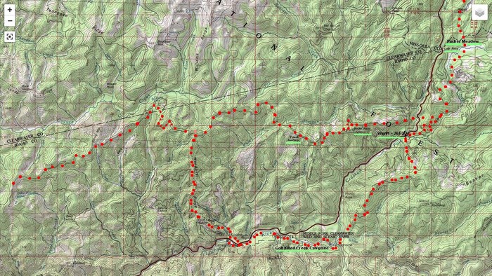
A Specially Annotated Topographic (Topo) Map, Intended To Further Show And Explain The Locations Of Major Points of Interest In The Lolo Corridor, Some Of Which Are Described In Idaho Local History Signs, Seen In The FIFTH PHOTO NEXT.
SHOWN IN /\ABOVE/\ TOPO MAP ARE THESE AS FOLLOWS =>
A) SINGLE RED DOTS MARK => The Lewis & Clark July 1805 Expedition WESTWARD Route, which they were shown by Nez Perce Native Americans Guides, along millennia old, existing well-used trails, long used by their Tribe.
. In Eastern Idaho, this is now called the Lolo Trail, which is now also designated as The Nee Mee Poo National Historic Trail (Nimiipuu Trail).
As you see between the SINGLE RED DOTS, the this Lolo Trail, follows fairly closely the marked (faint black line) of the Lolo Motorway.
B) SERIES OF DOUBLE RED DOTS MARK => A Portion Of The Lewis & Clark EASTWARD return September 1806 Expedition Route. They found their previous July Route blocked by deep snow, and again with Nez Perce Guides, used a Lower Elevation Route, which was further South.
C) REMEMBER: SEVERAL TIMES TO CLICK PHOTO TO GET LARGEST VIEW. =>THEN USE A MAGNIFYING GLASS TO STUDY =>.
.TH LOLO CORRIDOR LOCATIONS, UNDERLINED BY GREEN ARE =>
..1) Upper Right => see Packer Meadow, which is in the Clearwater National Forest where the Lewis and Clark Expedition camped on September 13, 1805, while traveling West along the Lolo Trail. .
2) Below Packer Meadow, you see Lolo Pass, which is beside a Heavy Black Line: This marks US-12 Going Over Lolo Pass, and continuing to bottom left of center.
3) Right Of Center and Mid Height, see =>WayPt = 264, which is one of Henry Gurrs 2002 GPS Waypoints, => Which here marks the location of Four Local History Signs Respectively Describing Local Natural Idaho Scenery & History. One of these signs describes how Lewis & Clark, on their return from the Pacific Ocean Coast, came through here September 16, 1805 . These four signs are shown in the FIFTH PHOTO NEXT .
4) Right Of Center and Mid Height, see =>Rocky Point Lookout. This is The "Lookout Peak" mentioned by Lewis & Clark, [and} is Clark's Lookout, a hill in Montana from which Captain William Clark surveyed the landscape on August 13, 1805.
.: Captain Clark climbed the hill to get a better sense of the surrounding area. From the top, he used a telescope, took compass readings, and sketched a map of the region.
5) Mid Height, Right of Center see => Powell Junction, a prominent way point on The Lolo Motorway (Forest Road 500), which in turn is shown & described both in the 1) SECOND REVIOUS PHOTOS Satellite View, and 2) approximately the TWELFTH NEXT Photo.
5) Bottom right of center see =>:Colt Killed Creek Campsite, Of the Lewis & Clark Expedition.
6)
Please send Email if you see more needed.
***********************
The /\Above/\ Topo Map Is Centered At => ~17 miles WSW of Lolo Pass, Which Is At The Montana & Idaho Border. (GPS ~= 46.574469, -114.923440),
This Also Happens To Show, At Left Mid-Height, The Location Of Henry Gurrs WayPoint 264, Which Is In Turn Is => The Location Of Several Times Mentioned => The Four Signs Respectively Describing Local Natural Idaho Scenery & History.
**********
PLEASE REMEMBER TO => SEVERAL TIMES CLICK PHOTO TO GET LARGEST VIEW.
***********************
A FINAL NOTE
A) The PURPOSE OF This /\ Above /\ Topographic (Topo) Map, Is To Show & Explain => The Terrain Of What Is Called => The Lolo Corridor.
B) And supply instructions as how to Further Explore this area..
C) You may see three important nice phoros, and learn more about the above-mentioned Rocky Point Lookout, several places in this WebPage =>
Click Here.For =>Discover Lewis & Clark WebPage => The Trail / Road to the Buffalo / Rocky Point Views
(Photo = TopoZnFulScr LoloPassUpRt}ShowLewis&ClarkTvll1805-1806a+TxtUgrnWy264AlbmZmmPt3.jpg ...... ZMM Page = 243 ...... /\ Above /\ Topo Map Shows Mid Right, Green Underline => WayPt = 264k 4460ft)