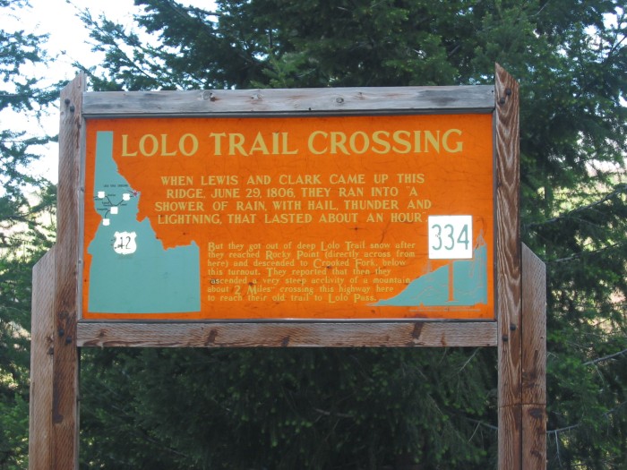
Remember To Click Several Times For Largest View: Then You Can Clearly Read => This Signs Describing the Local History, of The Mountains Seen In The Distance Of The PREVIOUS Photo.
.SIDE NOTE: Apparently This LARGE Number 344, Serves To Identify At Long Distance, What Sign This Is In Idaho Literature. This Could Help Persons In Vehicles Who Have Idaho Travel Literature, Keyed To That Number.
.After five or ten miles.... (Cont.Next)
Three miles after top of Lolo Pass At MT & ID Border. (GPS = 46.5953 -114.60013)
************************
NEW TOPIC =>
.The Three Linked Satellite Views Given BELOW, Will Help You To FURTHER Understand & Know The Present Day Highways & Forest Roads Of =>
.Approximately Same Territory As The Specially Trail Dotted Red Marked TopoZone Map, You Will See In NEXT Photo.
Each Satellite View, Shows Forest Roads & Important Landmarks, West & South Of Lolo Pass, Known As Lolo Corridor.
..A) Satellite View, Where The Red Pinpoint Marks What Has Been Named For Unstated Reasons, As Indian Post Office (7036 feet),The Highest Of The Lewis & Clark Expedition. The Corps passed the Indian Post Office location on September 16, 1805, and camped near it on night of June 27, 1806. This is West-Southwest of Lolo Pass.
NOTE1: AFTER above Blue Link comes up => At Upper Left of the Google Map, Click To Expand Side Panel => Then At lower right, Click on the Photo => To See Seven Very Nice Photos, At or around the Indian Post Office area. In the Larger Photos that come up, click on the > or < to go to the next Photo.
NOTE2: To learn more, you might Google => The above passage in quotes, for finding an entire interesting page, about the Indian Post Office.
NOTE3: The Satellite Views B) & C), below also include location of the Indian Post Office.
NOTE4: For more Information and Photos => Also see and read (in text ABOVE), Items 2) & 3) which are under => AN INTRODUCTION, WITH PHOTOS & MAPS.
..B) Satellite View Of Numbered Forest Roads West-South of Lolo Pass.
. Also seen Is Rocky Point, a prominent landmark, especially for Lewis & Clark Expedition: This was possibly a side trip for them to eventually go up to a very high lookout-point, for them to better survey the landscape for their (future & past) trail progress. Also be sure to note Massive Relatively Treeless Mountain Ridge, Lower Left Of This View.
.Red Pinpoint Marks Powell Junction, which is a waypoint, along the dirt forest road known as The Lolo Motorway => See Next Below For More Information. .
..C) .This Satellite View Fits & Adds To Above B), By Explicitly Showing The ~119 Mile Rough, Rocky Bottom-Scraping, Dirt Single Lane Forest Road, Known As the Lolo Motor Way.
VIEWING INSTRUCTIONS =>
.1) AFTER this Satellite View comes up, zoom-in on the Red Pinpoint, until you read words Lolo Motor Way (many places on the road itself), AND 500 in white rectangles.
.2) NEXT => ClickDrag Map trending to East-North East => To see words successively => Sherman Pass, Bald Mountain, Bald Mountain Creek, 12 Mile Saddle, Castle Butte Outlook, Moccasin Peak, Indian Post Office**, Spring Mountain**, North is Cayuse Junction, Powell Junction, Rocky Point**, Junction with 107 in White Rectangles, which leads South, where it connects with US-12. (Persons who want to drive these roads, may need to use a GPS. )
3) Trending West-Southwest you will see successively => Sherman Saddle**, Willow Ridge, Bowl Butte, Green Saddle, Weltas Meadow Campground**, Campground, Rocky Ridge, Canyon Junction, and apparent end of the Lolo Motor Way,
************************
ALSO SEE NEXT PHOTO OF => Topographical Map For Explanation Of =>
.The National Forest Dirt Road, Known As the Lolo Motor Way.
*************************
(Photo = 110-1047 ...... ZMM Page = 243 ...... WayPt = 264w 4460ft)