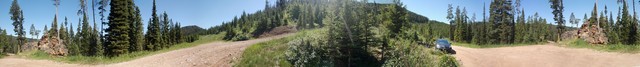
ContFmPreviousPhoto => A PANORAMA VIEW Of => Huge Volcanic Rock, Along Twisty Dirt Mountain Road: ..
12:27 pm Sun 5 Aug, Rough Rocky Brown Dirt Twisty National Forest Mountain Road, Hyalite Creek Canyon, Gallatin National Forest, South Of Bozeman, MT: Following => The vital clue Stay Left, Left, Left, Left.. => Success!! A Well-Remembered, 2006 Waypoint: A Huge & Very Ancient Volcanic Rock. Henry drove up to here on the twisty brown road, shown in previous photo. It was nearly always steep incline UP, on a car-bottom-scraping rocky rutted road. AND some 20 low places, were rain filled, deep huge muddy puddles, wider than the road. Un-avoidably
Gun the engine, down we go
Sploosh-Whump-Crunch-Bottom-Out!! Too much deep water, splash, tree branchs both sides scrapt-scrape, and Prius bad sideways slide, for Henrys comfort!
.But Eventually Reached, THIS 2006 Well Remembered Huge Pile of Ancient Volcanic Rock Pile Waypoint: And Also A Well-Remembered Road Switchback, As Shown in /\ Above /\ Panorama. .
.Henry Was Thinking To Self => FINALLY
. OK
Im on the CORRECT twisty road! So after-huge & much doubt, Im following the correct rocky, muddy, rut !! And not too far ahead, is my goal => A well remembered mountain ridge saddle-back parking spot!
.Henrys 2006 photos of this Ancient Volcanic Rock, and Fox Creek Meadow, may be viewed by click on any of the small photos. INSTRUCTIONS => Please click-on-photo several times for largest view, of Henrys. >>
Many 2006 Photos, RE-PURPOSED Into Narrator + Chriss ZMM Mountain Climb Narrative, Shown In This Photo Gallery Album Page. Click Here.
*****************
The /\ Above /\ Phoro Of Ancient Volcanic Rocks, are proof enough, that these mountains, have volcanic activity beneath: AND for the same reason as Yellowstone National Park, a mere 60 miles away. You may already be familiar with The IDEA that there is a Deep HotSpot, that is evidently under, and moving relative to The Hawaii Island Chain along with The Pacific Plate,
AND causing the sequential series of Volcanic Island Building>> Click Here and AFTER this Wikipedia Page comes up,scroll down to (and read) paragraph that has HotSpot: And then Mouse Hover HotSpot. .
SIMILARLY, there evidently was millions of years ago, another deep HotSpot, that evidently moved under Idaho & Montana, and finally IS HERE.
.Eons ago, This Deep & Moving HotSpot evidently ceated some of the worlds largest Lava Flows, from under Oregon, Then moving under Idaho, => Successively blasted out a deep valley, what is now called the Snake River Plane: This HotSpot is now apparently under Yellowstone National Park, and will => Will eventually create a spectacular blast and deeper much larger caldera, than the ~45 Mile Diameter Caldera (from a 640,000 year ago), up-lift, blast, and subsidence which formed the Ring of Mountains and Lake now there in YNP. AND From this, the heat still deep in the rocks, is responsible for tocays spatacular Gysers, Steaming Hot Springs & Steaming Hot Lakes!
.However, the /\ Above /\ Pictured Volcanic Rock, Is Most Likely From . Earlier extensive & massive volcanid flows,47 to 53 Million Years Ago, know as the Absaroka Volcanic Province Click Here.
. Click Here For => Doras Catastrophe Page: It is ~8 feet long, with huge number of good maps & diagrams!! AND throughout, Dora gives (in not so perfect writing), a good layperson overview, of volcanic events all around the world!! . CAUTION: Her page is old enough, that some links may not work. This includes link >> The Snake River Plain and the Yellowstone Hot Spot , which is which is available (?Google Search?), as an Archive.org Link
. Next Photo => Henry Gurrs Day Hike, Up The Trail, To Upper Fox Creek Meadow,. Photo File = DSC_0256_Panorama.jpg Stitch By FlatWorld.com = DSC_0256-0261 ZMM Volcanic Rock Waypoint, Fm Hyalite Creek To U Fox Creek Meadow, Sof Bozeman MT
. Originally Posted As Single Photo May 2019, Revised To Panorama 3 October 2020.
| Upload Date |
: |
Sat 03 Oct 2020 10:44:43 PM EDT |