Discussion Continues Fm Previous Photo. => ((Satellite Image Dated 23 June 2015)):
As Discussed Below => A Satellite View => US 12, Near Top of the Mountain Pass, 11 Miles East of Miles City, MT.
.**************
.
SOME IMPORTANT LANDSCAPE & ELEVATION & VEGETATION FACTS, TO KEEP IN MIND,
AS APPLIED TO THE ZMM NARRATORS TRAVEL DESCRIPTIONS IN LAST HALF of ZMM CHAPTER 7
AND WHICH WERE DISCUSSED & ILLUSTRATED IN =>
..A) PREVIOUS 4 Photos You Have Just Seen, AND
..B)The NEXT 8 Photos Forthcoming.
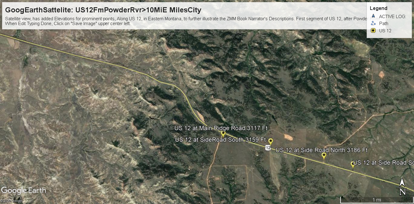
..1) The Powder River at US 12 (2392 Ft), is only (62 Ft.) higher than The Yellowstone River at Miles City, MT (2330 Ft), . This is because the Powder cuts down pretty much to the level of Yellowstone River, some 45 miles down-stream (NE), from Miles City.
..2) It is an observed fact in the Satellite Views (Blue Link Below), that => The increase in elevation (725 Ft,) from Powder River (2392 Ft), >> TO>> US 12 at Main Ridge Road (3117 Ft.), is quite enough higher in elevation to be enough cooler & for enough extra rain, thus creating forested meadows, which the ZMM Narrator Delightfully Reports!! These are the darker areas, as you can see in The /\ Above /\ Satellite View, and can be used to discern relative landscape elevation:
...3) FOR EXAMPLE IN IMAGE/\ ABOVE /\ =>
You can especially see this at the darker green area that is West (left) of the Yellow Colored MapPinPoint Marker followed by words => US 12 at Main Ridge Road.
.. ((EXPLANATION => This is the darker green forest, surrounding the (previous photo mentioned), Microwave Tower, AND likely where the ZMM Narrator reports => The Sutherlands & Chris ..walked into the meadow among the flowers under pines. .. .
..((SIDE NOTE: In the /\ Above /\ Satellite Image, you can see a tan colored area, on North Side of US 12, about a quarter mile, West of Main Ridge Road. Remember where this is, since it explains Previous Photos that have variously mentioned => . a uniform tan slope
a major US 12 road cut
a major uniform dry grass slope, road cut. ))
..4) In the Image /\ Above /\ => Especially notice when you LOOK FURTHER WEST, of this darker green area =>You See By Contrast => You See How Dry & Barren Are These West Facing Slopes => That Go Down To The Hoter Lower Elevation Yellowstone Valley and Miles City, MT. These West Slopes, are apparently barren from a combination of hot afternoon sun, and dry prevailing winds, mostly going East from Super Sun Baked Lower Elevation Yellowstone Valley Areas: What-ever rain falls on these West Slopes, apparently is baked dry, and not available for trees. Seeming that most rain falling, is AFTER cooling in its going up the ridge top.
..5) Another useful way to discern relative elevation, and a characteristic of interest in this Satellite View, are the darker green rain water run-off channels, having lines of darker green trees: Two good examples of darker green trees, in water run-off channels are seen at far right of this above Satellite View.
..6) The above Satellite View, is One of Five Such Segments Showing Satellite Views => With Discussion How LANDSCAPE ELEVATION IS CRUCIAL To => The ZMM Narrative, Last Half of ZMM Chapter 7. =>
FROM Very Dry & Hot At => The Lower Elevation of The Powder River. .
. TO Cooler Forested Meadows At => The Elevation of Top Of Mountain Pass Ridge, 10 Miles East of Miles City, MT.
. .. Click Here For Five Satellite Views => With Discussion How LANDSCAPE ELEVATION IS CRUCIAL To => The ZMM Narrative, Last Half of ZMM Chapter 7.
.**************
.
NOTE: Elevations Are By Free Elevation Finder.
This tool can be used to find an estimate for the elevation of a point on the earth. Click/tap the map or type the address in the text box. https://www.freemaptools.com/elevation-finder.htm
((Contrast the above elevations to Bozeman, MT (4793 Ft), approaching a mile high. ))
Cont Next.Photo => A PANORAMA VIEW Of => The ZMM Narrators
I can see the far side of the valley, away and below.
Photo File = GoogEarth US12JnctMainRidgeRoad=ZmmPioneerPromisedLand+ElevationsSeePprPDR.jpg
Posted 6 July 2020. Revised 12 June & 4 May & 17 Oct & 7 Nov 2020
