ContFmPreviousPhoto => AN ADEQUATE PANORAMA VIEW Of => The ZMM Narrators ..walked into the meadow among the flowers under pines. ..
.7:45 am Tues 13 Aug:
. US 12, Main Ridge Road, Top of the Mountain Pass, ~11 Miles East of Miles City, MT.
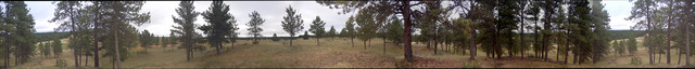
.NOTE: The /\ Above /\ Panorama Photo Shows The SAME CAMERA PHOTOS (And SAME Physical Location), As Previous Hi Quality Panorama Photo, But Stitched. By Less Than Perfect Efforts of Henry Gurr, Using Available APPs.
..AND the /\ Above /\ Photo Is Kept Here, So You may See The Difference.
.Which as you can see in the /\ Above /\, the Photographic Quality is quite acceptable, but The Stitching Microsoft Composite Editor, failed to include one of the supplied photos, and Mid-Panorama can be seen a step-up in the horizon, followed by a step-down by a large tree trunk. Ultimately these faults were caused by Henry Gurrs inadequate Panorama Photographing Technique. The Previous Panorama Photo Stitched & Edit Improved by FlatWorld.com is Far Better.
.**************
.
Keeping an eye on the Micro Wave Tower,
Henry turns onto next side road South, all the time trying to catch sight of a good overlook to the Yellowstone River Valley, to the West. The pavement, turns to red dirt road a mile South, where toward West, is seen a gate & dirt track service access to the Tower: Here, camera in hand, Henry does his own walk into the meadows, among the trees, & pines. , Resulting in /\ Above /\. Panorama.
Seen In This /\ Above /\ Panorama Are:
..1) At first you are looking at the hard to discern Strip of Gray Pavement of US 12, and off to right the Red Dirt Of Main Ridge Road. Then more right is seen some Higher Land of e Pine Forest & Meadows, like those the ZMM Narrator mentions.
.. 2) Then further right, In an opening in the trees, a very slim and high TV Tower, and 4) In 2nd next tree opening, a lower TV Tower, both Towers additionally confirming this area is High-Ground! (at which point notice that the pine needled land slopes down to the right...
..5) Continuing right, through the pines, you can catch sight of Light Colored Plastic Telephone Company Buried Cable Cover Boxes, and beyond, partly visible is =>
.. 6) The Gray Pavement Of US 12, and a view NNE, Horizon overlooking Powder River Valley.
..7) Again you see SAME Strip Of Gray Pavement of US 12, and off to right the Red Dirt Of Main Ridge Road.
..8) Above The Grey Pavement you can see the distant NNE Horizon. Topo maps show this NNE Horizon in this exact direction, is somewhat lower elevation, showing (yet again), we are here indeed on high-ground, and consistent with name Main Ridge Road.
Not far beyond these Cover Boxes, is where Henry found ..overlooking a huge valley and river below, And took the Photos for the panorama 2nd next photo below.
Continue Next Photo. A Satellite View => US 12, Near Top of the Mountain Pass, 10 Miles East of Miles City, MT. With => SOME IMPORTANT LANDSCAPE & ELEVATION & VEGETATION FACTS, TO KEEP IN MIND,
Cont Next.Photo:
Photo File = DSC_0542-0548_stitch=MsoftCompositEditor WlkMeadowPinesRidgeRd10miEMilesCyMT.jpg
Posted 12 June 2020. Revised 12 Oct & 18 Oct 2020.