Continued fm Previous Photo => A LESS THAN PERFECT PANORAMA VIEW Of => The US 12 ZMM Book A Roadside Stop, Locate, MT.
The US 12 Roadside Stop Mentioned in ZMM. Two Miles East of Locate, MT.
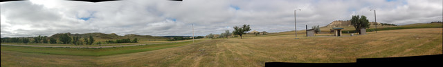
.NOTE: The /\ Above /\ Panorama Photo Shows The SAME CAMERA PHOTOS (And SAME Physical Location), As Previous Hi Quality Panorama Photo, But Stitched. By Less Than Perfect Efforts of Henry Gurr, Using Available APPs.
..AND the /\ Above /\ Photo Is Kept Here, So You may See The Difference.
.Which as you can see in the /\ Above /\, the Photographic Quality is acceptable, but The Less Than Perfect Stitching Of Henry Gurr, using Microsoft Composite Editor, would not allow user to control the Panorama Opening Scene, only stitched 6 of the 7 photos supplied, and has distracting brightness variation. And if properly cropped tor straight top & bottom, too much picture would be lost. These problems ultimately caused by Henry Gurrs inadequate Panorama Photographing Technique. The Previous Panorama Photo Stitched & Edit Improved by FlatWorld.com is Far Better.
.**************
.
..1) The /\ Above /\ Panorama opens with a South View, where looking beyond a stretch of US 12, you see a Typical Tree Covered Montana Valley (Called Archdale Creek) & Distant Mountain Scenery.
..2) .And remembering to click photo several ties to get the biggest view, & possibly use Magnifying Glass, and Using Click&Drag Scroll Bars, continue scroll the panorama right, you will continue to see West-Going US 12, until it disappears over the hill, and thus showing the Narrators more smooth road , that he, Chris & The Sutherlands would have traveled and seen.
..3) Then continue to scroll right, you will see along a Short Exit Road, the grass & trees of the ZMM A Roadside Stop, which is a rather typical Road Side Rest Area.
..4) As you further scroll this Panorama, you see the 3 small buildings: These are the buildings that were there Aug 2019 when the above photo taken.
.a) /\ Above /\ the Center Building, did your vision system (on automatic), fixate on the horizontal multi-colored layers of volcanic dust, & mountain rock? ((Following the INSTRUCTIONS below, for GSV of the US 12 approach to this rest Area, you can see this same Multi-Colored Layered Hill to Right of US 12, at Right edge of the GSV ))
.b) AND at left edge of Center Building a Dark Sign on Wood Poles, which is subject of NEXT PHOTO.
..4) And continued scrolling to right, looking beyond the Rest Area Entrance Road, you see a Typical Montana Scenery to the East. ((Following the INSTRUCTIONS below, for . GSV of the US 12 approach to this rest Area, you can make out parts of the Archdale Creek & Valley to Left of US 12.))
,
INSTRUCTIONS For To See The Actual Approach To => The Narrator's "Roadside Stop" => At Upper Left of Your Browser, "Right-Click" On The "Back Arrow", and ask to Open In A New Tab: This gives you the Previous Photo. Then Scroll down to, And Read, And Click on, the Blue Link.
.**************
.
Date-Line: October 25, 2020. by Henry Gurr.
(ChangesSinceRobertPirsig1968Trip), As Seen By HSG in 2002, 2006, & 2019.)
.Upon all three of my visits to this Locate MT Rest Area, I was not able to find => The ZMM Roadside Rest Areas outdoor drinking fountain. (See ZMM Passage given in Previous Photo.) Nor was I able to discern any evidence of an old drinking fountain or hand well-pump. The 3 buildings you see in The ABOVE Panorama (Aug 2019), looks fairly recent, and much more recent than my photo taken for 2002 ZMM Route Research, which in turn are more recent than the 1968 ZMM Narrator reports in on their travel there July 1968.
.The town of Locate, MT. and the Roadside Rest Area are both marked on my Rand-McNally Road Atlas, as from here ~ 2 miles West on US 12. However: Confirming this, as I went through this part of US 12, I noticed only two houses near US 12, and no other evidence of a town. => The Previous Google Street View (GSV} at Powder River, says this Area is at Ismay, MT.
. However This Satellite View Shows Ismay, MT (Population 19), As Some 25 Miles East And A Bit North Of Where US 12 crosses The Powder River. Click Here.
ALSO THIS SAME SATELLITE SHOWS
..A) All the ZMM Book Towns along US 12, from Miles City, MT to Baker, ND,
..B) AND can see at Center of Satellite View, The Map Location of => The ZMM Narrator's A Roadside Stop, Locate, MT, which in the Satellite View, is ~5 Miles South Of Ismay, Mt, at the center of the Upward (North) Hump Of US 12, seen.
..C) You can also see => The Dark Green Hi Ridge Area at the 10 Miles East of Miles City, MT" AND seen also is the Low Elevation Powder River, mentioned in many Previous Photos. Zoom-In on this Satellite, and you can see there are Ranch Buildings, just North of US 12, on East side of The Powder River.
Cont Next.Photo => Flowers, Volcanic Ash layers, & A 2nd Local History Sign The US 12 Roadside Rest Area Near Locate, MT.
Photo File = DSC_0569-575_stitch=MsoftCompsE US12ZmmRoadSideRestArea LocateMT.jpg
Posted 12 June 2020. Revised 12 Oct & 25 Oct & 5 Nov & 21 Nov 2020.