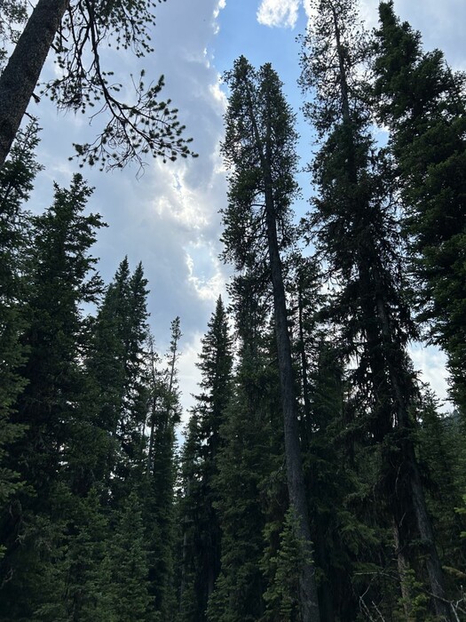
Deeper Into The Dense Forest, Where The Upper Branches Shut Out Direct Sun Light.
Thus Between the Trees It Is Open For Park-like Steady Climbing.
.I see a deer move about two hundred yards ahead and above us through the pines. I try to point it out to Chris, but by the time he looks its gone."
Moving Along The Wide Forested Valley Of Upper Fox Creek, Toward The ZMM Narrators Ridge, Gallatin National Forest, MT. More trail clues for field checks:=> Due to the dense forest canopy shutting our sunlight and the resulting openness between the trees at vision level, the Narrator can easily see a deer at 200 yards.
.. *************************
DATE-LINE: May 17, 2021. by Henry Gurr.
.AN EXPLANATION OF CAPTION EDIT REVISIONS FOR THE NEXT SEVEN PHOTOS.
.As originally posted (2003 to 2010), this Albums Photos & Captions were planned around the original trail conclusion that the "N+C Hypothetical Climb Trail" should have 11 separate photos & captions, one for each WayPt = N+C 14 thru 24.
However, further study revealed that the ZMM Narrative fits into only 3 photos.
And of course, this new conclusion, calls for revisions in the specified WayPt N+C##s, and it was decided to relocate the landscape placements of the WayPt Series N+C 14, N+C 15. A field study should determine a good route from N+C 14 here, on to N+C 23 & N+C 24.
.. *************************..
Instructions To More Clearly See, On A Topo Map, The Separate WayPts (And Contour Lines) For N+C 14 Through N+C 28,
NOTE: AFTER either of the below Blue Links come up, you should Zoom-In (or use Mouse Wheel) to see the N+C WayPoints with increased separation, and more clarity..
A) First With TopoZone Map:
Right Click & Open In New Tab, To View A Close Up Topo Map.
B) Second With CalTopo Map:
..CalTopo Is Excellent For Working With Topo Maps, GPS WayPoint Data, And To Study & Explore Of Mountain Climbing Routes, Especially In Gallatin National Forest (GNF), South Of Bozeman, MT.
CalTopo, an on line platform, is shown here because, again and again, I keep finding more and more uses for its abilities!
CalTopo is excellent for working with Topo Maps, GPS WayPoint Data, and to Study & Explore Mountain Climbing Routes, Especially In Gallatin National Forest (GNF), South Of Bozeman, MT.
Moreover, CalTopo is also good, for changing GPS Waypoint Data.gps to .KLM, for loading WayPoints into Google Earth!
. Use Caltopo To Find N+C WayPoints & Elevations. Right Click And Open In New Tab.
. *************************
(Photo = IMG_0032 Resize1000x1333.jpg ...... ZMM Page = 207 ...... Photo Simulate WayPt = N+C 14 8400 ft = 7.4 mi fm DeWeese.)