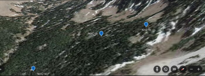
A GoogleEarth View Of Upper Fox Creek Canyon, Showing Waypoints N+C14 15-16, For The Most Likely Gallatin National Forest, Mountain Climb Route That => Fits The ZMM Books Narrator + Chris Climb Narrative. View Looking ~Southeast.
Upper Fox Creek Canyon, Gallatin Gateway, MT.
REPEAT FROM PREVIOUS: VIEWING NOTES:
A) The GoogleEarth photo image you see above, shows the Mountain Landscape of the next ONE photo, but since it is a 2D Image it is difficult to perceive any 3D.
B) To REALLY SEE the 3D in these Mountain Landscapes, study Right Click Here And Request New Tab. Then GoogleEarth will load in an extra Browser Tab. After several minutes to load, at Lower Right, ClickOn 2D, to bring up 3D, then ClickDrag, to Best See the 3D.
*************************
(Photo = ScrnCapt GoogEarth CottnWoodCyn N+C 14 15-16.jpg...... ZMM Page = 207 ......WayPt ~= N+C 14 15-16)