Leading To The Orr Hot Springs Resort, A Google Street View (GSV) Screen Capture Photo, Shows Their Bridge Over The South Fork Big River (SFBR).
This Stream Is Shown on Maps as South Fork Big River, And In This Area Of California, Is Along The Orr Springs Road, Which Is The Same As The Comptche-Ukiah Road => .
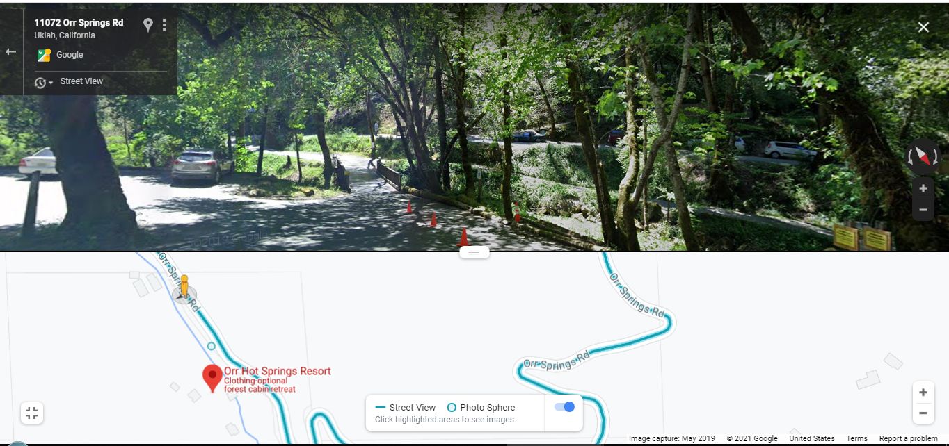
Look VERY Close (To Right Of Orange Cone At Base Of Tree) => And Looking Further To Right, In The Sunlighted Area, You Can Discern The Slope Down to The Edge Of A What Must Be A Medium Sized Stream. But The Water Is Barely Discernable.
The NEXT GSV Photo Shows A Better View Of The Water Of This Stream.
[ . "What do you see?" I ask. .. "Its all different."
We head into a grove again, and he says, "Dont you get scared?"
"No, you get used to it."
I begin to feel drowsy and in a small ravine ahead I see a turnoff and a picnic table. When we get to it I cut the engine and stop.
"Im sleepy," I tell Chris. "Im going to take a nap."
"Me too," he says. ]
We sleep and when we wake up I feel very rested, more rested than for a long time. I take Chriss jacket and mine and tuck them under the elastic cables holding down the pack on the cycle.
Its so hot I feel like leaving this helmet off. I remember that in this state theyre not required. I fasten it around one of the cables.
."Put mine there too," Chris says.
."You need it for safety."
."Youre not wearing yours."
."All right," I agree, and stow his too." (Cont Next)
************************
.**************
.
Orr Hot Springs Resort, The Most Likely Place for The Narrators 1968 a picnic table
..A) ~32.1 Road Miles East of Mendocino, CA and.
..B) ~12.2 Road Miles West of Ukiah, CA.
A NOTE RE /\ ABOVE /\ PHOTO:
.You can easily make out the Cut of the Stream to the LEFT of the Bridge. Continue looking to RIGHT Side of the Bridge, and you can make out more of the Cut Of The Stream in the Sunny Areas between the small trees.
As Was Stated In 4th Previous Photo => Despite His Best 2002 ZMM Route Research Efforts, Henry Gurr Has No Photos Of Narrators Picnic Table Or Narrow Ravine.
.Having no other suitable Photos, Google Street View (GSV), Again Comes-To-The-Rescue, as you see in the /\ Above /\ Photo, the Next Photo, and Other Photos in this Album.
.************************
The /\ Above /\ Photo Is/Was A Screen Capture From => A Google Street View (GSV), Image May 2019.
You can do own GSV Drive on => Google Street View (GSV) To Do Your Own Study Of => What Can Be Seen From The Road, You Can . Do A GSV Drive, In Either Direction.
.Click on Blue Link above and => You can GSV Drive, in either direction, and see that this Valley OVERALL, might reasonably fits definition of Ravine => a deep, narrow gorge with steep sides.
And, In Addition => You Can GSV Drive, Further East And Go Around 2 Switchbacks, At Which Point =>
. Click Here, And In This GSV, You Will See A Nice Ravine, In The Distance To The South Of SFBR. This Might Well Be The ZMM Narrators Narrow Ravine.
************************
A Search On Bing Or Google Finds 100s Of Photos Showing That => Orr Hot Springs Resort Is A Really Nice Place! AND A Hidden Retreat Only Three Hours North Of San Francisco For Only $50!!"
If you Bing or Google
.Orr Hot Springs Resort Mendocino County California
, In the results, you will find mentioned sites that have Photos & Reviews. And you will see where to Click to See Photos
a) On Google, a click All Photos will bring up 45 really nice Photos.
b) On Bing, a click All Photos will bring up 47 really nice Photos.
Of course, a few of the photos are the same.
Orr Hot Springs Resort.
https://www.orrhotsprings.org
CONTACT-US EMAIL: orrreservations@gmail.com (please include a phone number at which you can be reached).
13201 Orr Springs Road
Ukiah, CA 95482
************************
.As You Will Read In The NEXT Photo You Will Be Able To =>
A) Judge For Yourself Whether The Orr Hot Springs Resort, Is Practically The Only Place That Fits The Narrators Descriptions => Picnic Table Or Narrow Ravine.
B) ALSO See The Above Mentioned Ravine In A Topozone Map.
*************************
(Photo = GoogStVu FootBridgeCrossSForkBigRv}OrrHotSpringsResort11072OrrSpringsRdUkiahCA.jpg ...... ZMM Page = 371 ...... WayPt = Is At /\ Above /\.Photos GPS Coordinates given In the Blue Link, Or Alternatively At Top of The AboveMentioned TopoZone Map. )
