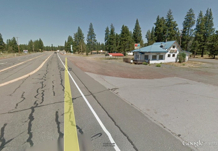
Lee Glovers Photo From An Old Google Street View, Shows The Rapids Cafe'.
This Is Very Likely The Oregon Roadhouse Restaurant, That The ZMM Narrator Describes Along The Eastern Side Of Klamath Lake, OR.
We pull in for lunch at a roadhouse which belongs to this era too. Wooden frame badly in need of paint, neon beer signs in the window, gravel and engine drippings for a front lawn. .. Inside, the toilet seat is cracked and the washbowl is covered with grease streaks,
. (Cont. Next)
At intersection of road from Crater Lake, Rt-62, with US-97, along the Eastern shore of Klamath Lake, OR. My imagination failed me in my 2002 search for the Narrators Klamath Lake Road House!! My 1964 Rand McNally Map shows, the towns along the waters edge of Upper Klamath Lake. These are Modoc Point, Algoma, Wocus, Pelican City, and Klamath Falls. (Pelican City is now a Northern Suburb of Klamath Falls.) I was expecting all these towns to be along the lake waterfront, and at one time they probably were. I remember beach type homes along the lakefront when I came through here in 1989.
It never occurred to me that I was on a new highway a considerable distance away from the towns the Narrator may have gone through. I now realize I was misled by my memory of my 1989 trip, becase I had the quite reasonable memory expectation that the towns were at the waters edge. Since I was traveling at the waters edge, I kept going under the belief that I would find these towns per my memory. But were these were merely ghosts in my mind?
A likely reason. I failed to see the waters edge (and the towns) because the water had been moved and I did not realize this! Since my1989 trip, a new dyke system may have been built far from the original shore. This allowed the water to be pumped out, and thus the creation of new agriculture land. See Topozone maps 2nd photo previous. Also see the other links on the previous photo, for considerable discussion of how a largest percentage of the original Upper Klamath Lake has been claimed for agriculture!!
I hypothesize that originally these towns were situated by the lake edge marshes. And originally the main N-S road curved along the lake edge to go through them. The Topozone maps (previous photo) shows extensive dikes and pumping stations. To make dry farm land, these dykes apparently, have moved both the waters edge and the highway!! Consequently the new & straightened US-97 is some 3/4 mile East of Algoma and Wocus. Moreover, on the approach to Klamath Falls, Rt-57 travels on a huge dike (at lakes edge) for a considerable distance.
**************************
Click Here. To See A Google Street View, Showing A Casino & Truckstop Refueling Station, Where Was Formerly The Rapids Cafe'
ATTENTION: AFTER This Google Street View comes up => At lower left, click on Box to expand the Strip Map. Then ClickDrag the Strip Map, to the Right, until you can see Klamath Lake at Left.
**************************
The NEXT Photo Explains How I Request Help For Getting Photos To Fit The Above ZMM Passage.
As you will learn ZMM Route Researcher Lee Glover, Successfully Found The Rapids Café Shown In The /\ Above /\, And Next Two Photos.
*************************
(Photo = FmLeeGloverEml130527 ...WritingKlamath 2009FraGrab=Google Earth-old Rapids Café.jpg..... ZMM Page = 313 ..... WayPt = 383i2 ~4200 ft)