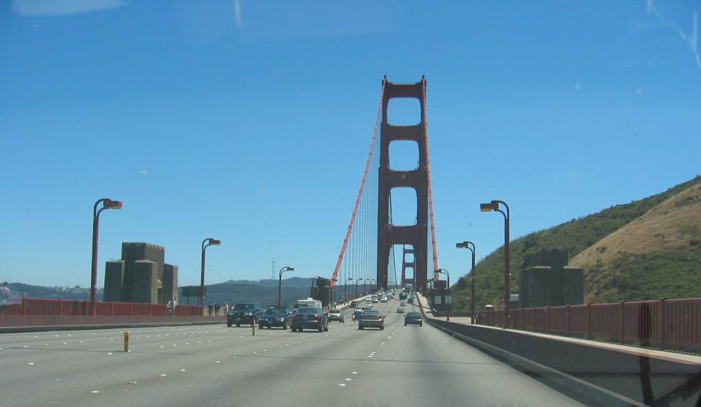
On The Approach Ramp Of The Golden Gate Bridge, San Francisco Harbor.
[ but there is a feeling now, that was not here before, and is not just on the surface of things,
. but penetrates all the way through:
. ]
Weve won it. Its going to get better now. You can sort of tell these things.
End Chapter. 32 & End of ZMM Book.
Next Photo: A ZMM Passage from the Afterword, Bantam Paperback Edition.)
Southern Tip of the North San Francisco Peninsula, Golden Gate Bridge, Sausalito, CA.
*************************
DATE-LINE April 16, 2023. CONCERNING THE /\ ABOVE /\ PHOTO BEING PART OF A 360 DEGREE PANORAMA: :
.You will notice that the /\ ABOVE /\ Photo is at WayPt = 489x, where the x means an 8 Photo Panorama was taken here
. Right Click And Select New Tab, To Read => Viewing 360 Degree Full Circle Panorama Photos For The Remainder Of ZMM Part 4 Album:
After this Photo & Caption comes up, you can read Panorama Photo Viewing Instructions, and find link in-order-to view, my 360 Deg Panorama at WayPt = 489x.
If you like this Panorama, please send an email. HenryG__USCA.edu.
************************
Please Be Aware That Henry Gurrs Following A) & C) Google Earth Projects Are Completed, And Ready To View As Follows =>
INSTRUCTIONS: For best enjoyment of these below 3D Google Earth Views, AND for maximum understanding at each Blue Pinpoint, you should 1) Have the ZMM Route photos you are looking at, AND CONCURRENTLY 2) Have either of the Blue Links below => on a separate Computer, or Cell Phone screen.
You will find additional specific instructions in each of the Google Earth Projects.
A) GoogleEarth 3D Viewing Of A Mountain Climbing Route of Chris and the Narrator, In The Gallatin National Forest (GNF) South of Bozeman, MT. This Route Fits Mountain Climb Narrative, In The Book Zen and the Art Or Motorcycle Maintenance (ZMM) by Robert Pirsig.
INSTRUCTIONS: AFTER This Page Comes Up => Please Scroll Down To And Read BOTH ABOVE and BELOW THE FOLLOWING WORDS =>
If You Don't Have The Resources Or Time To Climb The Trail, Or Even Drive There!
FROM YOUR COMPUTER (WITH A FAIRLY FAST INTERNET), YOU CAN GOOGLE-EARTH, CLICKDRAG VIEW THE ENTIRE => "N+C Hypothetical Climbing Trail". (Also, you will see the needed Google Earth Link.)
B) GoogleEarth 3D Viewing Of ZMM Book Route Along Montana & Wyomings Beartooth Highway From => ZMM Town Of Laurel, MT To Highest Parts Of The Beartooth Plateau (~11,000 ft Elevation). And then To East Gate Of Yellowstone National Park, Go By YNPs Mammoth Hot Springs Calcite Formations, And Then To ZMM Town Of Gardener, MT.
ATTENTION: This Is A JUST STARTED NEW Google Earth Project, And As Yet Has NO CONTENT. If you want me to hurry up and get some content here, please send email to HenrySGurr@gmail.com
This Currently Has No Content, But Will Be Ready For Viewing ASAP.
C) GoogleEarth 3D Viewing of ZMM Route => Starting this WayPt = 453w seen in The /\ Above /\ Photo. And then continuing
Along the Mountainous California Coast To > Mendocino, CA. Then Inland To Ukiah, CA. And Then Via US-101 > San Francisco. Click Here.
*************************
(Photo = 118-1825c.... ZMM Page = 373 .... WayPt = 489x ~0150 ft)
