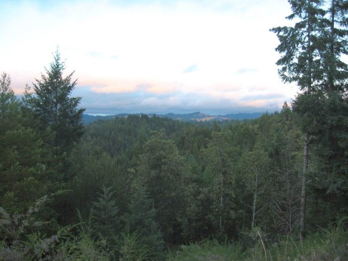
Looking East, Ukiah is 21 Miles Away, Beyond Those Distant Mountains.
The Very Slight Orange Is From Sunset Light, As Seen Next Photo.
EXPLANATION: As We Travel East On This Backcountry Comptche Ukiah Road Towards The ZMM Route Town Of Ukiah, CA =>
We Leave Melbourne, CA (WayPt = 468w ~0435ft), And The Road Does A Twisty Climb (~+400 Ft) To A Ridge Top (WayPt = 469w 1226 Ft Elevation), Where The /\ Above /\ Photo Came Into View!
Google Map Gives Address as Ukiah, CA.
..A) ~32.1 Road Miles East of Mendocino, CA and.
..B) ~12.2 Road Miles West of Ukiah, CA.
. This TopoZone Map Clearly Shows The Hillside Climb To The Hill Top Location Of /\ Above Photo => RIGHT CLICK AND SELECT NEW TAB
And AFTER the Map View Comes Up, You Will See a Clutter of Adverts That Are Impossible To Eliminate. => YOU BEST SHOULD =>
.Use Scroll Bar At Far Right => Adjust Green Topo Map Until You See JUST BELOW The Plus&Minus Upper Left. => A ClickOn For Full Screen. Click on it, and Adverts Will Be GONE.
.Then use Plus&Minus To Zoom. You can Click&Drag Map In Any Direction, to See More Off Your Screen Edges.
Keeping The Setting For Full Screen, Please Know That => My WayPt = 469w 1226ft, Is In The Exact Screen Center, At GPS Coordinates => Degree Latitude = 39.22862 & Degree Longitude = -123.49605.
Now, because TopoZone Maps do not have any way to mark screen center, you should at just below center, look for the darker contour line at 1460 ft elevation, that goes all around a hilltop: And just a bit above the hilltop, is my WayPt = 469w 1226ft: Of course this WayPt is by the Comptche Ukiah Road, which on this map is marked by two closely spaced lines, so it looks darker & wider than other lines.
If you follow this road line down (South), and then zig-zag to left (West), and then approx. 45 deg moving to upper right (Northwest), you see the road has come up the hill side, which is above (North) of Johnson Creek. This fits the Twisty Climb description given in bold above.
Now, going back to center screen, and If you follow this road line trending generally to the right (East), you see the road does a lot of zig-zags, as it goes gradually down the hill side, to an elevation of 600ft, and soon thereafter drops into the valley of the East Fork Big River (EFBR), which is the topic of the THIRD & FOURTH next photos.
Continued following both road and EFBR, these will go by Orr Springs, the topic of the FIFTH & SIXTH next photos.
DATE-LINE: April 11, 2023. by Henry Gurr.
If you read the above TopoZone paragraphs AND see these features on the TopoZone Map, you will realize how useful these topo maps are.
In my experience in using TopoZone Maps, it is far easier and faster to see elevations and changes in elevation than say Satellite Views. And even better than Google Earth Pro (installed on your computer version), because even in their 3D Display, is often too much obstructed by trees, to see elevation changes well enough to adequately identify hill tops, streams or rivers.
My additional experience in using TopoZone Maps =>I was editing captions the series of ZMMQ Gallery you have been looking at, and discovered the text did not say well enough the location of above WayPt = 469w. I extensively tried Google Satellite Views and Google Earth Pro, but neither gave what I needed.
Finally, after hours of frustration, I used a TopoZone Map showing area of Comptche, CA and followed the two closely spaced lines to the SE until I found => The road that came up the hill side, which is North (above) of Johnson Creek,. which was followed by the zig-zag road: And when I saw the darker contour line at 1460 ft elevation, that goes all around the hilltop, I knew I had successfully found my lost WayPt!! This is because the road shown on TopoZone, fit the above Bold and fit my 2002 memory of the road leading up to where I took the /\ Above /\ Photo.
Thus in summary, and as a matter of fact, it was a TopoZone Map, that enabled me to find the map location of the above mentioned WayPt = 469w 1226ft.
AND also, as a matter of fact, it was extensive studying a TopoZone Map, that enabled me to find the map location of the ZMM Narrators => in a small ravine ahead I see a turnoff and a picnic table .. Earlier study using Google Satellite Views and Google Earth Pro failed.
*************************
. RIGHT CLICK AND SELECT NEW TAB => After Satellite Map View Comes Up, You Will See The ZMM Route From Comptche, CA, Going East To (the North of) Montgomery Woods State Natural Reserve. ClickOn The Plus&Minus To Zoom. You can Click&Drag Map In Any Direction, to See More Off Your Screen Edges.
.After this Satellite View comes up (may have to ZOOM OUT to see), The Larger Red Pinpoint Marks Henry Gurrs /\ Above /\ Photo location at WayPt 469. You can see & read Comptche Ukiah Road, and see the Twisty Climb to the Red Pinpoint
Forthcoming Photos will mention Orr Springs Road, which is the same road as the Comptche Ukiah Road, with just a name change. Of course this road goes by Orr Hot Springs Resort, a topic mentioned in previous and following photos.
*************************
(Photo = 117-1727b ...... ZMM Page = 371 ...... WayPt = 469w 1226ft )