As Was the Case Of The Narrator, I Also Could Not Find Any Motels Or Hotels In This Town, Even After An Extensive Search.
Thus, Confirming (Again), The Factual Accuracy Of ZMM => The Discussion Below Has A Full Explanation, As To WHY There Are No Motels Near This Fortuna, CA Freeway Exit.
[a bright sign of a filling station far down the street.] .. Its open. We pull up and go inside. The attendant, who looks Chriss age, watches us strangely. He doesnt know of any motel. I go to the telephone directory, find some and tell him the street addresses, and he tries to give directions but theyre poor. I call the motel he says is closest, make a reservation and confirm the directions. .. In the rain and the dark streets,
. Cont. Next.)
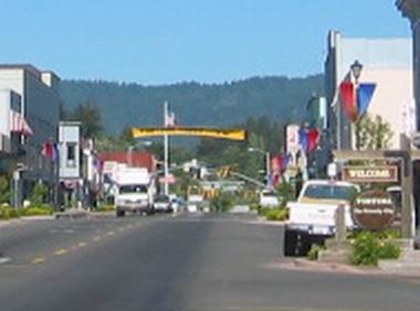
Stop sign, Business District, Fortuna, CA.
DATE-LINE March 22, 2023 by Henry Gurr: Concerning The Difficulty Of Finding Any Motels At The Fortuna, CA Exit From US-101 Freeway.
Both the ZMM Narrator in 1968 and I in 2002, had great difficulty finding any motels near this freeway exit. I remember seeing somewhere that this was due to a disastrous flood in the Fortuna, CA area.
So just now I did a Google Search for disastrous flood in the Fortuna, CA. And found that Click Here To See Satellite View => How Fortuna, CA. Is IN The Flood Plane Of The Eel River.
From the above Satellite View, you can see that Fortuna, CA is right beside the Eel River, exactly IN the flood plane, with practically no elevation above it.
AND, of course this could have destroyed most of the motels, and reasonable that none were rebuilt 4 years later when Author Robert Pirsig came through in 1968.
This makes lots of sense as you read the 1964 Flood Article below. This 1964 Flood Article is among many such reports Google Search found. =>
The Thousand Year Flood of 1964.
By Clay Mcglaughlin. Published: December 18, 2014, & update September 7, 2018.|
On Christmas Eve morning ,1964, the rampaging Eel River had ripped apart the Paul Mudgett Bridge at Rio Dell. At lower left is the Eel River Sawmills log deck.
This December marks the 50th anniversary of the Thousand Year Flood in Northern California, which officially began on Dec. 21, 1964 reaching its peak on Dec. 23 of that year and continued until early January 1965. Striking nine years almost to the day after a 1955 flood that was called the disaster of the century, the 64 flood was caused by a deadly combination of weather events that dumped massive amounts of snow in the mountains, followed by warm rains that melted the snow and inundated local watersheds in a matter of hours.
Prior to the main storm period, Dec. 19 through 25, minor rain events of November into early December had saturated the ground and increased the flow in the local rivers. In mid-December, a strong high pressure system was located between Hawaii and Alaska.
Around Dec. 19, the high pressure system weakened, allowing follow-on weather systems to move across the Pacific Ocean at successively lower latitudes before turning to the northeast and moving towards the west coast. A storm track 500 miles wide extending from near Hawaii to Oregon and northern California was established, wrote Reginald Kennedy, service hydrologist at the Eureka station of the National Oceanic and Atmospheric Administration/National Weather Service.
The combination of this very moist warm air, strong west-southwest winds, and orographic lift of the mountain ranges oriented at nearly right angles to the flow of the air resulted in heavy rain from Dec. 21 to 23. Today we use the term Atmospheric River to describe this type of weather phenomenon.
According to Kennedys research, during peak precipitation Whiskeytown Reservoir and Richardson Grove State Park reported more than 11 inches of rain in 24 hours. A total of 15 inches was reported at Ettersburg, 22 inches at Standish-Hickey State Park, and 17 inches at Gasquet.
The flood cut a huge swath of destruction across the North Coast, killing 29, causing millions in damage and cutting off entire communities from the outside world for months. Click Here To Read Whole Article With Photo Of Flooded Eel River And Destroyed Bridge.
The Hundred Year Flood of 1964.
Click Here To Read Whole Wikipedia Article With 3 Photos Of Flooded Lands And Bridge. Also a Map of California showing the 34 counties declared disaster areas during the flood. The six red counties sustained more damage than the other 28 counties combined.
NOTE:
AFTER the above-mentioned Satellite View comes up, you can also see (at bottom right of center), the comparative location of the small town of Redcrest, CA, which is some 25 miles further South. As you will see, this is the most likely location of Chris and the ZMM Narrators Motel.
*************************
(Photo = 116-1639cz2.0 ...... ZMM Page = 359 ...... WayPt = 441aw 0061ft)