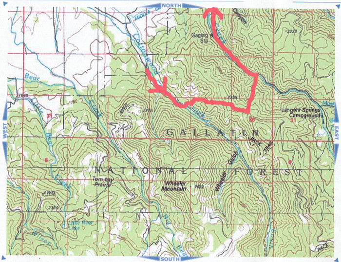
A Topo Map Of The Approximate Route Climbed By Robert Pirsig & Son Chris, On or around July 17, 1968.
.This Hike Trail Map Was Sent To Me Henry Gurr, By Author Robert Pirsig In Response To My =>
.Many, Many Questions About Various Hypothetical Mountain Hiking Routes, That Fit the Descriptions Given By the Narrator In the Book Zen and the Art of Motorcycle Maintenance (ZMM).
.I Henry Gurr, have long wondered what actual mountain Climbing Route was followed by Robert Pirsig and son Chris. And wondered how close this was to the ZMM Narrators descriptions of their mountain climb after they left the DeWeess's at the Start of Chapter 16.
.This topic was included in a long series of letters between Robert Pirsig and myself in Dec 2006 & early 2007.
Here Is A Detailed Synopsis Of => Author Robert Pirsigs Discussions Of His Actual Mountain Climbing Route With His Son Chris.
A) In my letter to Mr Pirsig Dec 12, 2006, I asked =>
..What was your mountain climb route in the Gallatin National Forest? See Link below for WebMaps showing my Hypothetical Climb Route (WayPts N+C 01 thru N+C 33). Note that the 4th map is a "zoom in" enlarged portion for the climax climb to "the ridge". Two alternate climb routes are also shown on the map. (These have numbers N+C 34 and higher.) Could you comment on the probable accuracy of this route, as relates to what might have happened in 1968?
B) In his reply Dec 27, 2006 Mr Pirsig said =>
..I'm attaching maps of the route from Prineville Junction back to Minneapolis and also the route climbed from Cottonwood Canyon. ((<\ Above/\.))
C) In answer to my questions, Mr Pirsig Jan 4, 2007, stated =>
.."Your guess is as good as mine about the mountain route we took. I remember that the descent to the Hyalite canyon was extremely steep. Also Chris left his jacket behind. If anyone finds a brown cloth jacket with darker brown imitation leather sleeves that looks 38 years old he will have found our route. If it is still there it is probably down lower than the route you took. The ridge was dry then too.. We took our water with us. All this research into the ZMM route makes me feel prehistoric, but I suppose it helps the book move along."
D) In my reply letter to Mr Pirsig Feb 7, 2007, in part, I said =>
To help you I have included six [paper] printed photos made by GoogleEarth. These images show views of Cottonwood Canyon which are consistent with the ZMM Narrative climb route to "snow". A cover page attached to the photos has a full caption, with relevant ZMM passage, for each photo. These descriptions include why I think the trail shown fits the ZMM Narrative.
. After you study the printed photos, could you comment on the general adequacy of this route shown in the six photos. Does the route fit the ZMM Narrative?
E) In my continuation letter to Mr Pirsig Feb 21, 2007, with more concerns I said =>
I guess am a bit disappointed to hear that you and Chris only went about 1/2 mile into the forest. This is because the ZMM Narrative would lead us to believe your trail really made a lot of progress up to that snow. Am I to conclude that there is a considerable difference between the ZMM Mountain Climb Narrative and the route you and Chris used to cross over to Hyalite Canyon from Cottonwood Canyon? Are we to conclude that certain portions [especially physical scenes] of the ZMM Mountain Climb Narrative, like the Bad Storm of Chapter 3, were fictional parts of the book? RP REPLY: "YES".
.All this leaves a residual question: How well does my hypothetical mountain route fit with the ZMM Mountain Climb Narrative? Would you care to comment on this?
RP REPLY: "IT DOESN'T FIT".
.Any way I hope you enjoyed the photos and re-acquaintance with Cottonwood Canyon, Fox Creek, and Mt. Blackmore. Did you use Google Earth to "fly" up the canyon to the mountain?
RP REPLY: "YES". ((<< Mr. Pirsigs replies were written on paper copy of my letter, and sent back to me.))
..****************..
From all this, I began to understand that the route actually followed by Mr. Pirsig and Chris on or about July 17, 1968 was considerably different from that we read into the ZMM Narrative. To repeat above sentence: Mr. Pirsig says "YES" to my question => Were the physical scenery descriptions of the Narrator and Chriss Mountain Climb (in Chapter 16 thru 21) largely fictional?
. Click Here => AFTER This Link Comes Up => You May Read, In Full, My Correspondence With Author Robert Pirsig, 2006 thru 2008.
..****************..
You may study my "Narrator and Chris (N+C) Hypothetical Climbing Trail Topo Maps" chosen to fit the ZMM Narrative in the NEXT FIVE photos.
/\ Above /\ Topo Map Photo Shows => A Ridge between Cottonwood and Hyalite Canyons, ~ Two Miles Into Gallatin National Forest, MT.
*************************
(Photo = ScanRobertPirsigColorMapMtClimbGalatinNF ...... ZMM Page = 227 ...... Photo at WayPt = NA)