Friday, July 19, 2024:
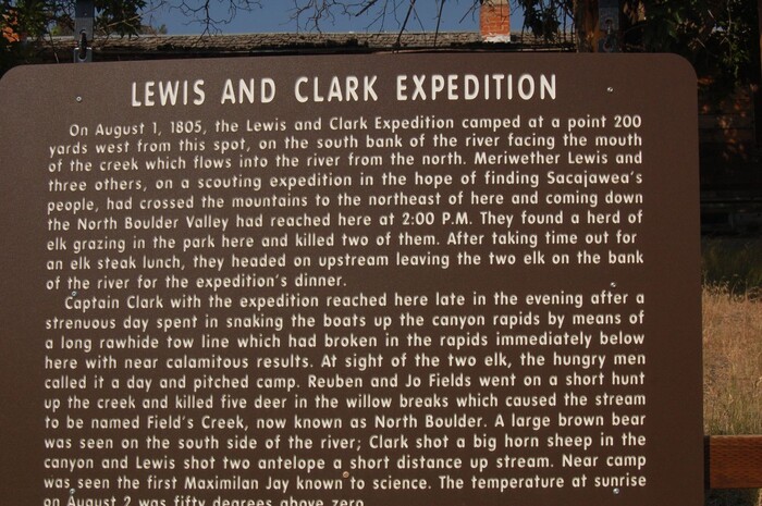
HISTORICAL MARKER: Captain Meriwether Lewis of The Lewis and Clark Expedition Camped Here.
.This Camping Was After Returning From A Side Expedition That Was In Hopes Of Finding Sacajaweas People.
The ZMM Narrator says =>
. canyon of whitish-tan rock, past some Lewis and Clark caves.
.
About A Mile East Of Town Of Jefferson Island, MT, And About 1000 Feet East Of The Jefferson River, At LaHood Park, MT. GPS = 45.8531201,-111.9221256
..****************..
The /\ Above /\ Historical Marker Gives Important Evidence That =>
.The Lewis and Clark Expedition Near This Location, Was On Its Way To Find A Passage Further West, And Eventually Find A Northwest Passage To The Pacific Ocean By Way Of The Columbia River.
EXPLANATION: The Jefferson River Must Be An Important Part Of The Lewis and Clark Expedition, Main Exploration Route Because =>
...A) Of the 3 available rivers, the Jefferson leads furthest West, and
...B) Why else would => The Expedition Crew, exert such great effort, at such great peril, to bring their boats up the many Rapids of the Jefferson River. (Boats being their main transport, the Expedition had used boats ever since their start at St Louis.) Thus
..C) From here at LaHood Park, MT, they could continue to effectively use boats, on the Jefferson, for another ~30 mile further West. And upon return, of course, 30 easier miles, going downstrean, back East, & back home.
. On this Lewis and Clark Expedition Map, a ~90% portion of the Expeditions use of the Jefferson River, is shown as the Red U Shape , to left of words Clarks Return. Click Here.
..****************..
The North Boulder River, Mentioned In The /\ Above /\ Lewis & Clark Historical Marker Sign, Can Be Seen In Satellite View, Blue Link BELOW =>
In This Satellite View, To See The North Boulder River => Find Rt2 Going North From The Red PinPoint. Follow Rt-2 North To Where Rt-2 Swings Around To The West And Starts To Run Parallel To I-90.
.Zoom-In, And Look Closely To See There Are Extra Concentration Of Trees & The Curves Of A River. This Is Where I-90 Has Two White Rectangles, Indicating Bridges Over A River: THIS IS The North Boulder River.
. RIGHT Click & Select New Tab To See A Google Satellite View Of The Location Of The /\ Above /\ Photo. This Will Help You Know WHERE Are Located Important Landscape Features, Discussed In The 8 Photos Hereabouts In This Album.
AFTER This Satellite View Comes Up, Please Notice =>
..A) Upper Left Of Center, Jefferson Island, MT, and a bit further right, LaHood Park, MT and
..B) At right off Satellite View, The White Rt-2 Highway Markers, which mark the road from Three Forks, MT and from there, follow the Jefferson River. ((With the exception that, the Line for Rt-2 LEAVES the Jefferson River Valley (look closely) going North from LaHood Park, MT.))
.,C) Red Pinpoint marks Location of /\ Above /\ Photos, taken at Henry Gurrs 2002 ZMM Research WayPt = 235.
..D) North of Jefferson Island, MT, see where Rt-2 runs by I-90. Zoom-In, ClickDrag, and look closely to see I-90 has bridges over a river. This is the North Boulder River, which is mentioned in The Lewis & Clark Historical Marker Sign, above Photo.
..E) At center right, Lewis and Clark Caverns State Park.
..F) Zoom-In and then ClickDrag View up until you see the South-Most-Curve Of The River. Above the river, and by the highway, you see a Dark Spot. This is the Unusual, Large Lone Tree mentioned, and seen in my 2002 ZMM Route Research Photos ( = 109-0931 + 109-0932sc). AFTER this comes up => Use Link SECOND Previous Photo, which says And AFTER The 18 Small Photos Page.
..G) The Lone Tree of F) above, marks a bit further West from where my previously seen 3 2002 Photos were taken at 2002 WayPt = 232.
..H) NOTE: This SAME Lone Tree, is shown in a Google Street View, FOUR Photos previous.
Click Here For More Information & Photos Concerning Thie Historical Marker. .
NEXT PHOTO shows and discusses The Historical Marker for the LaHood Hotel, which is adjacent to the /\Above/\ Photo.
*******************
File = DSC_0507 Resize602x400.jpg
Click Here For A Google Street View, Of The /\Above/\ Historical Marker AND The LaHood Hotel Historical Marker, ln Front Of The LaHood Hotel Building & Site Overall View. .