A VERY INTERESTING SCALE MODEL =>
...OF THE TOPOLOGY OF THE THREE FORKS OF THE MISSOURI RIVER.
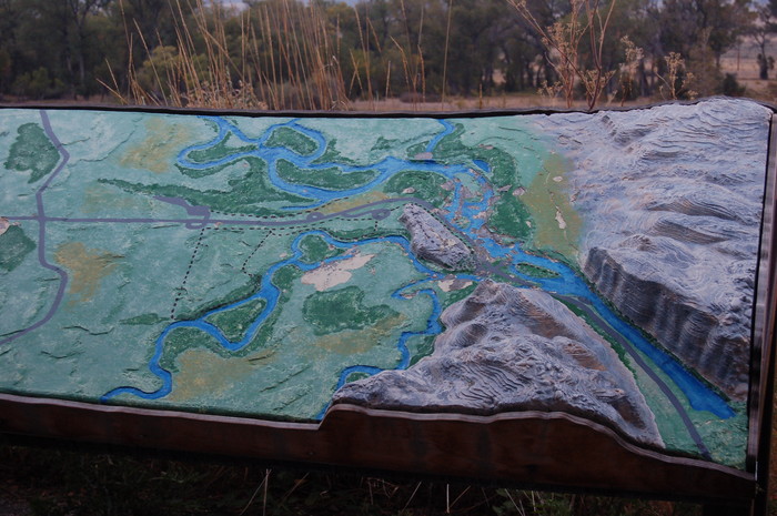
.At Lower Right => You Can See The Cut In The High Mountain Ridge That Forces Channels These Three Rivers Into One Channel!
.To See => A Photo OF This Scale Model, And Its Surrounding Three Rivers Area, Click Here. => The Three River Headwaters State Park, Three Forks, MT.
Above Scale Model Is At => The Three River Headwaters State Park, Two miles Northeast of Three Forks, MT. As is true for all Tourist Attractions this Park Is UN-mentioned in ZMM.
.And, as discussed in Previous Photo & Illustrated in the /\ Above /\ Photo => ~2.5 Miles Northeast of The town of Three Forks, MT, is where these three rivers are forced together into a narrow, steep-banked Cut In The Mountain Ridge, to form the Missouri River which then flows North to Helena, MT..
.The Three Rivers are the Jefferson (from West), the Madison (ffom Southeast) and the Gallatin (from the East).
.Moreover => Three Major Highways travel from the Three Forks Region, each following one of the Three River Valleys upstream.
..****************..
AN EXPLANATION OF => AUTHOR POBERT PIRSIGS ZMM BOOK DISCUSSION At Three Forks
The ZMM Narrator, After Long Search, Eventually Discovered =>
the most eminent scientific man of his generation
. Jules Henri Poincaré, about whom the ZMM Narrator says => When you live in the shadow of insanity, the appearance of another mind that thinks and talks as yours does is something close to a blessed event. Like Robinson Crusoes discovery of footprints on the sand. ..
. Click Here To Read Full Text of Book =>
. Foundations of Science and
. by Julius Henri Poincaré.
.This is the book widely quoted from by ZMM Narrator, in ZMM Chapter 22.
EXPLANATION OF=> "METAPHORIC-BRIDGE-CONNECTIONS IN ZMM BOOK "=>
.In the ZMM Narrators discissions, you find there often Is => A Bridge Between The Narrator's Chautauqua (In this case, a Lecture on Three Geometries, and the Travel Narrative (Descriptions of Three Rivers & Three Forks Town).
.Here, Author Robert Pirsig, Metaphorically Connects these THREE Rivers, TO => The fact that to travel West from Three Forks Area, the ZMM Traveler must choose ONE of the THREE Rivers. This is metaphorically significant to the Narrator, because he, like a 3 Geometries Mathematician, must choose to follow ONE of the THREE => In this case, choose the ONE River, the Jefferson River, to go upstream into the rich, fruitful valleys & mountains, to the West.
..****************..
To Learn More About Metaphoric Bridge Connections, Right Click & Open In New Tab To Go To => Why Is Robert Pirsigs ZMM So VERY VERY VERY Factually Accurate? AFTER This Page Comes Up. Scroll Down To and Continue Reading At => Metaphoric Bridge Connection.
.**************
Also The NEXT PHOTO Has A Whole Lot More Discussion Re Poetic/Metaphoric Use Of Town Names.
..****************..
NEW TOPIC:
The Previous Panorama Photo Dramatically Showed How => The Geography & Topology of the Three Rivers that are forced to join to make Three Forks Of The Missouri River:
However, Unfortunately, The ZMM Route, Coming From The East, Goes Directly Into Three Forks Town, Without Much Allowing The Pirsig Pilgrim To Actually See These Rivers, Or The Place Where They Actually Flow Together, To Form The Missouri River.
.This Inability To See => Is Because The Land Is An Entirely Flat, Tree & Reed Covered, Swampy, Flood Plain => All The Traveler Can See Of Any River, Is A Few Muddy, Small Channels, Meandering Among The High Reeds.
.The two links below show Maps, of a two mile detour, where the traveler can readily study the arrangement of all three rivers, and fully perceive, where and how the three rivers are forced together by a cut in a mountain ridge.
.In each link below, you will see where the resulting Missouri River, a railroad, and several power-lines, are forced parallel and close together, to go through a gorge, cut into the great mountain ridge.
.After either of the maps comes up, you may "zoom-in" or slide the map "sideways" to see more.
..****************..
..A) RIGHT Click & Select New Tab To See A Google Satellite View (+Explanation), of the 3 Roads & 3 Rivers & Town of Three Forks, Montana =>, Altogether, a VERY INTERESTING PLACE, JUST JAM PACKED WITH GEOGRAPHY!!
..B) RIGHT Click & Select New Tab To See A Topo Map Of The "Three River Headwaters State Park" AFTER Map Comes Up > Immediately Click Upper Left > ON Symbol For FULL SCREEN. Then=> A) Wait about 30 seconds for the loading of the Topo Map to fill your whole screen, AND B) A lot of annoying advertisements, will be gone. AND C) DO NOT Click on the BIG GREEN START .
.SIDE NOTE: When viewing any of the TopoZone Maps => The URL line at your Browser Top, (often) shows the GPS Coordinate Numbers. By carefully changing these Coordinate Numbers, you can view a Topo Map of some other area
*************************
(Photo = September2006 0131 ...... ZMM Page = 233 ...... WayPt = 2006 511 4147ft)