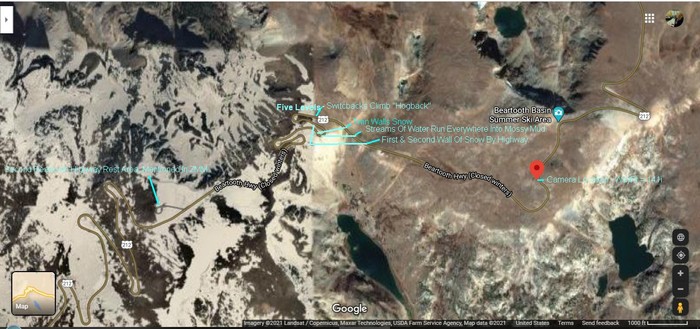
A Satellite View Of Central Beartooth Plateau, MT-WY Border Region=>
. Showing At Upper Center The Beartooth Highway. US-212, =>
..A) You Can See Green Labels =>
1) Five Levels of Switchbacks Climbing a Hogback.
2) Narrators Twin Walls Of Snow => Look Real Close To See Highway US-212 There AND REMEMBER, B/c This Exact Place is Several Times Featured is Forth Coming Photos.
3) Four More Green labels, Worthy Of Your Close Attention.
..B) Lower Center & Lower Right, The Very Dark Areas Are Respectively Gardner Lake & Christmas Lake.
..C) Above Words Beartooth Basin, The Dark Roundish Area Is An Unnamed Lake, Upstream From (unseen) Twin Lakes =>
NOTE: These Twin Lakes Are Significant Because They a) Are A Quite Noticeable Land-Mark In Photos & Satellite, AND b) Mark The Lower End Of Ski Lifts, Which Are In Turn A Great Summer Skiing Area. The Top Of These Ski Lifts Are Accessed Along A Snowy Stretch of The Beartooth Highway, and The Subject of Forthcoming Photos..
..D) In The /\ Above /\ Satellite View => Practically Every Patch of White (Big Or Small) Is Snow.
..E) In The Lower Left Of Photo Are Some of The Largest & Whiter Patches Showing Large Banks Of Evident Deep Snow!
..F) Cont: Especially Note The Super SOLID WHITE, HUGE & DEEP SNOW, Just SE of. The Hogback
..G) As Stated In Previous Aerial Photo, AND You Can See In NEXT Toto Map =>
..H) This Geographic Hogback Formation Is Practically The ONLY Connecting Land-Bridge, Between Two Otherwise Separated Major High Altitude Beartooth Plateau Areas.
..I) Here A Unique Combination Of Geological & Geographic Mountain Features Propel This Hogback Formation, To Become Significant To The ZMM Narrator, In His Writing Twin Walls Of Snow => Next Down. =>
[
.Soon we are between banks of old snow, the way snow looks in early spring after a thaw. ]
. Little streams of water run everywhere into mossy mud, and then below this into week-old grass and then small wildflowers, the tiny pink and blue and yellow and white ones which seem to pop out, sun-brilliant, from black shadows. Everywhere its like this! Little pins of colored light shoot forth to me from a background of somber dark green and black. Dark sky now and cold. Except where the sun hits. On the sun side my arm and leg and jacket are hot, but the dark side, in deep shadows now, is very cold.
.
. The snowfields become heavy and show steep banks where snowplows have been. The banks become four feet high, then six feet, then twelve feet high. We move through twin walls, almost a tunnel of snow. Then the tunnel opens onto dark sky again and when we emerge we see were at. [The start of The Hogback and soon will be at ] the summit.
.Beyond is another country. Mountain lakes and pines and snowfields are below. Above and beyond them as far as we can see are farther mountain ranges covered with snow. The high country.
Beartooth Highway, ~2 Miles Straight South of Montana-Wyoming Border, In The Center Beartooth Plateau, Near MT-WY Border. The /\ Above /\ Satellite View shows the central region of the Beartooth Plateau: This View also includes The Ski Lift Area Along The Beartooth Highway.
.As you read the Interlude below, the /\ Above /\ Satellite View Will Help You Understand 1) The dynamics of just what causes these Super Deep Walls Of Snow: And 2) Why these Walls Of Snow happen to be along the Steepest Edges of Rock Creek Canyon.
..****************..
A Continued Interlude & Explanation, Which Will Be Followed By NEXT PHOTO A Helpful Topo Map.
. As you read below (also Next Photo of a Topographical Map), please make mental note of the Various Named Places AND Their Physical Locations. This will help you as you read the Next ~28 Forthcoming Photos. .
..Why Is Left Half Of The /\ Above /\ Satellite View Dramatically White With Snow? ((Which Is Typically NOT True Of Most Of The High Altitude Beartooth Plateau.))
.. Here it will be important for you Dear Reader to keep in mind this B) below, which was already mentioned as B) in Previous Photo =>.
..B) Due to the sharp & very steep slopes on both sides of this Hogback ((As was seen Previous Photo Lower Right, where you saw how VERY steep is the slope on this side of this Hogback )), this steep slope & sharp top edge, act on Snow carrying Eastward Flowing Winter Winds coming along connecting valleys ((off screen to left of /\ Above /\ Satellite View)) from the relatively close Rock Creek Valley, even further to left (West) => Here winter winds do an aerodynamic up-sweep + swirl action, that nicely drops deep layers of snow hereabouts, as is dramatically shown in the /\ Above /\ Satellite View Photo.
Similar geographic features happen at the Beartooth Highways Summer Ski Area, along the Beartooth Highway =>
..In /\ Above /\ Satellite View =>
.1) This Summer Ski Area is along US-212 just above where you see US-212 go off the photo edge, upper right. There is no Winter Ski Activity here, because the Beartooth Highway is closed in Winter.
.2) As was shown and mentioned in the previous Aerial Photo, to Lower Right is Gardner Lake, which as you see is in a Deep Valley In Shoshone National Forest..
SIDE NOTES:
A) In the /\ Above /\ Satellite View Lower Left => You see a roughly square area that => Has an extra whiteness.
.We can surmise that this is due to this portion, being photographed, at different conditions. These might be more Snowy Wintery Conditions, or Sun Illumination, etc.
B) For any of these Forthcoming Photos => You may need to click several times on the photo, to get the largest and best view.
C) To Do Your OWN Study Of The /\ Above /\ Shown Satellite Map, Click Here.
************************************
(Photo = GoogSat SwBksHogbackBeartooothHy+RedPinHsgWayPr141i+Snow+WherZmmPix2.jpg..... ZMM Page = 110 ...... WayPt = 144w)