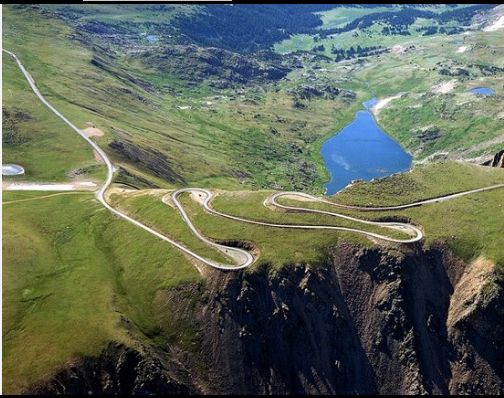
In The Center Of The Beartooth Plateau, We See => A Dramatic Aerial View Of The Beartooth Highway Climbing a Hogback!
.This Hogback, As A Geographic & Geological Formation => Is Practically The ONLY Connecting Land-Bridge, Between Two Otherwise Separated Major Hi Altitude Beartooth Plateau Areas.
.Beyond The Hogback, You See Gardner Lake and A Deep Valley In Shoshone National Forest.
.Here, A Unique Combination Of Geological & Geographic Mountain Features Propel This Hogback Area To Become Significant To The ZMM Narrator.
.. The road turns inward, away from the gorge and into snowfields.
The engine backfires fiercely from lack of oxygen and threatens to stop but never does. Soon we are between banks of old snow, the way snow looks in early spring after a thaw.
.To See A Dramatic Example of The ZMM Narrators ..between banks of old snow => RIGHT CLICK AND SELECT NEW TAB
Beartooth Highway, ~2 Miles Straight South of Montana-Wyoming Border, Central Beartooth Plateau, MT-WY Border Area. This Dramatic Aerial View
Serves To Start The Following Discussion Of just how Super Deep Walls Of Snow Comes To Be Here, and Earlier Along The Beartooth Highway.
DATE-LINE: April 2, 2021. by Henry Gurr.
TO ORIENT THE READER TO NEXT 21 PHOTOS, CONCERNING WINTER SNOW DEPOSITS. =>
.
Here STARTS => An Interlude & Explanation, Which Will Then Be Followed By Forthcoming 1) A Helpful Satellite Photo View, and Then 2) A Helpful Topo Map.
..****************..
..A) The Land-Bridge Formation, shown in /\ Above /\ Photo, is very important for the Beartooth Plateau, in that it is the ONLY practical way for Humans (whether hunters, prospectors, build highways, or other travel) to move North-South, between Two Otherwise Deep Canyon Separated Major High Altitude Land Surfaces. This Will be fully illustrated in the SECOND Next Photo of a Topographical Map.
..B) Moreover => The sharp & very steep slopes, on both sides of this Hogback, Act Upon Overflowing Eastward Winter Winds coming along connecting valleys, from the relatively close Rock Creek Valley => Here do an aerodynamic up-sweep + swirl action, that nicely drops deep layers of snow hereabouts => One such dramatic, area of really deep snow, is shown in the Next Satellite View Photo.
(Similar geographic features happen at the Beartooth Highways Summer Ski Area NW of here.)
..C) In the /\ Above /\ Photo, you see none of this snow: And as is true for my (Henry Gurr, Sept 2006) Photos, depending on season, & how steep is local landscape shielding from the sun, all the snow can be still there in some places, and in other places, be all melted away. This is with no remaining evidence of any snow having been there, as is the case in /\ Above /\ Photo.
.. D) By opposite contrast, the ZMM Narrator in Early July 1968, & Henry Gurr in June 2002, readily found Walls Of Snow along US-212 Beartooth Highway. Thus we can see that deep snow can be there up through early July, but be all gone by September.
..E) As you read 1) This Photo Caption, and 2) the Next Satellite View Photo Caption. and 3) The SECOND Next Photo of a Topographical Map => Please make mental note of the Various Named Places AND Their Physical Locations. This will help you as you read the Forthcoming Photos. .
..F) Here I must say => From both of my 2002 AND 2006 ZMM Route Research Trips through this Beartooth Plateau, I understood NONE of A) & B) above relationships!
It was from CLOSE study of the above mentioned Satellite Views, combined with CLOSE study of the above mentioned Topo Maps, did I even begin to start to Tease Out, the above A) & B) discussion and understanding.
..G) In fact, it was ONLY the ~Accidental Discovery of The /\ Above /\ Hogback Aerial Photo by Merv Coleman, which AHA, spurred me to start me studying all of this closely!!
AND of course all this entirely new understanding is now edit modified, into this Caption AND the Captions Of Forthcoming Next Photos.
..H) For any of these Forthcoming Photos => You may need to click several times on the photo, to get the largest and best view.
PHOTO CREDIT: By Merv Coleman (YellowstoneCountry, Aug 2017)
....Coleman Photography, 223 Broadway Ave S #1249, Red Lodge, MT 59068 Phone: (800) 726-2228 << NO work. Goog finds 406) 446-1228 << which works.
....
The /\ Above /\ Photo Is Courtesy Of Tripadvisor
*************************
(Photo = www.tripadvisor.ca-#276854502%beartooth-highway-photo{MervColemanAug2017.jpg ...... ZMM Page = 110 ...... WayPt = 144w)