.As You Read The Below, Please Make Mental Note Of The Various Named Places AND Their Physical Locations. This Will Help You As You Read The Forthcoming Photos.
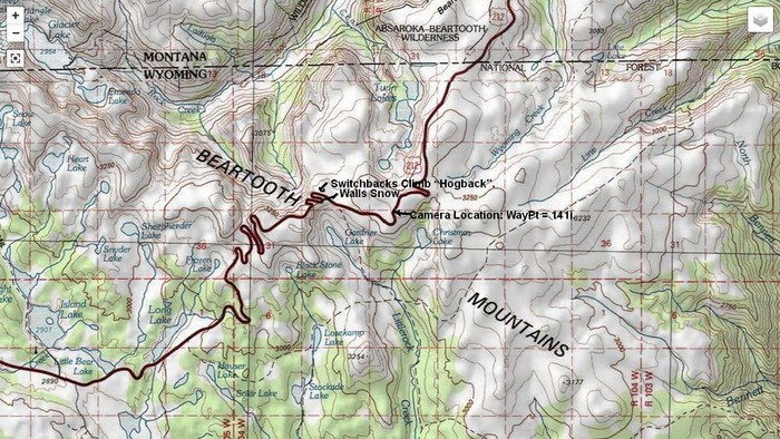
A Topographic Map Of The Beartooth Plateau Showing Just Left of Center =>
..A) The Beartooth Highway, US-212, Climbing a Hogback.
..B) At Center Also Note =>The Black Bold Labels => 1) Switchbacks Climb Hogback , 2) Walls Of Snow, and 3) Camera Location of WayPt = 141i.
..C) Below Center Note Two Light Blue => Gardner Lake & Christmas Lake.
..D) Above Center Note Light Blue => The Roundish Area Above Word Switchbacks => This Is An Unnamed Lake, Upstream From Where You see Twin Lakes => The Unnamed Lake and The Twin Lakes Are Significant, Because They Mark The Lower End Of Ski Lifts, Which Are In Turn => Great Summer Skiing Down From A Close By Snowy Stretch of The Beartooth Highway, Which You Also See. These Are Subject of (And Shown In), Forthcoming Photos.
..E) To The Right of The Twin Lakes, You See Wyoming Creek, Subject of Many Previous Photos.
..F) In The /\ Above /\ Topo Map => The Relatively Uncluttered Whitish Areas Are Mountain Peaks of the Central Beartooth Plateau.
..G) As Stated Previous Photo, AND As You Can See In /\ Above /\ Toto Map =>
1) From The Top of The Above Topo, To Its Bottom => You Can Follow US-212 South, And In So Doing => You Will See The Marked Hogback Formation Is
2) Practically The ONLY Non-Deep-Valley Geographic Connecting Land-Bridge, For A Highway To Go South, And Then West, To Yellowstone National Park.
..H) AND Remember => Because This Hogback Is Narrow & Quite Steep, It Creates A Wind Action, That Hereabouts Deposits Deep Snow! Most Especially SE of This Above-Mentioned Hogback.
I) Thus => This Is Where => A Unique Combination Of Geological & Geographic Mountain Features Propel This Area To Become Significant To The ZMM Narrator.
..**********************..
. The snowfields become heavy and show steep banks where snowplows have been. The banks become four feet high, then six feet, then twelve feet high. We move through twin walls, almost a tunnel of snow. Then the tunnel opens onto dark sky again and when we emerge we see were at. [The start of The Hogback and soon will be at ] the summit.
.Beyond is another country. Mountain lakes and pines and snowfields are below. Above and beyond them as far as we can see are farther mountain ranges covered with snow. The high country.
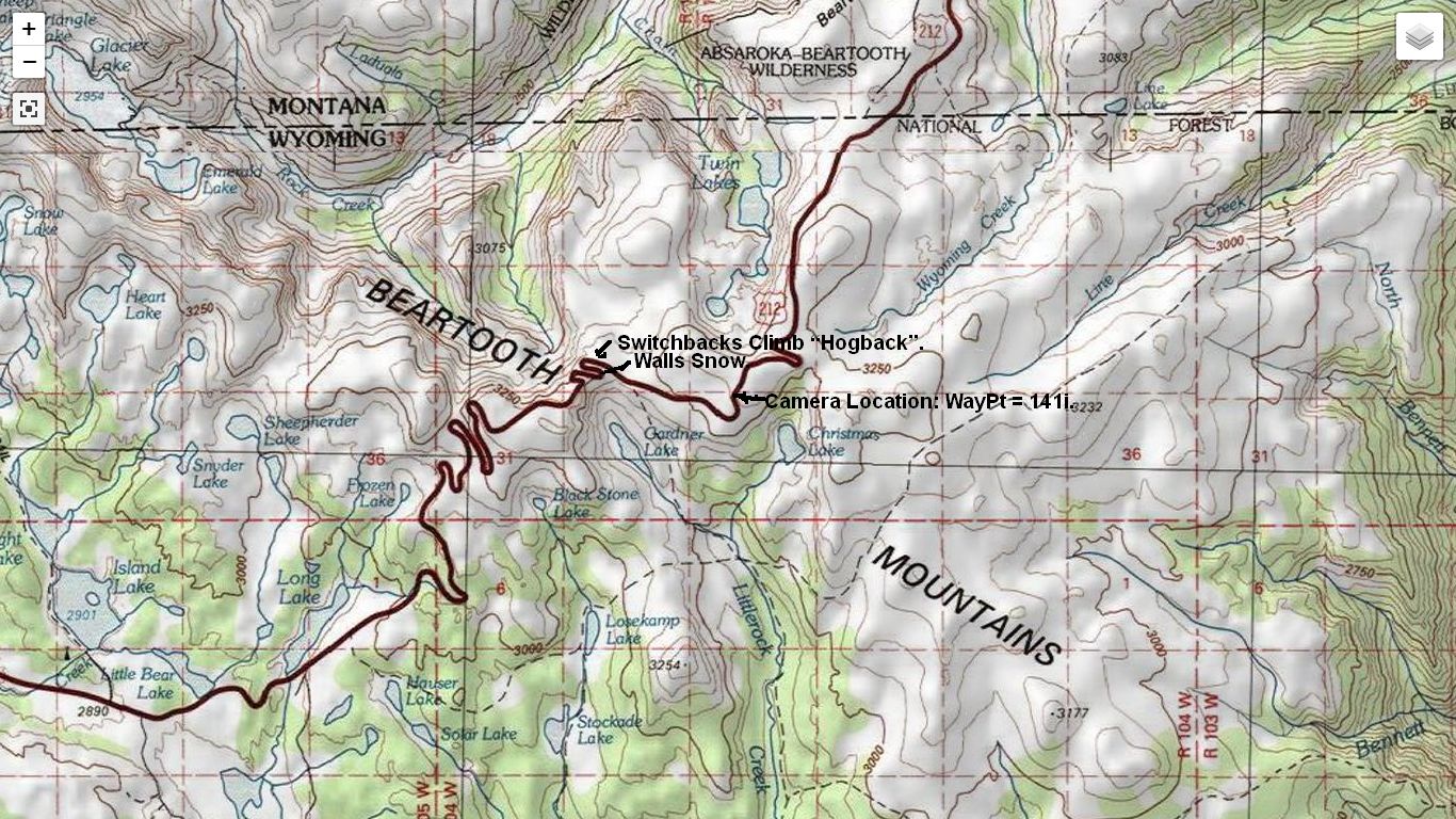
Beartooth Highway, In The Center Of Beartooth Plateau, MN-WY Border Region. This /\ Above /\ Topographic Map View, Serves To Illustrate and Finish This Discussion Of => A) Just how Super Deep Walls Of Snow Just Happen To Be HERE. B) And show these in the /\ Above /\ Map View, and as well C) At The Ski Lift Along The Beartooth Highway.
To Finish This Interlude Explanation, The Following REPEATS Previous Photos =>
.Here it is sufficient for you, Dear Reader, to keep in mind, as already mentioned in Previous Photos =>.
..B) Due The sharp & very steep slopes on both sides of this Hogback, Eastward Flowing, Winter Winds coming Eastward along connecting valleys, from the relatively close Rock Creek Valley => Here do an aerodynamic up-sweep + swirl action, that nicely drops deep layers of snow hereabouts, as was dramatically shown in the Previous Satellite View Photo.
Similar geographic features happen at the Beartooth Highways Summer Ski Area, which are up the steep slope, East of the Twin Lakes, which is seen in /\ Above /\ Topo Map, at the twin blue areas, above Word Camera,.
..E) As you read the above, please make mental note of the Various Named Places AND Their Physical Locations. This will help you as you read the Forthcoming Photos. .
..F) For any of these Forthcoming Photos => You may need to click several times on the photo, to get the largest and best view.
..************..
To Do Your OWN Study Of The /\ Above /\ Shown Topographic Map, Click Here.
************************************
(Photo = TopoZnFulScrnBeartoothHy&Mts Diag}GlacierLake-Bennett ForShoAlbmZmmPt2 Wher2.jpg
...... ZMM Page = 110 ...... WayPt = 144wt)