A Scenic View Showing the Five Switchback Road =>
.Which Climbs The Steep Hogback Land-Bridge Formation =>.
And Shows Where the Narrator Found The Twin Walls of Snow".
.[ The snowfields become heavy and show steep banks where snowplows have been. The banks become four feet high, then six feet, then twelve feet high. We move through twin walls, almost a tunnel of snow. ] Then the tunnel opens onto dark sky again and when we emerge we see were at the summit.
.Beyond is another country. Mountain lakes and pines and snowfields are below. Above and beyond them as far as we can see are farther mountain ranges covered with snow. The high country.
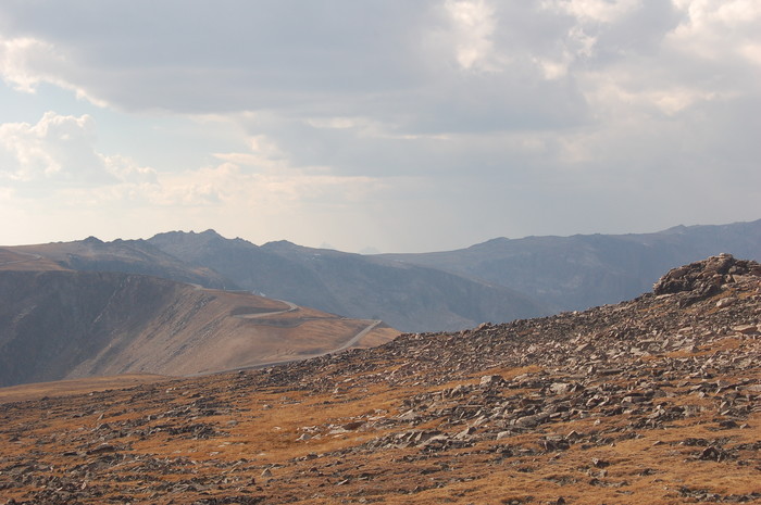
AFTER The Distant Horizon Ridge Is The ZMM Narrators High Country, Beartooth Highway, WY..In /\ Above /\ Photo Center Screen, , just over the rocks left center, you see the downward trending road ahead. This is the SAME stretch of road shown in the Previous Photo.
.The road then somewhat turns left, and then starts to climb up this somewhat narrow "hogback", and follows a series of 5 switchbacks, steadily climbing 6% grade, to finally go over (unseen) The ZMM Narrators at the summit
. Beyond is another country.
The high country.
..****************..
.Here Please Remember The Previous Interlude Discussion At =>
..The Dramatic Aerial View Photograph =>
A Dramatic Aerial View Of The Beartooth Highway Climbing a Hogback!
..****************..
.AND NOW => In the /\ Above /\ Photo, with your Memory of The Previous => Dramatic Aerial View Photograph => You should delight to discern this well remembered Hogback Land-Bridge Formation, but of course seen from a vantage point about a mile away and from quite a different angle.
.On this Land-Bridge is exactly the location of the Narrators The snowfields become heavy and show steep banks where snowplows have been. The banks become four feet high, then six feet, then twelve feet high. We move through twin walls, almost a tunnel of snow. Then the tunnel opens onto dark sky again and when we emerge we see were at the summit. ".
To Help Prepare Your Eyes And Mind => To Really See What Is There!!
.Please Keep In Mind =>The Following Forthcoming Photo Sequence.
..A) A Magnified Telephoto View Of The /\ Above /\ Photo, taken from this same WayPt = 141 location.
..B) FIVE Forthcoming Photos showing six feet, then twelve feet high. " The snow in these 5 photos happens to be (as seen in /\ Above /\ Photo) up from the rocks the first tier, which is after the first switchback at left.
.AND then twin walls, almost a tunnel of snow. " is just after the second switchback a bit let of photo center seen /\ Above /\. => =>
.These 5 Photos Will Show The Narrator's ""Ever Deepening Snow
.THEN Twin Walls Of Snow . As Follows =>
..1) 100 feet prior to.
..2) 15 feet prior to.
..3) 15 feet prior to (close up).
..4) At the 2nd switchback.
..5) At the 2nd switchback (close up).
..****************..
DATE-LINE: April 10, 2021. by Henry Gurr.
As Has Been Discussed Previously At => Way, Way, Previous Interlude Dramatic Aerial View Photograph =>
..In Traveling This Road Twice (2002, 2006), I Did Not At All Know Any Of This Or Even Begin To Appreciate =>
..A) The dramatic nature of how this road crosses over that narrow, steeply inclined, Land-Bridge called in this album Hogback or alternate name "Razorback".
..B) The fact it's the only way to transfer between two broader highland plateaus, and thus
..C) This Land-Bridge makes it FAR EASIER, AND MAKES POSSIBLE to construct the Beartooth Highway, from Red Lodge, MT to Yellowstone National Park.
..D) Here A Unique Combination Of Geological & Geographic Mountain Features Propel This Hogback Land Bridge, To Become Significant (Very Deep Show) To The ZMM Narrator.
..E) It was ONLY from CLOSE study of Previous Interlude => a) Aerial Photo, b) Satellite View, and c) Topographical Map => Combined with CLOSE study of previously shown Interlude Topo Maps, ONLY THEN did I (Henry Gurr) even begin to start to Tease Out the above A), B), C), D), & E) discussion and understanding.
..F) In fact, it was the ~Accidental Discovery of the previously shown Interlude Dramatic Aerial View Photograph by Merv Coleman, which, AHA, spurred me to study all of this closely!!
..G) AND of course all this new understanding is now edit modified into the Previous and Forthcoming Photos & Captions.
CONCLUSION:
.If you plan to travel this way, study this photo to prepare your eyes and mind to really see what is here!! Ditto for continued viewing in this Photo Album!
*************************
(Photo = September 2006 0075 ...... ZMM Page = 110 ...... WayPt = 141m 10,836ft)