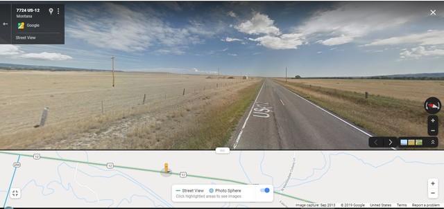
~9:50 am Mon 12 Aug: Wheatland County, MT, Typical View Over Desolate Dry-Lands From US 12, ~1 Mile East Of Junction Of US 12, With Rt 294.
. As stated in previous Photo, at Townsend, MT, Henry Gurr turned East onto US 12, where travel climbed out of the Valley of The Missouri River. The pleasant views of US 12 along the steady climb, close by Deep Creek, gradually changed to the forested slopes, pleasant views, & swings of US 12 through The Big Belt Mountains.
.After this memorable experience, the road landscape changed to, equally memorable, 60 miles of desolate, irregular-semi-level, dry-lands, which is shown in /\ ABOVE /\ Google Street View (GSV) Photo. Also in the /\ ABOVE /\. GSV Strip Map, you may see the US 12 Highway Location this GSV, relative to Junction with Rt 294. This is the subject of the Next Photo.
.This Google Street View (Same As Photo /\ ABOVE /\.), Offers A 360 deg Full Circle Panorama, Looking Over This Vast Isolated Desolate Terrane, and a Typical Example of Travel Scenery For The Last 60 Miles. .
.Neither of these (above discussed) contrasting landscape realities prompted Henry to realize => Stop & Take A Photo. >> This Is The Reason You Are Looking At A Google Street View (GSV) /\ ABOVE /\.
Cont Next.Photo => A PANORAMA VIEW Of => A Beautiful Green Valley With Scenic Mountains Beyond.
Photo File = GoogStVu WheatlandCoMT}OnUS12AtJunct294 DesolateVastFlad&DryLand.jpg
Posted 12 July 2020, Revised 14 Oct & 5 Nov & `12 Nov 2020.