A Close-Up Satellite View & Notes Concerning The Geology & Geography of ~30 Miles of Central Montana, That Also Shows Small Part Henry Gurr Route Of Travel On US 12.
.NOTE: As you read the below, you may wish to consult the => Satellite View of Central Montana mentioned SECOND Previous Photo.
..A) This might still be Up as a separate Browser Tab. OR
..B) You could go back to this, and thus
And Click On Its Link
By => Upper Left of your Browser, TWICE Click on the LEFT Back Arrow. ((You should remember this, For Future Browser Efficient Usage!!)
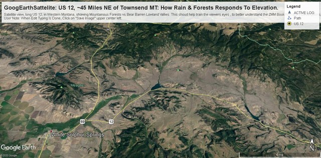
.. The /\ Above /\ Close-Up Satellite View To help you Understand How US 12 Fits-Into Other Montana Roads: Please be aware that US 12 from Previously mentioned => Townsend, MT( at the Missouri River), is ` 50 miles Southwest, off-of the Lower Right of the /\ Above /\ View Shown.
.GENERAL INTRODUCTION TO /\ ABOVE /\ SATELLITE VIEW: >
.To Help Train Your Viewers Eyes, AND To Better Understand The ZMM Book Narrator's Descriptions. Please Carefully Study The Following = :-))
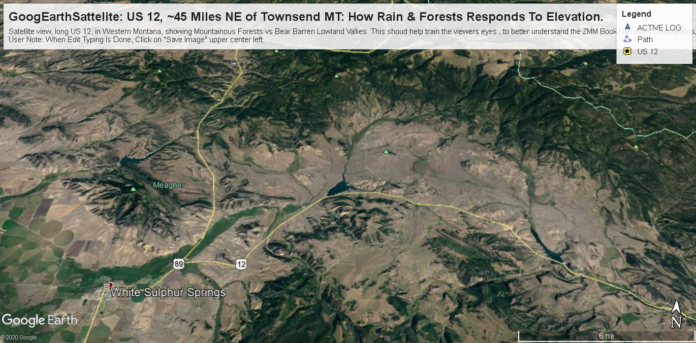
Please Scan Around This /\ Above /\ Satellite View, AND Notice =>
.Straight East from Townsend, MT, US 12 goes over a darker green Range of Mountains (discussed & shown previous photo, but not shown /\ above /\.), called The Big Belt Mountain Range), then joining with US 89 goes north to White Sulphur Springs, MT. As seen in this Satellite View, both routes follow the edge of a green valley Northeast for ~5 miles, whereupon US 12 splits off to go generally East in semi-arid valleys, between Mountain Ranges.
.It Is An Observed Fact That Higher Elevations Are Cooler, And White Areas In Photo Like The Above Are Snow, Which Tells Us Where The Highest Peaks & Ridges Are.
.Generally An Increase In Elevation Is Enough For Extra Rain, Thus Creating Forested Meadows,
.Which the ZMM Narrator Delightfully Reports in ZMM Chapter 7.
.In above Satellite View, the higher elevations are the forested darker green areas, and reliably can be used to discern areas of higher relative landscape elevation:
.Another Useful Way To Discern Relative Elevation, Especially Down-Hill At A Particular Location, Are the lines of darker trees showing rain water run-off channels: In the above Satellite View, these typically surround the larger forested dark green mountainous areas, and a characteristic of interest in this Satellite View. These streams provide irrigation water for agriculture areas, which show in this satellite view, as Lighter Colored Patchy Areas, some of which are circular or rectangular, and showing presence of human activity!
.Many Places You See These Darker Green Tree Lines That Come Together, And Become Larger. If you follow these, they eventually become large enough to have sandy bottom, twisty-curvy, dry stream channels. If you pay attention to these, you can use these to identify the general downward slope of the surrounding land. Not as good as a Topographic Map, but good enough for lots of purposes!
.We Hope You, Will Take Some Time Studying These Darker Green Tree Lines, where you can imagine run-off rain waters would flow in streams and gulches: This will train your eyes to Really See, in Google Earth Images later in this Gallery Album. :-))
Your Close Study of /\ ABOVE /\ Special Geography Note
. Will Help Train Your Viewers Eyes", To Better Understand The ZMM Book Narrator's Descriptions, As Relates Forthcoming Phots In This Album. :-))
Cont Next.Photo:
Photo File = GoogEarthSattelite US12 FmWhiteSulpherSpringsMT ToCheckerboardMT .jpg
Posted 28 Apr 2020, Revised 12 July & 5 Nov & 16 Nov 2020.