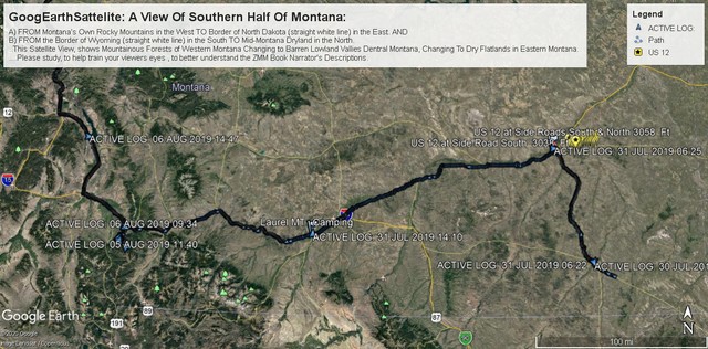
Continued From Previous Photo => A Satellite View & Notes Concerning The Geology & Geography of Southern Montana, That Also Shows Part of Henry Gurrs Route Of Travel.
...THIS GOOGLE EARTH SATELLITE VIEW, SHOWS MOUNTAINOUS FORESTS OF WESTERN MONTANA, CHANGING TO BARREN LOWLAND VALLEYS OF CENTRAL MONTANA, CHANGING TO DRY FLATLANDS IN EASTERN MONTANA:
A) SEEN /\ ABOVE /\ => In the West=> FROM Montanas Own Rocky Mountains
TO the Eastern Border of North Dakota (see straight white line). AND
B) SEEN /\ ABOVE /\ => In the South
FROM the Border of Wyoming (see straight white line)
TO In the North Mid-Montana Dryland.
.GENERAL INTRODUCTION TO /\ ABOVE /\ SATELLITE VIEW: >
.To Help Train Your Viewers Eyes, AND To Better Understand The ZMM Book Narrator's Descriptions. Please Carefully Study The Following = :-)) :-))
Please Scan Around This /\ Above /\ Satellite View, AND Notice =>
..1) Small green triangles, marking highest mountain peaks, some are white with snow!
..2) Larger green triangles, marking National Forests, these are Dark Green with trees.
..3) Thin Lines (Yellow, White, Red-Blue): These are roads where some are labeled
with Icons, such as US 14, I-90.
..a) See US 12 Icon Upper Left, which goes East to join BlackLine,
marking un-labeled Helena MT.
..b) See upper most on Satellite View, East trending, the un-labeled ThinYellowLine,
..is US 12. This is seen to turn SE, & join BlackLine, marking un-labeled Forsyth MT.
..c) Yellow Google MapPinPoint Upper Right at ThinYellowLine = US 12, from
.. Miles City, MT, East to un-labeled Powder River, at Right Edge of Satellite View.
..d) At above image LEFT Edge
i) A ThinYellowLine going west, is I-90 as indicated by Icon.
.ii) And above I-90 Icon, trending NE is I-15, to Helena, MT: Helena, MT, is also
.marked by a ThinYellowLine from US 12 icon, at upper left image edge.
..4) Henry Gurrs GPS Data, Imported Into His Computers Google Earth APP, Gave What You See In /\ Above /\ Satellite View => .
..a) TinyBlueDots, marking Henrys GPS way-points, along BlackLine.
..b) LargerBlueTriangles, marking Henrys GPS Location, when started a new day.
..c) BlackLine, Marking Henry Gurrs July & August 2019 Travel,
i) FROM => Bayes, MT (See /\ Above /\, at lower right along US 212, in SE MT.
.... ii) TO => Miles City, MT to > I-94 West, to> which joins I-90 at Billings, MT.
.iii) THEN => I-90 West to Three Forks, MT to> There turn North of on US 287 &
..cont on US 89 into NW Montana, and eventually Glacier National Park (GNP).
You May Read => A MUCH MORE COMPLETE EXPLANATION Of
.A) ABOVE Google Earth Satellite View Southern Half Montana, AND
.B) A More Complete Illustration Of Henry Gurrs Additional ZMM Route Research July-Aug 2019: '''
Right Click Here &, Select New Tab, For An Explanation Of Important Features That Can Be Seen In Henry Gurrs ''Google Earth Satellite Image of Southern Montana.'' Many of these features relate to The Montana portion of US 12 = ZMM Route East. :-))
Cont Next.Photo => A Close-Up Satellite View & Notes Concerning The Geology & Geography of ~30 Miles of Central Montana, That Also Shows Part Henry Gurr Route Of Travel On US 12:
Photo File = AGoogEarthSattelite SouthernHalfMontana .jpg
Posted 28 Apr 2020, Revise 11 July & 4 Nov 2020.