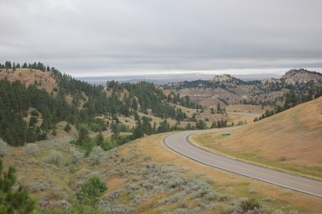
Continued fm Previous Photo => Looking To The West Over The Yellowstone River Valley => The ZMM Narrators Promised Land.
.8:02 am Tues 13 Aug: A Telescope View (From Henry Gurrs Climb To), Top of South Bluff, of US 12, Near Top of the Mountain Pass, 10 Miles East of Miles City, MT.
.The ZMM Narrator, Looking To The West Over The Yellowstone River Valley, and, Seeing A View, Such As Photo Shown /\ Above /\, Continues With This Climatic Ending His Chapter 7, (and Ending ZMM Part I ), With This Sentence =>
I AM A PIONEER NOW, LOOKING ONTO A PROMISED LAND.
.Photo Note => How To Correctly Discern The ZMM Narrators Description =>
.. under pines through which I can see the far side of the valley, away and below. =>
This Valley is seen in /\ Above /\ View, BUT you must know that the Valley itself, is at a much greater distance beyond any of what you see as distant tree covered dry grass brown colored slopes:
.To discern the ZMM Narrators => far side of the valley, away and below. , you should identify the lighter band of sky below the horizons grey clouds, and below that, then discern the line of landscape horizon, and below that, the far river valley side slopes, which are a fuzzy grey, with a tiny touch of brown.
There is one more interesting part of this valley, despite its very difficult to see in this photo, :=> Looking very close (with magnifying glass, OR hold down CTRL Key & press + Key several times.), and looking, just a bit left of center, and ~1/4 inch below the landscape horizon, there is a darker ~1 inch wide somewhat darker lump. On Satellite Photos or Topo maps, this is a rather large mound approximately centered, in this valley. The river once upon a time, apparently flowed on both sides of this mid-valley mound. Miles City, MT, is to the left of this mound, and thus up-river. Down river is to the right, where the river trending NE, eventually joins with the Missouri River at the Montana North Dakota Border.
.Also interesting In /\ Above /\ Photo => Many places above the Green 10 Mile Sign, you can just make out horizontal multi-colored layers of volcanic dust, & mountain rock . ((NOTE: This Topic Was Mentioned In This Albums 12th & 13th photos))
.To Learn More About This Volcanic Layers Topic, You May Wish To Go To =>
.This Special Explanation Page, (with many links), Discusses Montanas Ubiquitous Multi-Colored Layers Of Volcanic Dust & Mountain Rock, Giving Evidence Of Very Long History Of Eruptions, Through Eons Of Time. Most Of These Are From Yellowstone National Park, Massive Volcanic Eruptions, OVER 335 MILES to the Southwest, From Miles City, MT !!
.Click Here & AFTER This Page Comes Up => Then Scroll Down To PART THREE:
Cont Next.Photo => Local History Sign, At Powder River Park & Road-Side Rest Areal:
Photo File = DSC_0559
Posted 18 Oct 2020. Revised 11 Oct & 18 Oct.