Added July, 2004
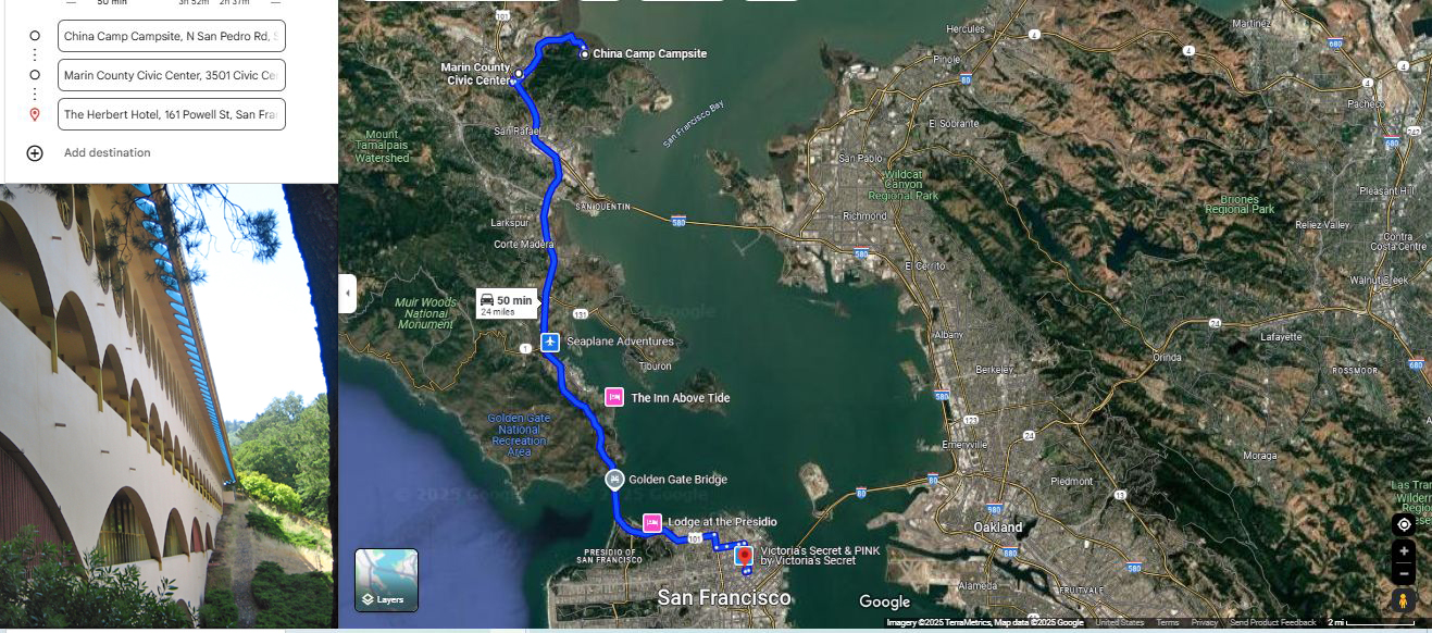
A Google Satellite View Shows David Matos & Henry Gurrs Travel Route => FROM Their Campground, At China Camp State Park, Near Shore Of San Pablo Bay, Near San Rafiel, CA, THRU Marin County Civic Center, San Rafael, CA, Along US-101 Over Golden Gate Bridge TO Herbert Hotel, Downtown San Francisco CA.
China Camp State Park, Is Within One Hour Drive (22 miles) Of San Francisco, CA.
At Left Is Result Of Add A Destination Feature Of Google Maps. This Allows Addition Of As Many Waypoints As Wanted!! And Then Automatically, The Route Is Shown In Blue!!!! Along With Places So Designated !!!!!!
At Left Is List, Supplied By The User, To Easily and Nicely Create This Travel Route Onto This Google Satellite View.
********************
You May Bring Up The ABOVE/\ Satellite View, And Conduct Your OWN ClickDrag Exploration (Plus Zoom In For More Detail). Click Here.
********************
For A Satellite View Of The Location Of China Camp State Park, Which Has The Camp Ground, Where We Stayed Overnight, And The Roads To Get There: You May Bring Up A Satellite View, And Conduct Your OWN ClickDrag Exploration (Plus Zoom In For More Detail). Click Here.
********************
********************
You May Bring Up A Google Street View Of What David Matos & Henry Gurr Saw, When They Arrived In The Parking Lot, At Their China Camp State Park, Campground, Showing, In The Distance, The Valley Having The Camp Sites. Click Here.
NOTE: This is the valley, that has the walkway that we followed to our campsite and some 20 other Campsites.
********************
You May Bring Up A Google Street View Of The Scenery At China Camp State Park, Showing, The Valley Which Has The Park Rangers Buildings and Campground, Camp Sites. The buildings are shown in white, East of the Orange Pegman, in the bottom strip map. Click Here.
NOTE: This is the valley, that has the walkway that we followed to our campsite and some 20 other Campsites. This Valley Also Has The Park Rangers Buildings and Campground, Camp Sites. The buildings are shown in white, East of the Orange Pegman, in the bottom strip map.
********************
Wikipedia Gives Details About California State Park Campground, called China Camp, AND Explains The History Of The Early Chinese Fishing Village On San Pablo Bay. Click Here.
In /\Above/\ Photo, At Lower Left Is => A View Of The Marin County Civic Center, Designed By World Famous Architect, Frank Lloyd Wright, located along U.S. Highway 101 near Santa Venetia. CA,
NOTE: Many Great Photo Views Of This Marin County Civic Center: AFTER Comes Up, Read 5th Small Photo (Satellite View To See Location) THEN Read 6th Small Photo (Starts 12 Photos Of Civic Center). Click Here.
********************
EXPLANATION:
Ever Since July 8, 2024, David Matos & Henry Gurr,Have Been Following The ZMM Route From Minneapolis, MN, And Their Experiences Have Been Added To The ZMM Book Four Photo Gallery Albums, Accessible, Click Here.
The Photos Of THIS Album Show Their Experiences => In San Francisco, CA, And Then On Their Way Home To Aiken SC.
They Visit Stuters Fort In Sacramento, CA, Non-Stop Thru Las Vegas & Lake Mead. Photo Time At Bolder Dam ( ), Plus The REALLY Grand Canyon. & Brief Stop At Meteor Crater:
AND, The Photos Of This Album => .Start With, Wednesday, July 24, 2024, Showing David Matos & Henry Gurr Driving South On US-101, We See Our First Fog, Before Descending to The San Francisco Bay.
File = ScrnCapt GoogSaVu ChinaCamp MarinCountyCivic GoldGateBdg HerbertHoSanFranCA2 (1)
