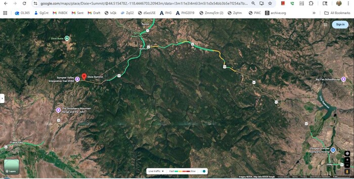
A Satellite View Showing The ZMM Route Ahead, Along Which You Will See Photos Forthcoming.
IN THE /\ABOVE/\ SATELLITE VIEW YOU CAN SEE =>
A) US-26 Highway, 50 Miles, FROM Unity, Oregon, Lower Right, TO Prairie City, Oregon, Lower Left.
B) At Left, Along US-26 Highway, Is Seen 1) Sumpter Valley Interpretive Trail #260, And 2) At Red PinPoint, Dixie Sumit. And Then, At Right: Unity Reservoir
C) Brown Areas Are Arid Semidesert Land Of Dry Grass, Which Are At Lower Elevations, With Less Rain.
D) Light Green Areas, Are River Valleys, Some Of Which Show Irrigation.
E) Darker Green is Mountain Forest, At Higher Elevation With More Rain.
F) At Center, The Large Dominating Area Of Darker Green is Mountainous Malheur National Forest, Which As You Can See, US-26 Highway Partly Avoids By Curving Around To The North.
G) To The Upper Right Of Word Dixie Summit, You See A Long Straight Line, Which Can Be Followed To Upper Right Off Screen, And Also, Followed To Lower Left For Several Inches. This Is Likely A Present-Day Railroad Track.
H) Below The Red PinPoint, Along US-26 Highway, You Can See Words => The Strawberry Mountain Range and the John
..
. This range (See NOTE1: Below), is a rugged, 9,000-foot-plus Mountain Range in Oregon's Malheur National Forest, often known for the Strawberry Mountain Wilderness. This includes diverse eco-zones and alpine lakes. Located east of John Day, Oregon, the range is part of the Blue Mountains, offering popular hiking, backpacking, and habitats for elk, deer, and bear.
NOTE1: At Blue Link NEXT Below => On The Terraine Map That Comes Up, You Should See The Following, Left To Right.
A) Strawberry Mountain Wilderness, but unfortunately, can not tell where all of that is
B) Strawberry Mountain: This Is the location of the peak, which you can see in the Google Earth View, SECOND Blue Link next down.
C) Strawberry Range, at Red PinPoint. We can assume that the Strawberry Mountain Range, includes all of the light tan higher elevations FROM Strawberry Mountain Peak ALL THE WAY TO the Red PinPoint.
D) Lookout Mountain, which you also will see in the Google Earth View, SECOND Blue Link next down.:
To See The /\Above/\ Satellite View, Click Here. ATTENTION: Of course you can ClickDrag to explore this map on your own.
NOTE2: At Blue Link Below => You Should See Strawberry Mountain, And Possibly Pick Out, Strawberry Mountain Range.
AFTER This Google Earth comes up, the peak of Strawberry Mountain, should be at center, and has 3 distinctive patches of snow. Click Here. ATTENTION: Of course you can ClickDrag to explore this map on your own.
NOTE3: AFTER The NEXT Above Blue Link Has Come Up =>
,,,In a.Google Earth, you will be looking at =>You can try to discern where all The Strawberry Mountain Range, is located.
This Range likely runs from the view in foreground, then up and over the Peak Of Strawberry Mountain, and then continues 3 inches to the right, and then left turn, curl around, part way toward Lookout Mountain.
File = SaVu US26FmUnityOR}PrairieCityOR DixiePass SumpterValyIntepretTrail UnityResvr