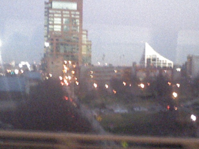
Weve Just Come Into An Area Where, In The Last Twilight, the Buildings On the Right (West) Are Too Close & Dark to get a useful photo: Looking East, the skyline is illuminated by the dying sun behind me. Catching my attention, is this Interesting Structure: Complimented By the White Swoop Triangular Roof at right, It's "Worth a Click".
Its 5:38 PM now, and we are out of the traffic jam ... getting dark & look'n around I'm seeing diminished Photo Op's. And besides Ive overworked the patience of my fellow bus riders, with a me leaning all over them to position my way too many noisy Centro Pix Clickxxs, having blasted out 46 loud Kerr-Klick-Whackkk!!
Thus, we say goodbye to Louisville KY:
******
Do you know the name of these two structures? If so ... Please send email. Ive studied the Google Satellite Photo (link prev photo), quite a bit and have struck out!!!
David Musser (more re him at end) emails the answer::
my friend Curt (founding director of Shakespeare Behind Bars, which is pretty cool) lived in Louisville for many years. So I asked him. His reply:
The taller of the two buildings is an apartment/condo building, and the triangular shaped building is an office building for an investment company called Blue Equity. The father Blue [is well known because he] owned a scrap metal business along the Ohio [River] that was purchased by the city so the riverfront could be developed back to nature.
Googling for The Blue Equity Building, I found the Google Map, link below, clicked on Satellite View, and indeed found the Triangle Roof Building, but was confused, as you see in my email back to David =>
Thanks for the info about the Apartment Building and Blue Equity Building!! Ill add this to the caption, with credits, of course!! Link below does indeed show a triangle roof, BUT Goog Map (link second below) shows Blue Equity to the West of I-65, and Im pretty sure my photo shows found the Triangle Roof Building, to the East: That is what I remember, plus look at the illumination of the sun and shadows, various places: Also says East. Thus Im very puzzled: Could you ask again, and if possible ask for Goog Map Link??
Again, many thanks.
Sincerely
. Henry
To which David answered: On the google map set at the Blue Equity Building at 333 E Main St. in Louisville you can see both the buildings in your photo. Looks to me like you are on I-64 west of Joes Crab Shack (on the map) looking southeast.
So
.. I looked again
. AND after exploring the Google Map, discovered The Clark Memorial Bridge, : a SECOND BRIDGE over the Ohio River!! It is quite similar to the I-65 bridge I assumed we were on, since I thought we were still on I-65. But exploring the Satellite View more, discovered the River Boats exactly were my photos showed them, hence I was on Rt 31 in Louisvelle, on our way to the Louisville Greyhound Bus Station. AND yes indeed, the Apartment Building and Blue Equity Building of my photo, are to the East of my location at 5:38 PM. NOW I suddenly remember, from here, we are almost at the Bus Station!! And despite all our time stopped in the traffic jam, we are essentially on time, since my bus ticket print-out, says we are due to arrive at the station at 5:35 PM !!
https://maps.google.com/maps?oe=utf-8&client=firefox-a&ie=UTF-8&q=contact+US+Blue+Equity,+LLC+333+East+Main+Street,+Suite+200+Louisville,+Kentucky+40202&fb=1&gl=us&hq=contact+US+Blue+Equity,+LLC&hnear=0x886972c7554bc645:0xca8872b6e04791b5,333+E+Main+St+%23200,+Louisville,+KY+40202&cid=0,0,2384362380579534723&ei=KxjpULGfDqnO0QHayYCIAQ&ved=0CIIBEPwSMAM
Compared To My Photo Above, You Can Get FAR BETTER **OH WOW** Views of the Apartment Building and Blue Equity Building, and the Waterfront Area of Louisville, By Typing In to Google 300 East Witherspoon Street, Louisville, KY 40202.
If you are lucky, you will be able to Click On Street View, at upper left, and then use you moues to rotate the view, magnify, de-magnify the view. You can even follow the arrows Street View shows on the pavement, to Drive along the same road, as did the camera vehicle that originally took these photos.
If the above does not work for you, click the link next below, and when the Google Map comes up, click on the A Icon at center, try clicking around and zooming in close Satellite View, and try to click around till you can click on blue words => Street View.
https://maps.google.com/maps?hl=en&q=north+Preston++East+Witherspoon+Street+Louisville,+KY&ie=UTF-8&ei=uxnuUMqXCvS30AHCuICgBw&sqi=2&ved=0CAgQ_AUoAA
You will recall similar Google Map Sattelite and Street View abilities, when you were reading my photo description here:
http://ww2.usca.edu/ResearchProjects/ProfessorGurr/gallery/album16/Photo_112012_009_007_005_003ByGIMP?full=1
***********
David Musser's Eastern Kentucky Heritage Monument -A Proposal-for three 100 ft higy sculptures of Gutar, Banjo, and Violin, to honor Music of Kenutcky.
http://www.appalachianheritagealliance.org/mon-prop.html
**********
Photo_121312_046.jpg