The Snake River Canyon Here Cuts Deep Into An Otherwise Very Flat Wide Valley.
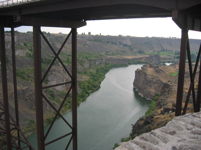
Twin Falls, ID. A huge bridge, partly seen in the photo, joins parts of the city on both sides of the Snake River. The river, which provided a reliable source of water, flows the entire length of a very long, 50 mile wide, flat, and fertile valley called the Snake River Plain. This huge fertile plain, receiving water from the river and providing thin riverside forage, is why the Oregon Trail traveled 350 miles in this valley this way, and would continue West. Some 80 miles East of here, the wagons on the California Trail had turned away from the Oregon Trail and went South, to the deserts of Nevada. However, on both trails the pioneers had to cross the Snake River Canyon several times! Look long and hard at this photo and wonder how they did it! New topic: You will again note the dark color of volcanic rock. Geologist believe that the Snake River Plain occurred because a Hot Spot moved under the North American Plate causing enough volcanic explosive gouging, plus dust blow off , to dig a huge ditch. The rocks and dust were scattered all over Idaho, making thick layers still visible in the geologic record! And then, subsequent subsidence made the ditch deeper and wider. The whole thing filled level with later magma flows. This sounds fantastic, but the dust evidence is here to see in the surrounding mountains and the flat topped volcanic rock remains all over this level valley floor. This same hot spot is, they believe, what is creating all the Hot Geo-Activity at Yellowstone Park. They surmise that the whole of Yellowstone National Park will undergo the same above described cycles, and that its area will (long time in the future) add another 150 miles to the Snake River Plain! For more info see book Roadside Geology of Idaho.
************************************
(Photo = 124-2408 ...... ZMM Page = None ...... WayPt = 091i ~3600ft)