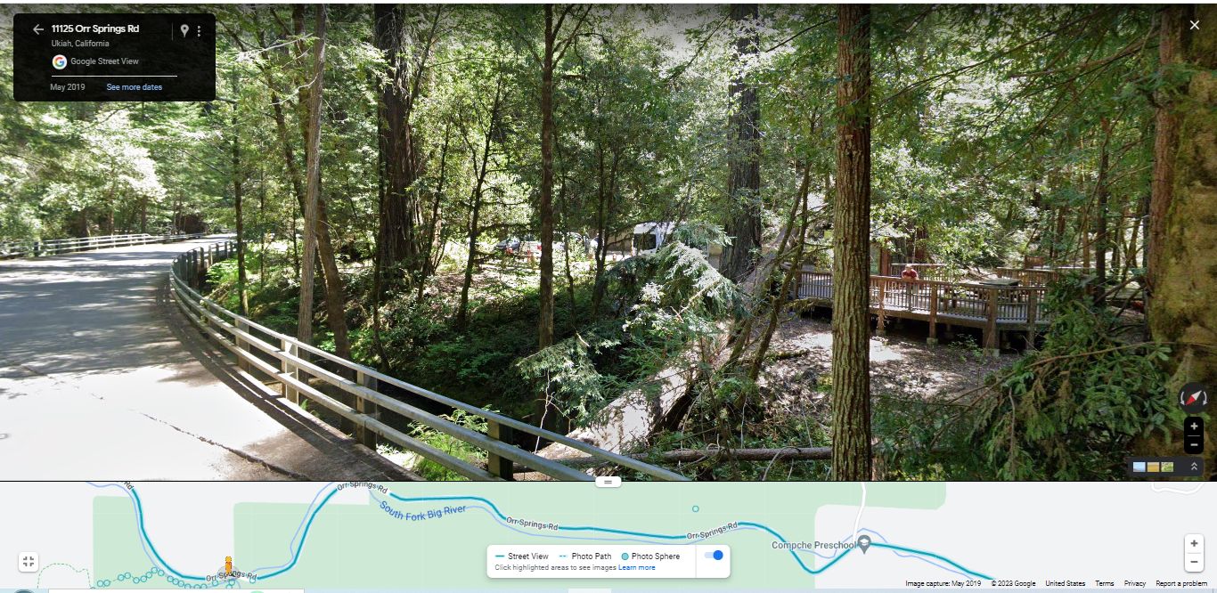
Continued From Previous Photo: Some 50 Feet From The Entrance Road Leading To The Montgomery Woods State Natural Reserve, A Google Street View (GSV) (Image May 2019), Screen Capture Photo Shows =>
At Left , Orr Springs Road On Bridge, Going Over The South Fork Big River.
And In Sunlight To Left Of Center, You See A Wooden Fence, That Continues To The Right Of The Photo , Where You See A Man.
Now Looking Closely To The Right Of The Man, You Can Discern A Picnic Table!
With Further Looking, You Will See That The Man & Picnic Table, Are On A Wooden Deck Built Partly Over The Edge Of The Adjacent South Fork Big River (SFBR).
At Lower Center Of Photo => Study The Low Area Beyond The Bridge Railing. This Is The Stream Bed Of The South Fork Big River, And In This Area Of California, Is Along The Orr Springs Road, Which Is The Same As The Comptche-Ukiah Road =>
[ . "What do you see?" I ask. .. "Its all different."
We head into a grove again, and he says, "Dont you get scared?"
"No, you get used to it."
I begin to feel drowsy and in a small ravine ahead I see a turnoff and a picnic table. When we get to it I cut the engine and stop.
"Im sleepy," I tell Chris. "Im going to take a nap."
"Me too," he says. ] (Cont Next)
************************
SUMMARY: As You Can See In The /\ Above /\ Photo, This Montgomery Woods State Natural Reserve Location, Is A Very Likely Place for The Narrators 1968 A Picnic Table.
The mission of institutions such as Montgomery Woods, includes making facilities available to the public, such as the deck and picnic table. And there is not really any reason for visitor facilities at other places along a relatively low traffic road. Private property owners would avoid such, and highway departments would consider a traffic hazard, unless they put in a Roadside Rest Area.
However, since a normal Narrow Ravine. Is Not Close By, The following would be a better ZMM Narrator Statement =>
.. in a small river valley ahead I see a turnoff and a picnic table.
Montgomery Woods State Natural Reserve, 11125 Orr Springs Rd, Ukiah, CA.
A) ~34.4 Road Miles East of Mendocino, CA and.
B) ~15.5 Road Miles West of Ukiah, CA.
************************
DATE-LINE: January 25, 2021. by Henry Gurr.
As Is Fully Discussed in The 1st & 2nd NEXT Photos => Originally I was convinced that > The Orr Hot Springs Resort , Was Practically The Only Place That Fits The Above Narrators Descriptions.
However, I finally was able to phone call talk to one of the Orr Resort staff persons who said =>
1) It was highly unlikely that they had a picnic table visible from the road. And
2) A Picnic Table by the road is/was very likely at the Montgomery Woods State Natural Reserve. Which =>
In The /\ Above /\ Photo You Can =>
A) Judge For Yourself Whether The Orr Hot Springs Resort, Is Practically The Only Place That Fits The Narrators Descriptions => Picnic Table Or Narrow Ravine. And =>
B) ALSO See Any Possible Ravines In A Topozone Map.
1) For example, using Blue Link below, I have studied, along both sides of the wider line marked Orr Springs Road, which is the same as Californias Comptche-Ukiah Road.
My study started at Melbourne, CA and followed this road trending East Southeast, to well past Orr Springs. Among possible candidates for The ZMM Narrators a small ravine , I picked out along the Northern Edge of Mountain Labeled MONTGOMERY WOOS STATE PARK, 3 ravines with small streams that flow ~South into the South Fork Big River, which is also where the road is.
Then I used Google Street View, to Drive step by step this same Northern Edge.
From This I Concluded => Because this section of road is all lowland along a river, there is plenty of water to make dense forest foliage, such that a traveler such as the ZMM Narrator could not see beyond ~ 10 feet from the road. This prevented seeing any ravines even knowing one was there. This is the case for all three of the above-mentioned 3 ravines with small streams. Two of these were respectively =>
a) At 10915 Orr Springs Road, where goes over a small side stream, which came out or a ravine not seeable with GSV
b) At 10823 Orr Springs Road, where goes by al side valley seen ToppZone, but not seeable with GSV.
CONCLUSION => : Given the above discussion, the Picnic Table at Montgomery Woods State Natural Reserve Location, Is The ONLY, Very Likely Place for The Narrators 1968 A Picnic Table.
C) You Can Further Conduct Your Own Study, Along, Using TopoZone Map =>
RIGHT CLICK AND SELECT NEW TAB => After Map View Comes Up, You Will See A Clutter of Adverts That Are Impossible To Eliminate => YOU BEST SHOULD =>
.Use Scroll Bar At Far Right => Adjust Green Topo Map Until You See JUST BELOW The Plus&Minus Upper Left. => A ClickOn For Full Scree. Click On It, And Adverts Will Be GONE.
.Then use, The Plus&Minus To Zoom. You can Click&Drag Map In Any Direction, and See More Off Your Screen Edges.
Now you are ready to do similar to my study at above => 1).
*************************
The /\ Above /\ Photo Is/Was A Screen Capture From => A Google Street View (GSV),. , Click Here To See The Wooden Deck With Picnic Table, AND/OR Do Your Own GSV Drive, In Either Direction..
*************************
(Photo = GoogStVu MontgomeryWoodsSt..PicnicTblOnWoodDeckOverRvr 11125OrrSpringsRdUkiahCA.jpg ...... ZMM Page = 371 ...... WayPt = 470i )
GPS Coordinates given In above Blue Link, Or Alternatively At Top of The Above-Mentioned TopoZone Map.