As We Pass Through Coastal Northern California Wine Country, The Freeway Becomes Wider and Wider.
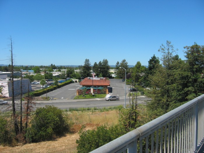
Standing On The Rt-12 Overpass Bridge And Looking Southwest, We See The Curved Ramp That Tell Us This Is A Cloverleaf Interchange. And Beyond Is A General View of Santa Rosa
The ZMM Route, After Traveling Back-Country, Ever Since The Interstate-90 In Missoula, MT, This Is Perhaps The First ~Big Population Cloverleaf Interchange!
[
The engine
drones on and on in its continuing oblivion to everything but its own internal forces. We pass through Asti and Santa Rosa, and
. ] (Cont Next)
NOTE: Now that we are suddenly aware that we are back into ~high population, we remember the ZMM Narrators =>.
lonely people. Its paradoxical that where people are the most closely crowded, in the big coastal cities in the East and West, the loneliness is the greatest.
Overpass bridge, Rt-12 intersection with US-101, Santa Rosa, CA. If you have been watching the elevation numbers you will have noticed a gradual drop in altitude from Ukiah, CA (545ft) to here at Santa Rosa, CA(116ft). This is the general drop of elevation as we come down the Russian River Valley that we have been following. The river itself cuts through the mountain range to the West about 11 miles back. But this valley apparently continues, albeit uphill, from here South for at least another 25 miles. Ahead you will see the elevations for Petaluma, CA (185ft) and Novato (415ft).
*************************
. And So We Ride On And On, Down Through Ukiah, And Hopland, And Cloverdale, Down Into The Wine Country.
.
Click Here For A Satellite View Showing At Center, The /\ Above /\ Photos Cloverleaf Interchange, In Californias Wine Country.
AFTER this Satellite View comes up =>
A) You well see US-101, With Hopland, CA at top and Novato, CA at bottom.
B) You will see that the GPS coordinates for Santa Rosa, CA are in URL Line in box at top.
C) Please ClickOn the Minus [-] Icon Lower Right, to Zoom-In, and see an Aerial View of the Cloverleaf Interchange.
*************************
(Photo = 117-1783 .... ZMM Page = 372 ...... WayPt = 482i 0116ft)