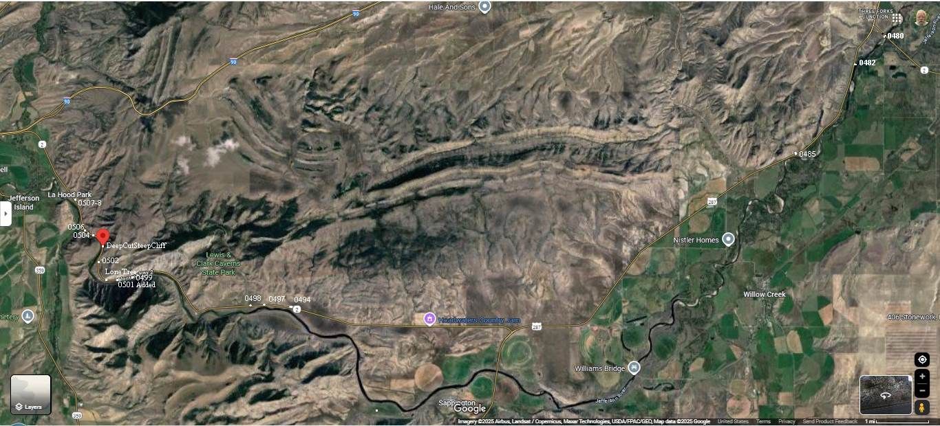
July 2024 Added:
A Satellite View Showing The Locations Of =>
A) The Historically Significant LaHood Park & Hotel, Which Is Along Rt-2 In the Jefferson River Valley.
B) The Historically Significant Lewis & Clark Caverns, Which Are Mentioned by The ZMM Narrator, And Are Also Along Rt-2 In the Jefferson River Valley.
NOTE: An extensive study this /\abpve/\ Satellite View, will help you understand the special locations of the Next Nine Photos.
For Examples, Please Notice The Following Shown In The /\Above/\ Satellite View, =>
1) At Mid Height Left => The small town of Jefferson Island, MT.
.. .2) Right Of Jefferson Island, MT, and along Rt-2 see=> LaHood Park, where are located TWO Historical Markers, which are extensively discussed with following photos.
3) At Right Of Center => Lewis & Clark Caverns.
. Look closely to see the Caverns Access Road, coming up from Photo Location Dot at 0498.
4) To left of 0498, unmarked is located => The Campground For => Lewis & Clark Caverns State Park.
5) Notice that the somewhat Brown Mountains at left of center, change to Green Irrigated Level Valleys, lower right. AND then, notice and remember that US-287 & Rt-2, run along the edge of this change!! .
6) Then know that after Three Forks, MT. the ZMM Route follows => US-287, which leads to Rt-2, which continues West, then Northwest, Then North to I-90, where the ZMM Route turns West to travel to Missoula, MT.
7) NOW, please take time to study the above-mentioned somewhat Brown Mountains and see =>
a) A Semi-Continuous Line Of Mountain Ridges, that runs from Upper Right, to where you see words Lone Tree.
b) Then notice that above and below the above-mentioned Mountain Ridges are noticeable Mountain Patterns that we all should ponder how all this came to pass.
c) Now notice the locations of the Jefferson River:=> Start Upper Right at Photo Locations 0480 thru 0485, and follow the at first twisty Jefferson River upstream, through a nearly flat level lowland agriculturally rich valley. to the lower center, and then, up the left side.
d) And left of lower center, notice how the river, no longer twisty, had to deep-cut through a mountain ridge to go North,
e) And, next notice that the river follows along the South edge of a mountain range, until it AGAIN, the river had to deep-cut through a mountain ridge to go North.
f) And, next notice essentially another repeat. => The river follows along the South edge of yet another mountain range (Photo Locations 0499 & 0501), until it AGAIN, the river had to deep-cut through a mountain ridge to go North, by Photo Location 0502.
g) And now finally, next notice essentially another repeat, although a much shorter distance => The river follows a short distance, along the Southwest corner of yet another mountain range (Photo Locations 0499 & 0501), until it AGAIN, the river had to deep-cut through a mountain ridge to go North, by Photo Location 0506. Here is where the most DRAMATIC photos are seen, and the location of the Swallows Nests, on the rock wall of a super steep deep cut.
OK, Hope you enjoyed the Geological & Geography Lesson!!
File = SaVu ZmmRoute3ForksJuntRt-2InJeffersonRvVlyL&CCaveLaHoodMT RedPinCutDp 14P#