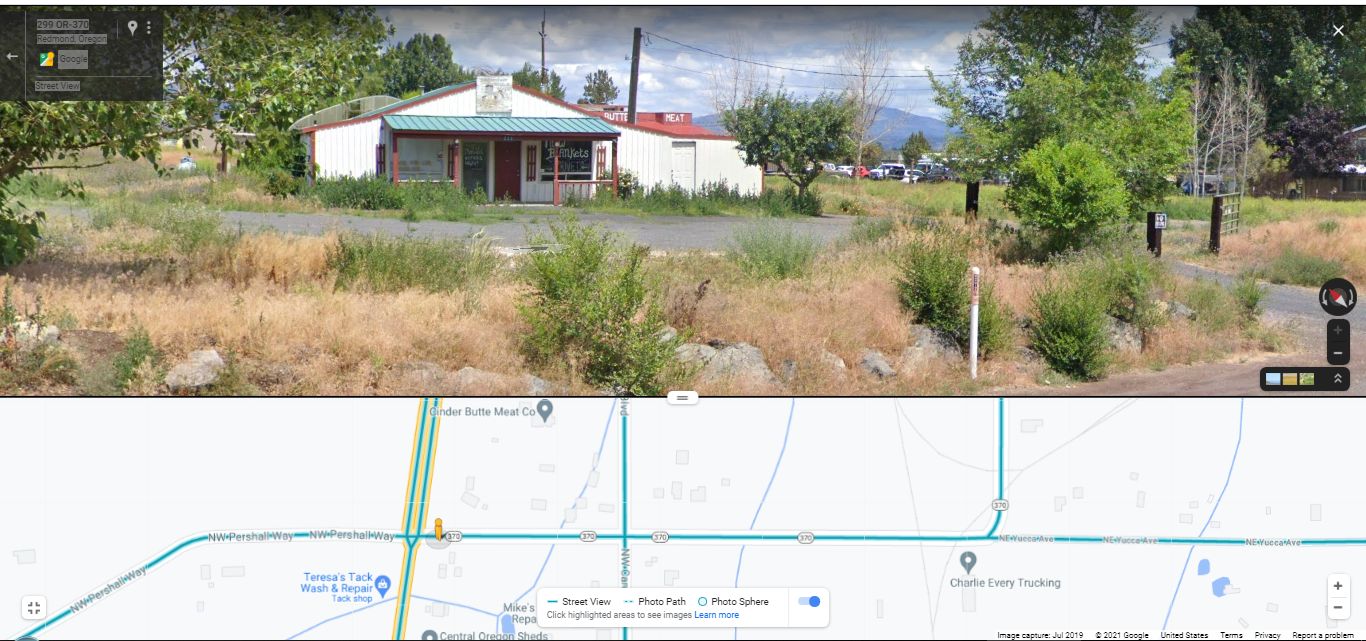
ZMM ROUTE RESEARCH RESULT #2 => A GOOGLE STREET VIEW SHOWS =>
...WHATS AT THE INTERSECTION OF US-97 & ONEIL HIGHWAY (Rt-370).
.At The Northeast Corner => This Google Street View #2 (GSV2) Shows The ONLY Business (Within A Mile) => That Is Remotely Similar To A Gas Station Where The ZMM Narrator Could Sit & Watch Drivers On US-97.
Studying This GSV#2, You Can Imagine => How This Building & Property Lay-Out, Could Have Once Been A Gas Station, Albeit Unusual In Appearance.
.The Other Three Corners Are => a) Bare Red Dirt, b) Dry Grass & Trees, and c) Homes Surrounded By Dry Grass & Trees.
.[ "We arrive in Prineville Junction with only a few hours of daylight left. Were at the intersection with Highway 97, where well turn south, and I fill up the tank at the corner and then am so tired I go around in back and sit on the yellow-painted cement curb with my feet in the gravel and the last rays of the sun flaring through the trees into my eyes.
. " ]
.I watch the cars go by for a while on the highway. Something lonely about them. Not lonelyworse. Nothing. Like the attendants expression when he filled the tank. Nothing. A nothing curb, by some nothing gravel, at a nothing intersection, going nowhere." (Cont. Next)
Traveling West On Rt-370 from Prineville, OR, Google Street View #2 (GSV2) of => The Only Business That Is Remotely Similar To A Gas Station Where Narrator Could Sit & Watch Drivers On US-97, Prineville Junction, OR. As discussed in the previous photo => The above ZMM Passage takes place in (or near) Prineville Junction, OR some 17 miles West of my Photos at WayPt = 354. And from Prineville, OR the only way most efficiently to get there, The Narrators ZMM Route follows the O'Neil Highway (Rt-370), in the scenic Crooked River Valley, and somewhat the route of the Prineville Railroad.
..****************..
Repeating Previous Photo Concerning Bottom Strip Map =>
.Click Photo To Get The Largest View, Then Look Closely =>The Bottom Strip Map Shows =>
1) Green Highway Line having Ovals with 370. This is ONeil Highway (Rt-370), and The ZMM Route from Prineville, OR, 17 miles to the East.
2) At Left: The Double Green Highway Line is US-97.
3) The Narrow Green Lines mark irrigation ditches.
4) The Narrow Very Faint Gray Lines Are Railroad Tracks.
5) Above the words Charles Every Trucking, you see Gray Railroad Track Lines that form kind of a curved triangle. There you can see where the Railroad Track =>
a) From the North switches into a curved track that goes EastNortheast. AND
b) From the South switches into a curved track that joins into a) above.
c) The approximately North-South Tracks are the Burlington Northern Santa Fe Railroad,
.6) IN SUMMARY: This is literally a Prineville Junction, achieved by the joining of Railroad Tracks! AND you can see how close this Railroad Prineville Junction is where The ZMM Passage says => Were at the intersection with Highway 97, where well turn south is described to take place.
..****************..
Due To The Narrator's Severe Depression And Fatigue, And Based On Evidence presented in the Previous 4 Photos & and above, I Believe that the Narrator, RIGHT HERE, at this /\ Above /\ Google Street View Business (or similar) Enterprise) => Makes an abrupt and major change of travel plans => Right here, to no longer travel West, but suddenly turn South !! As he sat on that => "nothing curb, by some nothing gravel, at a nothing intersection." .
..****************..
For Deeper Understanding, Please Read Our => ZMM Research Examination => Why ZMM Narrators Abrupt 90 Degree Turn South, At Prineville Junction, Oregon?
..****************..
EPILOGUE: CONCLUSION SUMMARY.
.The Narrator says => We arrive in Prineville Junction." This leads us to expect that there is a real town here.
.However, in Searching Satellite Images (Previous Photo Blue Link near Bottom), all around the literal Junction of the Prineville Railroad to the North-South Burlington Northern Santa Fe Railroad => It is discovered that there is certainly no town at all, nor any form of population center!
.In fact, there is hardly anything, except bare earth, scattered dry trees & weeds, and widely spaced businesses or homes, mostly stretched out along the busy US-97, a bit further North or South.
.As Variously Stated In The Previous 4 Photos =>
A) This Prineville Railroad Junction (Is Just A Dot On A map). And is found mostly only on OLD Road Atlas Maps
which is likely how Author Robert Pirsig knew of it ... and wrote it into ZMM.
B) Since Prineville Junction, OR Is No Longer On Current Day Maps, Nor Hardly Ever Really Existed as a town! => This is why it is so hard to find out anything about "Prineville Junction" Oregon by using Google
OR
Find its exact location using traditional paper maps.
INDEED SINCE THE 1974 PUBLICATION OF ZMM, PRACTICALLY THE ONLY INFERRED EXISTENCE OF THE TOWN OF => "PRINEVILLE JUNCTION" Is IN The Book Zen and the Art of Motorcycle Maintenance!!
*************************
(Photo =GoogStVu FauxGasStationNwCornerUS97Rt370 StpMapN-StrackJunctionTriangleTracks.jpg ...... ZMM Page = 293 ...... WayPt = NotAssigned )