Remember: Click On Photo Several Times To Get Largest View.
.....*** THIS GOOGLE STREET VIEW SHOWS AS FOLLOWS *** =>
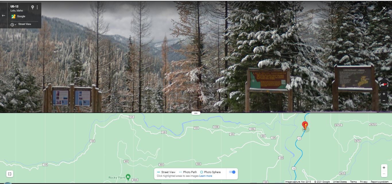
..A) A Bit Left Of Center Is => The Valley Scene Over The Lochsa River:
.((NOTE1: In the Strip Map at GSV bottom, you can discern => A) The Lochsa River and B) The Lewis & Clarks Rocky Point, AND also C) Forest Road 109 which will lead the traveler to Road 500, which is the Lolo Moterway. D) And finally at far right, you see US-12, which here is the ZMM Route. E) The \Red PinPoint of course marks the camera location of the seen /\ Above /\ Google Street View, which also happens to be Henry Gurrs 2002 WayPoint 264. ))
.(( NOTE2: On the very long Forest Road 500 (which is the Lolo Motorway, that was built along the existing Native Americans traditional Lolo Trail), which in turn, is where you can re-trace Lewis & Clarks Torturous, Treacherous Sept 16, 1806 Journey Trail. This is where they Experienced Stormy, Snow Packed, Cold Conditions FAR WORSE than the cold, gloomy scene, with deep snow, you see in the /\ Above /\ Nov 2015 Google Street View!! ))
..B) At Top Center & To Right Of The /\ Above /\ Mentioned Lochsa Valley Scene, Partly Obscured, Is The Crest Of The Mountains, Along Which Runs The Rightly Famous & VERY Historical Lolo Trail (The Next Photo Shows A Better View Of This Crest, there called The Highest Ridge:.)
..C) Low In The \ Above /\ Photo, You See Four Signs Respectively Describing Local Natural Idaho Scenery & History =>
..1) The Two Signs At Lower Left, Discuss With Photos, How forest landscapes are altered by fire. A close-up of these signs is shown in The SECOND & THIRD Next Photo, where you can fully read what it says.
..2) The Third Sign Numbered 334, discusses the June 29, 1806 Lewis & Clark Lolo Trail Crossing, which historically happened at this 4 sign location. A close-up of this sign is shown in The FOURTH Next Photo, where you can fully read what it says.
..3) At Lower Right is the Fourth Sign, which was placed by the USDA National Forest Service, and discusses. as it says On Signs Top => Checkerboard Legacy, and further discusses what is shown in the Map that is seen on the Signs Lower Right. Overall, this sign discusses The History Of National Forest Area Around The Sign.
A close-up of this sign is shown in The FIFTH Next Photo, where you can fully read what it says.
(Cont.Next)
NOTE: The /\Above/\ Google Street View Photo, shows the Winter Scenery of Nov 2913.
Click Here For A Google Street View Of This WayPoint 264 Location with Fall Scenery of Oct 2025. :
The /\Above/\ Google Street View Photo Is Located At => Henry Gurrs 2002 WayPoint 264, Three miles West, after top of Lolo Pass At MT & ID Border. (GPS = 46.5953 -114.60013)
************************
A MORE EXTENSIVE INTRODUCTION TO THE TOPICS OF THESE ABOVE-MENTIONED FOUR SIGNS: (NOTE: Each Blue Link below has Photos & Maps)
.1) This Area Of Idaho Is Called The Lolo Trail Corridor.
The Lolo Trail Corridor: This Rugged Mountainous Landscape, Is Just North of The ZMM Route (Which Here Is US-12), And Is Deeply Loaded With Many Histori8cal Points of Interest Re a) Early Native Americans.(Nez Perce) and b) Lewis & Clark Expedition.
.2) Our Adventure Traveling The Lolo Motorway, Which Mostly Follows The Lolo Trail, Which Is Also Close To The Travel Route Followed By Lewis & Clark.
.All This May Be Experienced By Driving => The Lolo Motorway => Where You Will See A Part Of The Important & Historic Lolo Trail Lolo Motorway Portion Of Our Loop Trip Through Idaho Wilderness. By Terry And Simone Kincaid, August 2-August 4, 2014. AFTER This Page Comes Up => You Can Read Discussion (Plus Many Good Photos & Map), Of What It Is Like To Drive The Lolo Motorway. Also given is how they accessed this road.
.3) A National Forest Service Summary & Explanation of => The Lewis and Clark Expedition Along => The Lolo Trail & The Lolo Motorway: Travel Excerpts From L&C Dairy / Journal, A Somewhat Day By Day Report, Across The Lolo Trail, In September 1805 And June 1806. AFTER this page comes up you can read about => The [historical] sites [that] are listed and numbered east to west, as you will find them, on your travels across the Lolo Trail and the Lewis and Clark route along the Lolo Motorway. (Sites are numbered on the map [given]. Also given are very specific instructions as to how to access this road, from either the East or West ends. )
.4)
Click Here For A Google Satellite View Showing The Lolo Motor Way.AND, This Page at Left, Has 9 Good Photos Of What Is Seen Along This Route.
5)
.To Learn More About The Lewis & Clark Expedition, Read A VERY Interesting Day By Day, Summary Synopsis Sketch, Of Their Journey, with Excerpts From L&C Journal Writing, Supplemented With Images Of Maps Sketched by Lewis or Clark. AFTER this page comes up, you will read that L&C are asking Native Americans how to reach his relations, meaning go into the high mountains of what we know as Eastern Idaho.
NOTES ON => HOW TO BEST USE THIS /\ABOVE/\ LEWIS & CLARK EXPEDITION PAGE =>
a) Three Inches down, at Left in Box With (curved ends)
Click To Go To The Previous Day AND
b) Three Inches down, at Right in Box With (curved ends)
Click To Go To The Following Next Day.
b) At Top => The URL line has 18050910 which means 1805 September 10.
*************************
(Photo = File = GoogStVu4Sign+CrookdRVly+MtsOfLolorTrailHorizRdgStpMap}FrstRd109+500+RkyP.jpg...... ZMM Page = 243 ...... WayPt = 264w 4460ft)
