Back On the Road To The West, Which Is To The Left Along The Road
AS WE LEARN ABOUT GUMPTION.
All Around Us, All We See Are
Awesome Baked-Dry Hills.
*******************
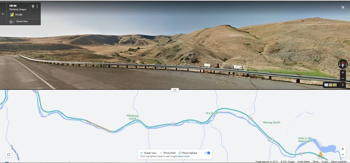
Just Left Of Center Is Where Hole-In-The-Wall-Gulch Comes In.
.And The Two Signs Explain Respectively The Local Area & The Previous Photos Landslide, Which Is A Bit Off Screen At Right.
.
. then we get on and are moving again.
.... The gumption-filling process occurs when one is quiet long enough to see and hear and feel the real universe, not just ones own stale opinions about it. But its nothing exotic. Thats why I like the word.
.... You see it often in people who return from long, quiet fishing trips. Often theyre a little defensive about having put so much time to "no account" because theres no intellectual justification for what theyve been doing. But the returned fisherman usually has a peculiar abundance of gumption, usually for the very same things he was sick to death of a few weeks before. He hasnt been wasting time. Its only our limited cultural viewpoint that makes it seem so. " (Cont. Next)
Land Slide Area, Rt-86, ~12 Miles WestNorthwest of Richland, OR.
.Continued from The SECOND Previous Photo => In The /\ Above /\ Google Street View, above the guard rail to left of center, you can see the same view of the stream and a stretch of the old gravel Rt-86.
. Above guard rail, to right of center you can see the Two Interpretive Signs that respectively tell about the Area Scenery & History. AND how The Rockslide covered up part of the old gravel Rt-86, both of which were seen in PREVIOUS Photo.
.Apparently, the Oregon Highway Department, decided there was still too much danger of more rockslides, and chose to make the new road, high up here, at added cost of 2 additional bridges.
.One of these two New Bridges is seen at lower right, just left of the Orange Pegman => in the /\ Above /\ Google Satellite Strip Map (bottom). Also in the Strip Map, you can see that the new road is shorter & straighter.
.In the /\ Above /\ Photo => The stream gets larger as it flows East to the right. And although this stream seems not to have a name here, eventually, before it flows into the Snake River, it is called Powder River. But this Idaho River, is not to be confused with the Powder River in Montana, which also is along the ZMM Route.
..****************..
Right Click and Select New Tab. And AFTER This Satellite View Comes Up, You Can See The Above Discussed Places As Follows =>
A) The NEW Rt-86 Marked By the White Circles, South of The Stream.
B) The OLD Rt-86 ALSO Marked By the White Circles, in many places North of The Stream. The places where Old Rt-86, NORTH of the stream, is running close to the green, which is vegetation watered by the stream.
C) Now, looking at the part of the New Highway that is SOUTH of the Stream =-> At EACH END you will be able to see the Two New Bridges.
D) Also, at top you can see the Rock Slide, as well as where the Rockslide covered the Old Rt-86 and blocked the stream. You can Zoom-In to see close up details.
*************************
(Photo = GoogSatHoleInWallGulch&LandSlidePowderRv WyPt300Rt8612MiWnwRichlandORwide.jpg ...... ZMM Page = 273 ...... WayPt = 300i2 2552ft. Photo at WayPt = 301w 2970ft)