June 30, 2002 And Saturday, July 20, 2024
.Checkerboard Legacy.
The Fourth Of Four Roadside Signs, Which Are Shown In The Previous Photo Of A Google Street View, And The 4 Signs Happen To Be At Henry Gurrs 2002 WayPoint 264.
Remember To Click Several Times For Largest View: Then You Can Clearly Read What This Sign Says
WayPoint 264. Three miles after top of Lolo Pass At MT & ID Border. (GPS = 46.5953 -114.60013)
************************
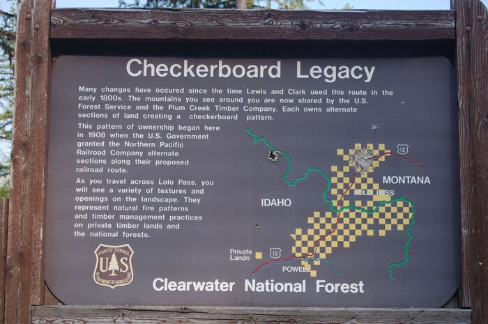
This Sign Posted By USDA National Forest Service, At Top Says Checkerboard Legacy, and Discusses The History Of The National Forest, That Is Shown In Map Seen Lower Right.
.This Checkerboard Legacy, Is About The History Of The National Forest All Around This Sign.
EXPLANATION:
Back in ~2004, The existence of this Checkerboard Legacy Sign, became known to me, while I was looking for the presence any buildings along this stretch of road:
.I was doing a Google Street View Drive, click, click, down from Lolo Pass.
AND the /\Above/\ Photo shows Sign I saw here at my WayPt =264, also the 3 Signs seen in the PREVIOUS THREE Photos.
.But because GSV was not clear enough, just what the sign said was a mystery, until by pure accident, I found the Above /\ Photo posted, as an extra, on a Google Satellite View for Lochsa Lodge, which included ~300 photos added by interested persons.
.You will see two more of these ~300 photos in forthcoming photos.
. As Mentioned Above =? Click Here For A Satellite View Of Lochsa Lodge Buildings & Driveways. AND AFTER This Satellite View Comes Up, Click Upper Left For Over ~300 Photos Of Lochsa Lodge Resort AND Local Scenery
*************************
(Photo = DSC_0620 Resize1504x1000 ~154KB...... ZMM Page = 243 ...... WayPt = 264w 4460ft)
2004 photo was GoogSatPixLoloLodge}CnfSignCheckerboardtLegacy{H.istoryClearwaterNatFstAroundSign