Saturday, July 20, 2024:
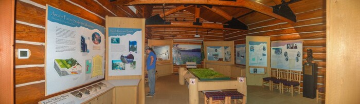
A Panorama View Inside => The Lolo Pass, National Park Service And States of Idaho & Montana, Visitor Information Center.
As You Can See, There Are Loads Of Displays About This Lolo Corridor Area.
Lolo Pass, MT & ID Border.
When Henry saw maps on display, automatically spontaneously he thought to ask => Is there a map that shows Historical Points of Interest Such As =>
a) Early Native Americans.(Nez Perce) and
b) The Lewis & Clark Expedition.
c) The so called The Lolo Motor Way, which mostly follows The Lolo Trail, which was created close to portions of the travel route followed by Native North Americans and then later by Lewis & Clark.
.d) A National Forest Service Summary & Explanation of => The Lewis and Clark Expedition Along => The Lolo Trail & The Lolo Motor Way
The answer to the above question was => Yes: All of these are shown on this a USCA & Notional Forest, 4 x 4 foot Wall Map of the Clearwater National Forest. All this, and also shown are a great amount of other historical and visitor information!
NOTE: Portions Of This Map, are shown in the FOLLOWING TWO Photos.
Accompanying The NEXT Approximately ?TWELVE? Photos, You Will Find Additional Road Information, Maps, Satellite Views, Google Street Views, & More Information About The Above Topics.
************************
File File = DSC 0601 FlatWorldStitch Resize1377x400