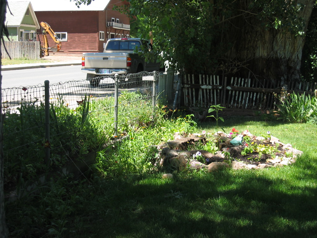
A View 30 Feet West (Right) of Previous Photo: Same Lush Green Yard & Fence. But the Irrigation Ditch Is Barely Discernable.
.John sees Im awake and we talk a little. He says the irrigation water comes from the "Chinamans Ditch." "You never could get a white man to dig a ditch like that," he says. "They dug that ditch eighty years ago when they thought there was gold here. You couldnt get a ditch like that anywhere nowadays." He says thats why the trees are so big. (Cont.Next)
Business district, Dayville, OR. From reading ZMM I got the idea the ditch by these trees was quite large. As you can see in my photos, the ditch by the trees is unused and partly filled in. It probably was never any more than a 8 inches deep and sixteen inches wide. This is probably because this was just a minor branch of a much larger irrigation canal system. The Chinamans Ditch probably was huge at its main flow outside the town. This is because it probably supplied agriculture irrigation to many ranches in addition to the town itself.
..****************..
.THE WATER FOR THE CHINAMANS DITCH PROBABLY CAME FROM A GREAT DISTANCE UP IN THE HILLS.
A) Topozone map for Dayville, OR shows a Dark Green Line, Southwest Of Town, That Is Likely The Larger Main Chinamans Ditch since it systematically follows the contour lines, for a long distance South, upstream, along the South Fork John Day River. If you ClickDrag till you see the top edge of Quadrangle 24, you will see flume, which marks where this Dark Green Line joins a similar line on the east side of this river. All this says these are irrigation ditches.
. The above ZMM Passage says =>"They dug that ditch eighty years ago when they thought there was gold here
, and went on to imply that a town plus agriculture could never have enough money to pay for digging this Chinamans Ditch, and the money came from Gold Mining!..
.. So
still to be researched is => How & where did the water get sent to the location of the gold mining. Perhaps further study of the Topozone maps may show the old mine and its own separate ditch. Right Click And Open In A New Tab. =>
.After Map View Comes Up, You Will See an Awful Clutter Of Adverts That Are Impossible To Eliminate. => You Best Should =>
.Use Scroll Bar At Far Right To Adjust Green Topo Map Until You See JUST BELOW The Plus & Minus Upper Left => A Click-On For Full Scree. Click On It, in ~40 seconds the screen will fill, and Adverts Will Be Gone.
.Then use Plus & Minus To Zoom. You can Click&Drag Map In Any Direction, To See More Off Your Screen Edges.
B) Southwest Of Dayville, OR, Satellite View Also Shows Likely The Same Larger Main Chinamans Ditch.
. After this Satellite View comes up, you will see in the desert left side of screen, a dark line dotted with trees. This Line, fits very well the shape of Green Line shown in the above Topo Map! AND just like for the above-mentioned Topo Map, this Line can be followed, for a long distance South, upstream along the South Fork John Day River.
C) Southeast Of Town, Google Street View Shows Water Flowing In Likely A Branch Of Chinamans Ditch.
. After this Google Street View comes up, you will see, an example of this Chinamans Ditch, with flowing water at screen center.
AND the Bottom Of Screen Strip Map shows many fine blue lines, which are evidently irrigation ditches, since one such line comes to the road right AT the Stickman, which is the location of this street view.
AND on the left of the Strip Map, you see a portion of an irrigation ditch, the shape of which, fits well that-mentioned and shown in the above Topo Map and Satellite View.
D) The Google Street View (GSV), Blue Link Above Allows You To GSV Drive Along The Highway Into Dayville, OR, And See The Big Trees.
.INSTRUCTIONS =>After Google Street View (GSV) Comes Up, click the Google Street View Image, WHERE you want the VIEW to go. Thus you can successively Click-Click-Click = GSV Drive along the street you see on your computer screen. You can even click on a side street to GSV Drive the side street !!
You can always GSV Drive further to see more & more sights!! AND, at any time, you can Click-On The Plus & Minus to Zoom. AND, you can Click&Drag the Image On Screen in any direction, for a better view.
*************************
(Photo = 112-1266 ...... ZMM Page = 288 ...... WayPt = 335w 2404ft)
