Salmon River Canyon. A View North, Back Towards White Bird, Showing The Roads Gradual Descent To Rivers Side.
.
. flowing between high canyon walls. (Cont. Next)
North end of Huge Parking Lot for Roadside Rest Area and a nice Sandy River Beach, Skookumchuck Recreation Site (Click Here For Satellite View.)
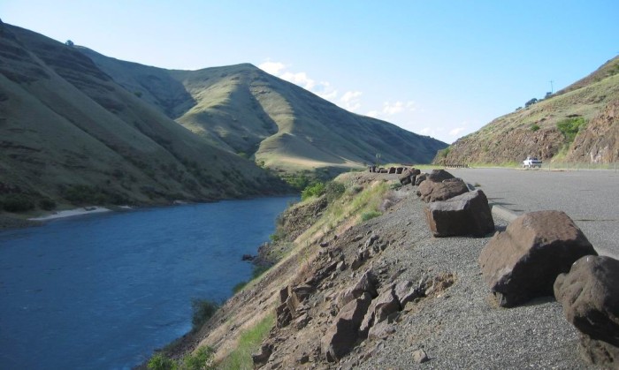
Salmon River Gorge, ID. Note boulders that are volcanic rock. These surely came out of similar appearing rock seen at road cut in canyon wall at right.
.We are now four miles South of White Bird. After the bridge shown in the previous photo, US-95 went up and over a small mountain range. After this, the highway took a steady down grade to practically the level of the river, as seen /\ Above /\ Photo.
.The new highway has been fairlly straight, with its steady, reasonable grade down, ever since the Grangeville Plateau. Clearly, it is much safer and more amenable to high speed traffic than the ~22 switchbacks on White Bird Hill!!
But How Did Idaho Find The Money For The Very High Bridge Plus Expensive Road Relocation To Make The Newer, Wide, Straight Modern Superhighway?
.How could this be justified in this remote, arid, lowly populated region? A quick look at your Idaho map will show the answer. This is only road between the widely separate, but clearly well populated Northern and Southern regions of Idaho.
.Moreover the only other North-South road corridors are 120 miles to the East, and even farther to the West.
.Why is this so? More map study will show the major (and long) North-South mountain barriers both East and West of US-95. In addition, the deep precipitous Salmon River Gorge, combined with the Snake River (Hells Canyon) to the West, are together additional North-South barriers to road construction. (These rivers after all, are just following the North-South Mountain folds generally true of the West.)
.So, do you get the point? Roads respond to Geology, and Geography. Here the Salmon River Gorge, makes the ONE GOOD WAY through these precipitous mountains. The fast and heavy long distance traffic on this road, both justify and make good use of this highway in its modern form.
NOTE: AFTER the Blue Link above comes up, you can ClickDrag the Satellite View, back North along US-95, to see town of White Bird, ID. Then North & bit East, you can see the ZMM Narrators rough & tough gravel road back in 1968, with some 22 switchbacks, winding down White Bird Hill!! .
*************************
(Photo = 111-1142c ...... ZMM Page = 260 ...... WayPt = 285w 1579ft)