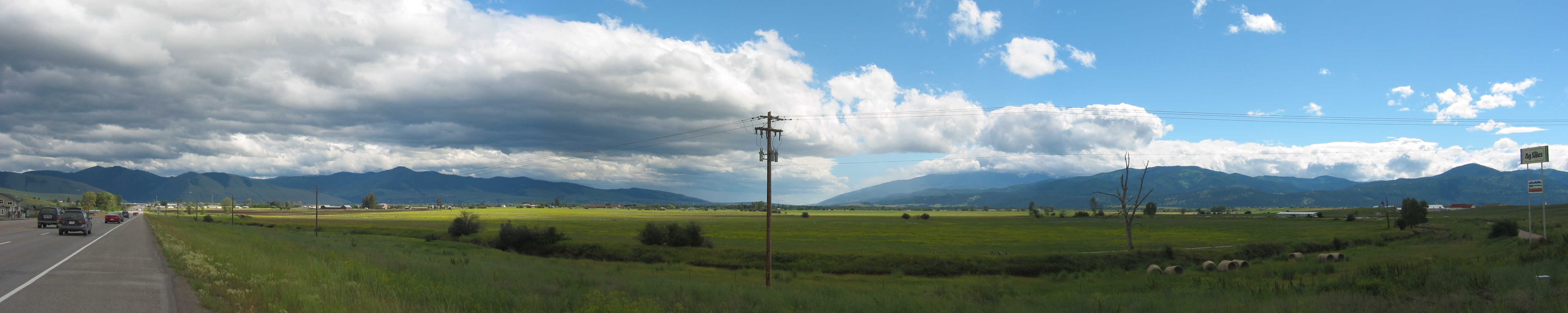
A THREE PHOTO PANORAMA. =>
Starting At The Left Edge, You Can (Above Clump Of Trees At Highway Edge), See (The Previously Mentioned And Shown In The Previous Photo), Deep Crack Between The Green & The Black In The Mountains. This Is Where I-90 Came Down The Pass From The East.
.AND Looking To The Right, See The Letter M, Shown In White Rocks On a High Mountainside, Below Which At Mountain Base Is University of Montana. .
.With ClickDrag Bar, Gradually Scroll This Panorama (Which Happens to Includes 2nd Previous Photo) To The Right -=> You Will Successively See =>
..A) The Buildings of Eastern Missoula, MT, And Beyond Is University of Montana.,
..B) The Big Electric Power Pole, Which On Center Shows => Missoulas Long Narrow Valley Stretching Out To The South, With Mountains On Both Sides.
..C) Please Scroll The panoramas So Big Electric Power Pose Is Center Screen & Study => The Mountains On Both Sides Of This Wide Valley, And Know That => Along The Base of the Bitterroot Mountains at Right Edge Of This Valley => North Flows (Toward The Camera) The Bitterroot River, With US-93 Having Staying Close, Practically From The Montana Idaho Border, 94 Miles, Almost Directly South Of Here.
..D) Just A Bit Right Of The Electric Power Pole, ~4 Miles Beyond The Line OF Darker Green Trees, Is Where =>The Bitterroot River (Flowing North Toward The Camera), Junctions with and Flows Into The Clark Fork Of The Columbia River.
..E) Then ClickDrag To Almost The Right Edge Of Photo, To Where You See ABOVE The Long Low White Building, The More Distant Partly Snow Covered Mountains, At The Horizon. These Are Part of The Bitterroot Mountain Range, Upon Which The ZMM Route Will Climb, To The Narrators Lolo Pass., Where He & Chris Enter Idaho.
. and then somewhat wearily head out of Missoula toward Lolo Pass. (Cont. next)
-
Missoula, MT. At (GPS 46.91198 -114.0651)
In This Satellite View You Can See =>
In This Satellite View, The Above-Mentioned River Junction Happens Four Miles Northwest Of Central Missoula, MT, Where On Satellite View, The RedPinpoint Marks This /\ Above /\ Photo Location.
..****************..
. Viewing Instructions For Above Blue Satellite Link.
.AFTER Satellite View Comes Up =>
..A) RedPinpoint On Satellite View, Marks The /\ Above Panorama Photo Location (WayPt = 256). And about 4 Miles Southwest of this Satellite View RedPinpoint Location, you can see where the Bitterroot River flowing from the South, joins the Clark Fork River flowing from The East. Where the combined waters move Northwest, to eventually join the Columbia River, flowing to the Pacific Ocean.
..B) At lower Right, you can see words University of Montana, and above see the RedWhiteBlue Icon of I-90. This marks approximately (WayPt = 255) of the Previous Photo.
C) You Can See => The I-90 Highway, from the East, down into Missoula, MT and the long narrow valley stretching out to the South, with Mountains on both sides.
D) And, looking at the mountains on West Valley Side, you can pick out.at The Base of the Bitterroot Mountains, the => North Flowing Bitterroot River, With US-93 Having Staying Close, Practically , 94 Miles, From The Montana Idaho Border.
E) Of course, The I-90 Highway, from the East, down into Missoula, MT, traces the above mentioned crack between the green and the black.
F) You can see The ZMM Route roads to Lolo, MT (and Lolo Pass and thence into Idaho) as follows => I-90 Highway West to Rt 93. Turn South to Lolo, MT, and there turn West onto US-12, there twisty windy, climb the mountainsise, toward Lolo Pass and the border of Idaho.
*************************
(Photo = 109-1024 + 109-1025 + 109-1026sc ...... ZMM Page = 242 ...... WayPt = 256w 3239ft)